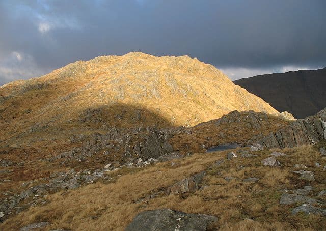
Corbett · Knoydart
Buidhe Bheinn
Buidhe Bheinn is the long, twisting ridge that runs south from the Bealach Duibh Leac in South Glen Shiel, falling away in steep grass and crag toward the head of Loch Hourn. It is often climbed in conjunction with the higher Munro Sgurr na Sgine on its north-east end, but its own 885m summit is set apart enough — three subsidiary tops along the ridge — that most baggers treat it as a day in its own right. The view south across Loch Hourn to Ladhar Bheinn and Knoydart is one of the most striking on the mainland.
Gaelic: “yellow” · Pronunciation: boo-yeh bheinn
Quick facts
- Height
- 885.5m/ 2905ft
- Prominence
- 165 m
- Distance
- ~16 km
- Ascent
- ~779 m
- Time
- 5–8 hrs
- Grid ref
- NG963090
- Parking
- NG969143
- Nearest city
- Fort William· 38km
- Dogs
- Dogs on lead required near livestockDog-friendly guide ↗
Height and prominence cross-checked against the Database of British and Irish Hills (CC BY).
No GPX track yet
Walked this route? Share your track to help other walkers.
Standard route
stalkers path 30% · bealach path 15% · grassy ridge 45% · summit top 10%
Start from a lay-by on the A87 in South Glen Shiel and follow the stalkers path up Allt Coire Toiteil to the Bealach Duibh Leac — the same approach used for Sgurr na Sgine. From the bealach, turn south and follow the airy ridge over a series of bumps to the highest point. Around 16km return with 779m of ascent. Strong parties combine the day with Sgurr na Sgine and The Saddle, but Buidhe Bheinn alone gives a fine moderate Corbett with one steep pull.
Terrain
The Coire Toiteil stalkers path is steep and slippery in places where it crosses bare bedrock, but otherwise gives good progress to the bealach. The ridge itself is grassy with intermittent rock outcrops — straightforward in good visibility but the subsidiary tops can confuse on the way back, with one false summit south of the main top. The west flank above Loch Hourn drops away steeply.
In winter
In winter the steep west face holds snow into late spring and is a recognised avalanche slope after westerly loading; cornices form on the north-east edge above Coire Toiteil. The bealach itself is a notorious wind tunnel. Most parties keep to the broad east flank of the ridge for safer footing.
Kit for this: the winter Munro kit list · which boots take crampons
Best time of year
Getting there
- Glasgow3h 1m
- Edinburgh4h 35m
OS maps: OS Landranger 33
Mobile signal: No signal in Glenelg; completely isolated from the network
Current conditions
Daylight Today
- Sunrise
- 07:52
- Sunset
- 18:23
- Civil dawn
- 07:13
- Civil dusk
- 19:02
NOAA Solar Calculator · 14 October 2026
Around Buidhe Bheinn on the SCOT network
Getting there, basing yourself, and what to do off the hill.
Buidhe Bheinn — common questions
- How difficult is Buidhe Bheinn?
- Buidhe Bheinn carries a 4/5 (challenging) grade on the OutdoorSCOT scale. Count on about 16km, 779m of ascent and a 5-8 hour day on the standard route. Underfoot: The Coire Toiteil stalkers path is steep and slippery in places where it crosses bare bedrock, but otherwise gives good progress to the bealach.
- What is Buidhe Bheinn's prominence?
- 165m of prominence. That's the vertical drop from the summit to the col that links Buidhe Bheinn to the next higher ground.
- Where do I park for Buidhe Bheinn?
- Most walkers start from NG969143. Verify the grid reference on an OS map before you set off — space is tight on busy summer weekends.
- When is the best time to climb Buidhe Bheinn?
- May, June, July, August, September give the most reliable conditions on Buidhe Bheinn. Beyond that window the high ground turns wintry: carry full mountain kit, be confident navigating, and check the SAIS avalanche forecast for the area.
- Is Buidhe Bheinn dog-friendly?
- Yes, but dogs must be kept on a lead — there is livestock or ground-nesting bird interest on the route.
- Is there mobile signal on Buidhe Bheinn?
- No signal in Glenelg; completely isolated from the network
- Is Buidhe Bheinn safe in winter?
- In winter the steep west face holds snow into late spring and is a recognised avalanche slope after westerly loading; cornices form on the north-east edge above Coire Toiteil. The bealach itself is a notorious wind tunnel. Most parties keep to the broad east flank of the ridge for safer footing.
Get the OutdoorSCOT weekly
One email a week — new route, hill and bothy guides, seasonal conditions and the odd hard-won lesson. No spam, unsubscribe in one click.