Munro · Kintail
Sgurr a' Mhaoraich
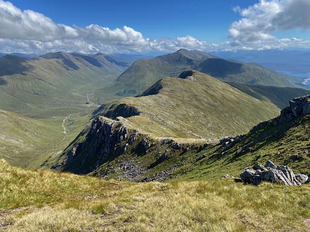
Sgùrr a' Mhaoraich (1026m) — "peak of the shellfish" — is the isolated rocky Munro that dominates the western end of Loch Quoich, looking south into the heart of Knoydart and west to Loch Hourn. The hill is one of the most viewpoint-rich summits in the Western Highlands, with the seaward Knoydart Munros (Ladhar Bheinn, Luinne Bheinn, Meall Buidhe) laid out below. The standard ascent up the long east ridge from the Loch Quoich road is one of the finest sustained ridge climbs in the region.
Quick facts
- Height
- 1026.6m/ 3368ft
- Prominence
- 708 m
- Distance
- 17 km
- Ascent
- 903 m
- Time
- 6–10 hrs
- Grid ref
- NG983065
- Parking
- NG994040
- Nearest city
- Fort William· 35km
- Dogs
- Dogs on lead required near livestockDog-friendly guide ↗
Height and prominence cross-checked against the Database of British and Irish Hills (CC BY).
No GPX track yet
Walked this route? Share your track to help other walkers.
Standard route
Roadside path 20% · Steep hillside 50% · Summit ridge 30%
Park at the modest pull-off above the Loch Quoich road, a short distance east of the dam. Climb directly north on a clear path onto the long east ridge of Sgùrr a' Mhaoraich, which gives a sustained but steady climb of 900m over 4km with several rocky scrambling steps near the top. The summit is a rocky platform with a small cairn perched above the north-east corrie. Most parties return the same way. Around 11km with 1020m of ascent — a focused single-Munro day.
Terrain
The Loch Quoich roadside path starts as faint stalkers' track. The east ridge above is broad short turf and rocky outcrops, with a clear path that picks a line between the rocky bands. Higher up the ridge narrows briefly with one or two hand-on-rock scrambly steps — exposed but easy in dry conditions. The summit is a small rocky platform with the cairn perched at the edge of the north-east face. No scrambling difficulty above Grade 1.
In winter
A serious west-coast winter Munro. The Loch Quoich access road is among the first in the area to drift closed in heavy snow. The east ridge rocky steps glaze readily and can become a Grade I winter scramble. The north-east face is a recognised avalanche slope after south-westerly storms. Cornicing along the summit ridge is consistent. SAIS Northern Highlands applies. Phone signal absent throughout the day.
Best time of year
Getting there
- Glasgow3h 57m
- Edinburgh4h 32m
OS maps: OS Landranger 33
Mobile signal: Nothing above 700m at Loch Quoich. Sort maps before departing the main A87.
Current conditions
Daylight Today
- Sunrise
- 05:02
- Sunset
- 21:54
- Civil dawn
- 04:06
- Civil dusk
- 22:50
NOAA Solar Calculator · 23 July 2026
Pair with
Curated multi-hill combinations from Sgurr a' Mhaoraich.
Around Sgurr a' Mhaoraich on the SCOT network
Getting there, basing yourself, and what to do off the hill.
Sgurr a' Mhaoraich — common questions
- What difficulty is Sgurr a' Mhaoraich?
- On the OutdoorSCOT scale, Sgurr a' Mhaoraich comes in at 3/5 — moderately challenging. Expect roughly 17km and 903m of ascent on the usual route — 6-10 hours for most parties. Underfoot: The Loch Quoich roadside path starts as faint stalkers' track.
- What is Sgurr a' Mhaoraich's prominence?
- 708m of prominence. That's the vertical drop from the summit to the col that links Sgurr a' Mhaoraich to the next higher ground.
- Where do I park for Sgurr a' Mhaoraich?
- Most walkers start from NG994040. Verify the grid reference on an OS map before you set off — space is tight on busy summer weekends.
- When is the best time to climb Sgurr a' Mhaoraich?
- May, June, July, August, September give the most reliable conditions on Sgurr a' Mhaoraich. Beyond that window the high ground turns wintry: carry full mountain kit, be confident navigating, and check the SAIS avalanche forecast for the area.
- Is Sgurr a' Mhaoraich dog-friendly?
- Yes, but dogs must be kept on a lead — there is livestock or ground-nesting bird interest on the route.
- Is there mobile signal on Sgurr a' Mhaoraich?
- Nothing above 700m at Loch Quoich. Sort maps before departing the main A87.
- Is Sgurr a' Mhaoraich safe in winter?
- A serious west-coast winter Munro. The Loch Quoich access road is among the first in the area to drift closed in heavy snow. The east ridge rocky steps glaze readily and can become a Grade I winter scramble. The north-east face is a recognised avalanche slope after south-westerly storms. Cornicing along the summit ridge is consistent. SAIS Northern Highlands applies. Phone signal absent throughout the day.
Get the OutdoorSCOT weekly
One email a week — new route, hill and bothy guides, seasonal conditions and the odd hard-won lesson. No spam, unsubscribe in one click.