Munro · Kintail
Sgurr an Doire Leathain
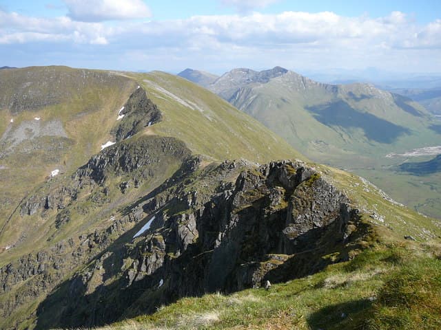
Sgùrr an Doire Leathain (1010m) — "peak of the broad thicket" — is the highest of the western Munros on the South Glen Shiel ridge, the long sustained chain of seven Munros that walls in the southern side of Glen Shiel. It sits between Maol Chinn-Dearg and Sgurr an Lochain near the western end of the ridge. The summit cone is a small pointed top with views west into Knoydart and north across to Beinn Sgritheall and the Five Sisters.
Quick facts
- Height
- 1010m/ 3314ft
- Prominence
- 189 m
- Distance
- 17 km
- Ascent
- 889 m
- Time
- 6–9 hrs
- Grid ref
- NH015098
- Parking
- NH077117
- Nearest city
- Fort William· 37km
- Dogs
- Dogs on lead required near livestockDog-friendly guide ↗
Height and prominence cross-checked against the Database of British and Irish Hills (CC BY).
No GPX track yet
Walked this route? Share your track to help other walkers.
Standard route
Steep hillside 35% · Ridge walk 50% · Summit 15%
Almost always tackled as part of the full South Glen Shiel ridge traverse (see Aonach air Chrith). Park at the Cluanie Inn or arrange transport for the Shiel Bridge end, then traverse the seven Munros from east to west: starting with Creag a' Mhaim and Druim Shionnach, then onto Aonach air Chrith and Maol Chinn-Dearg, before crossing Sgurr an Doire Leathain to Sgurr an Lochain and finishing on Creag nan Damh. Around 22km with 2000m of cumulative ascent. Direct ascent of Doire Leathain alone from the A87 is brutally steep at around 8km return with 900m.
Terrain
The crest of the South Glen Shiel ridge is broad mossy turf along almost its full length — easy underfoot but the constant up-and-down between summits adds up. The Sgùrr an Doire Leathain summit cone is a small rocky top with a clear path. The drop west to the bealach for Sgurr an Lochain is steep grass; the drop east to the Maol Chinn-Dearg bealach is broad and easy. Direct A87 ascents from Glen Shiel are unremittingly steep grass slopes.
In winter
A serious winter ridge traverse. The crest develops continuous cornicing on both sides depending on wind direction. The ridge is committing once gained — escape options are limited to steep grass slopes dropping back to the A87. The A87 itself stays gritted but Cluanie sits in a snow-trap. No mobile reception on the crest; consult SAIS Northern Highlands for avalanche guidance.
Best time of year
Getting there
- Glasgow3h 59m
- Edinburgh4h 32m
OS maps: OS Landranger 33
Mobile signal: No signal on the ridge. Glen Shiel road has occasional pockets of signal. Download OS Landranger 33 before setting off.
Current conditions
Daylight Today
- Sunrise
- 05:02
- Sunset
- 21:54
- Civil dawn
- 04:06
- Civil dusk
- 22:50
NOAA Solar Calculator · 23 July 2026
Pair with
Curated multi-hill combinations from Sgurr an Doire Leathain.
Around Sgurr an Doire Leathain on the SCOT network
Getting there, basing yourself, and what to do off the hill.
Sgurr an Doire Leathain — common questions
- What difficulty is Sgurr an Doire Leathain?
- On the OutdoorSCOT scale, Sgurr an Doire Leathain comes in at 5/5 — very challenging. Expect roughly 17km and 889m of ascent on the usual route — 6-9 hours for most parties. Ground conditions: The crest of the South Glen Shiel ridge is broad mossy turf along almost its full length — easy underfoot but the constant up-and-down between summits adds up.
- How much drop does Sgurr an Doire Leathain have?
- The drop is 189m: measured from the summit of Sgurr an Doire Leathain down to the saddle joining it to higher terrain.
- Where's the parking for Sgurr an Doire Leathain?
- Park at NH077117. Double-check the grid reference on an OS map first; informal laybys here fill early in high season.
- What's the best month to climb Sgurr an Doire Leathain?
- Aim for May, June, July, August, September, October on Sgurr an Doire Leathain. In the remaining months treat it as a winter hill — full kit, solid navigation, and a look at the relevant SAIS avalanche forecast before you go.
- Can dogs go up Sgurr an Doire Leathain?
- Dogs are fine on a lead. The route passes livestock or ground-nesting bird habitat, so keep them close throughout.
- Will I get phone signal on Sgurr an Doire Leathain?
- No signal on the ridge. Glen Shiel road has occasional pockets of signal. Download OS Landranger 33 before setting off.
- Is Sgurr an Doire Leathain safe in winter?
- A serious winter ridge traverse. The crest develops continuous cornicing on both sides depending on wind direction. The ridge is committing once gained — escape options are limited to steep grass slopes dropping back to the A87. The A87 itself stays gritted but Cluanie sits in a snow-trap. No mobile reception on the crest; consult SAIS Northern Highlands for avalanche guidance.
Get the OutdoorSCOT weekly
One email a week — new route, hill and bothy guides, seasonal conditions and the odd hard-won lesson. No spam, unsubscribe in one click.