Corbett · Knoydart
Braigh nan Uamhachan
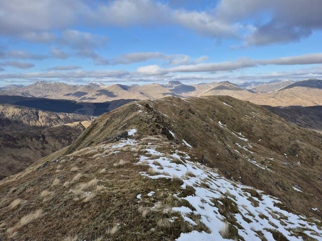
Braigh nan Uamhachan — "the brae of the little caves" — is a 765m Corbett north of Glenfinnan in the wild country between Loch Eilt and Loch Arkaig. The hill is a long ridge of grass and rock with several small bumps along its 3km crest. The summit is a rocky outcrop with views west to the Rough Bounds, north into the Loch Arkaig forest, and south down Loch Eilt to the Sound of Arisaig. Pairs naturally with Streap on the ridge to the south.
Quick facts
- Height
- 765m/ 2510ft
- Prominence
- 276 m
- Distance
- 14 km
- Ascent
- 627 m
- Time
- 4–7 hrs
- Grid ref
- NM975867
- Parking
- NM917800
- Nearest city
- Fort William· 18km
- Dogs
- Dogs on lead required near livestockDog-friendly guide ↗
Height and prominence cross-checked against the Database of British and Irish Hills (CC BY).
No GPX track yet
Walked this route? Share your track to help other walkers.
Standard route
glen track 25% · deep heather 45% · grassy upper slopes 20% · summit area 10%
Start from the lay-by on the A830 near Glenfinnan and follow the stalkers path north up the Allt na Cruaiche. After roughly 4km, climb pathless heather slopes west onto the broad south ridge of Braigh nan Uamhachan and follow it over several small tops to the summit outcrop. Around 14km return with 627m of ascent. Sometimes combined with Streap (its higher Corbett neighbour) for a long and demanding ridge traverse.
Terrain
The Allt na Cruaiche stalkers path is firm peat. Off the path the hillside is rough heather and grass — pathless and slow. The summit ridge is short heather and small rock outcrops; navigation across the several similar bumps demands attention in mist. No exposure on the standard line but the connecting ridge to Streap involves significant re-ascent.
In winter
A typical Lochaber west-coast winter Corbett — open ridge picks up full Atlantic loading, but no avalanche slopes on the standard line. The summit ridge cornices on its east side after south-westerly storms. The A830 is gritted and reliable. Bring full kit for the exposed ridge above 600m.
This hill is in the Glen Coe SAIS forecast area. Check SAIS forecasts in winter (December–April).
Best time of year
Getting there
- Glasgow3h 53m
- Edinburgh3h 17m
OS maps: OS Landranger 40
Mobile signal: Intermittent on the A830 corridor; blank on the upper hill
Current conditions
Daylight Today
- Sunrise
- 04:47
- Sunset
- 22:08
- Civil dawn
- 03:46
- Civil dusk
- 23:08
NOAA Solar Calculator · 13 July 2026
Pair with
Curated multi-hill combinations from Braigh nan Uamhachan.
Around Braigh nan Uamhachan on the SCOT network
Getting there, basing yourself, and what to do off the hill.
Getting there: Glenfinnan station
Glenfinnan Viaduct; Streap, Sgurr Thuilm, Glen Finnan Munros
9km from the hill
tripscot.co.uk
On TripSCOTBase yourself in Fort William
Ben Nevis base, West Highland Line, gateway to Lochaber
18km from the hill
tripscot.co.uk
On TasteSCOTAfter the hill: Ben Nevis Distillery
Fort William — Lochaber distillery at the foot of the Ben; long-aged Japanese-owned classics
18km from the hill
tastescot.co.uk
Braigh nan Uamhachan — common questions
- What difficulty is Braigh nan Uamhachan?
- On the OutdoorSCOT scale, Braigh nan Uamhachan comes in at 2/5 — moderate. Expect roughly 14km and 627m of ascent on the usual route — 4-7 hours for most parties. Ground conditions: The Allt na Cruaiche stalkers path is firm peat.
- How much drop does Braigh nan Uamhachan have?
- The drop is 276m: measured from the summit of Braigh nan Uamhachan down to the saddle joining it to higher terrain.
- Where's the parking for Braigh nan Uamhachan?
- Park at NM917800. Double-check the grid reference on an OS map first; informal laybys here fill early in high season.
- What's the best month to climb Braigh nan Uamhachan?
- Aim for May, June, July, August, September on Braigh nan Uamhachan. In the remaining months treat it as a winter hill — full kit, solid navigation, and a look at the relevant SAIS avalanche forecast before you go.
- Can dogs go up Braigh nan Uamhachan?
- Dogs are fine on a lead. The route passes livestock or ground-nesting bird habitat, so keep them close throughout.
- Will I get phone signal on Braigh nan Uamhachan?
- Intermittent on the A830 corridor; blank on the upper hill
- Is Braigh nan Uamhachan safe in winter?
- A typical Lochaber west-coast winter Corbett — open ridge picks up full Atlantic loading, but no avalanche slopes on the standard line. The summit ridge cornices on its east side after south-westerly storms. The A830 is gritted and reliable. Bring full kit for the exposed ridge above 600m.
Get the OutdoorSCOT weekly
One email a week — new route, hill and bothy guides, seasonal conditions and the odd hard-won lesson. No spam, unsubscribe in one click.