Graham · Glen Coe & Lochaber
Meall Onfhaidh
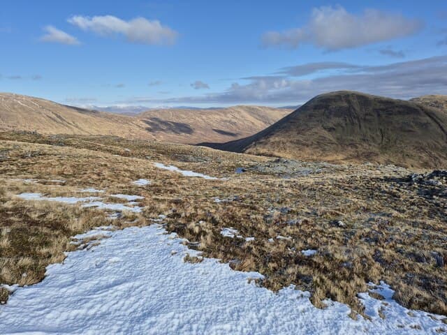
Meall Onfhaidh (679m) lies above the south shore of Loch Arkaig in NN08, a quiet Lochaber Graham whose name carries the sense of storm or commotion — apt for an exposed top often the first to catch westerly squalls running up the loch. From the summit rock the eye runs over Loch Arkaig to the Knoydart Munros and south to the bulk of Gulvain.
Quick facts
- Height
- 679.3m/ 2229ft
- Prominence
- 297 m
- Distance
- 13 km
- Ascent
- 557 m
- Time
- 4–6 hrs
- Grid ref
- NN010840
- Parking
- NN018849
- Nearest city
- Fort William· 14km
- Dogs
- Dogs on lead required near livestockDog-friendly guide ↗
Height and prominence cross-checked against the Database of British and Irish Hills (CC BY).
No GPX track yet
Walked this route? Share your track to help other walkers.
Standard route
heather moorland 65% · grass slopes 25% · rocky summit 10%
Park at the Eas Chia-aig falls car park beside Loch Arkaig. Follow the forest road up Gleann Cia-aig for around 3km, then break off west on a clearing line through plantation onto open hillside near 350m. Climb the east shoulder on heather and bilberry to gain the broad summit ridge, with the top marked by a small rock perched above the southern crag.
Terrain
Forest road then plantation edge to access the open hill, with windthrow and deep brash at the treeline often forcing a detour. Above the forest, heather and grass cover the east shoulder cleanly. The summit crest is broad and unhurried with a small drop on the south side.
In winter
Loch Arkaig sees serious snowfall in west-coast cold spells and the south face of Meall Onfhaidh holds drifted snow into April. Cornicing on the south-facing crag is the main hazard. SAIS Lochaber forecasts apply for the wider area, though the gentle east shoulder rarely carries serious avalanche risk.
This hill is in the Glen Coe SAIS forecast area. Check SAIS forecasts in winter (December–April).
Best time of year
Getting there
- Glasgow3h 48m
- Edinburgh3h 12m
OS maps: OS Landranger 41
Mobile signal: Weak. Remote Strathconon; thin on most networks.
Current conditions
Daylight Today
- Sunrise
- 04:53
- Sunset
- 22:02
- Civil dawn
- 03:54
- Civil dusk
- 23:00
NOAA Solar Calculator · 17 July 2026
Around Meall Onfhaidh on the SCOT network
Getting there, basing yourself, and what to do off the hill.
Getting there: Glenfinnan station
Glenfinnan Viaduct; Streap, Sgurr Thuilm, Glen Finnan Munros
11km from the hill
tripscot.co.uk
On TripSCOTBase yourself in Fort William
Ben Nevis base, West Highland Line, gateway to Lochaber
14km from the hill
tripscot.co.uk
On TasteSCOTAfter the hill: Ben Nevis Distillery
Fort William — Lochaber distillery at the foot of the Ben; long-aged Japanese-owned classics
14km from the hill
tastescot.co.uk
Meall Onfhaidh — common questions
- How hard is Meall Onfhaidh?
- We grade Meall Onfhaidh at 4/5, which puts it in challenging territory. The usual route is around 13km with 557m of climbing; allow 4-6 hours. Ground conditions: Forest road then plantation edge to access the open hill, with windthrow and deep brash at the treeline often forcing a detour.
- How much drop does Meall Onfhaidh have?
- The drop is 297m: measured from the summit of Meall Onfhaidh down to the saddle joining it to higher terrain.
- Where's the parking for Meall Onfhaidh?
- Park at NN018849. Double-check the grid reference on an OS map first; informal laybys here fill early in high season.
- What's the best month to climb Meall Onfhaidh?
- Aim for March, April, May, June, July, August, September, October, November on Meall Onfhaidh. In the remaining months treat it as a winter hill — full kit, solid navigation, and a look at the relevant SAIS avalanche forecast before you go.
- Can dogs go up Meall Onfhaidh?
- Dogs are fine on a lead. The route passes livestock or ground-nesting bird habitat, so keep them close throughout.
- Will I get phone signal on Meall Onfhaidh?
- Weak. Remote Strathconon; thin on most networks.
- Is Meall Onfhaidh safe in winter?
- Loch Arkaig sees serious snowfall in west-coast cold spells and the south face of Meall Onfhaidh holds drifted snow into April. Cornicing on the south-facing crag is the main hazard. SAIS Lochaber forecasts apply for the wider area, though the gentle east shoulder rarely carries serious avalanche risk.
Get the OutdoorSCOT weekly
One email a week — new route, hill and bothy guides, seasonal conditions and the odd hard-won lesson. No spam, unsubscribe in one click.