Graham · Glen Coe & Lochaber
Mullach Coire nan Geur-oirean
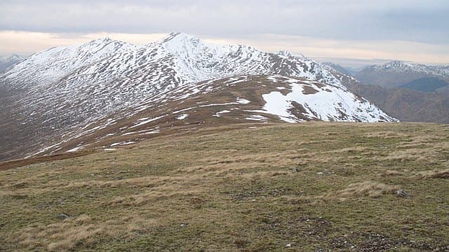
A remote Graham on the south side of Loch Arkaig, deep in the Locheil Forest. One of the hardest Grahams to reach in southern Lochaber — the walk-in along the loch is the main commitment.
Gaelic: “summit, corrie, of the” · Pronunciation: mull-ach kor-a nan geur oirean
Quick facts
- Height
- 727m/ 2385ft
- Prominence
- 191 m
- Distance
- 13 km
- Ascent
- 596 m
- Time
- 4–6 hrs
- Grid ref
- NN049892
- Parking
- NN024884
- Nearest city
- Fort William· 16km
- Dogs
- Dogs on lead required near livestockDog-friendly guide ↗
Height and prominence cross-checked against the Database of British and Irish Hills (CC BY).
No GPX track yet
Walked this route? Share your track to help other walkers.
Standard route
loch path 20% · rough heather 45% · grassy upper slopes 25% · summit area 10%
Drive to the road end at the west end of Loch Arkaig (Strathan). Follow the estate track east along the south shore for several kilometres, then climb steeply south on the heather flanks to gain the summit ridge.
Terrain
Tarmac road, then estate track, then trackless steep heather and bracken. The summit ridge is grass and small outcrops. Long flat walking before any real climbing starts.
In winter
The Loch Arkaig road is unploughed in winter and can be impassable. From Strathan the going is undemanding but the daylight window is tight — most parties bivvy or use the Strathan bothy.
This hill is in the Glen Coe SAIS forecast area. Check SAIS forecasts in winter (December–April).
Best time of year
Getting there
- Glasgow3h 52m
- Edinburgh3h 12m
OS maps: OS Landranger 41
Mobile signal: Reception fades west of Achnacarry; nothing at Strathan
Current conditions
Daylight Today
- Sunrise
- 04:52
- Sunset
- 22:02
- Civil dawn
- 03:53
- Civil dusk
- 23:01
NOAA Solar Calculator · 17 July 2026
Around Mullach Coire nan Geur-oirean on the SCOT network
Getting there, basing yourself, and what to do off the hill.
Getting there: Banavie station
Neptune's Staircase; alternate Fort William access; Great Glen Way
14km from the hill
tripscot.co.uk
On TripSCOTBase yourself in Fort William
Ben Nevis base, West Highland Line, gateway to Lochaber
16km from the hill
tripscot.co.uk
On TasteSCOTAfter the hill: Ben Nevis Distillery
Fort William — Lochaber distillery at the foot of the Ben; long-aged Japanese-owned classics
15km from the hill
tastescot.co.uk
Mullach Coire nan Geur-oirean — common questions
- What difficulty is Mullach Coire nan Geur-oirean?
- On the OutdoorSCOT scale, Mullach Coire nan Geur-oirean comes in at 4/5 — challenging. Expect roughly 13km and 596m of ascent on the usual route — 4-6 hours for most parties. Terrain: Tarmac road, then estate track, then trackless steep heather and bracken.
- How prominent is Mullach Coire nan Geur-oirean?
- Mullach Coire nan Geur-oirean has 191m of topographic prominence — the height of its summit above the highest col connecting it to higher ground.
- Where should I park to climb Mullach Coire nan Geur-oirean?
- Standard parking is at NN024884. Check the parking grid reference on an OS map before travel; informal laybys can fill on summer weekends.
- When should I climb Mullach Coire nan Geur-oirean?
- The standard good-weather months for Mullach Coire nan Geur-oirean are April, May, June, July, August, September, October. Outside those months, expect winter conditions on the high ground — full mountain kit, navigation skills, and a check of the SAIS avalanche forecast for the relevant region.
- Can I bring my dog up Mullach Coire nan Geur-oirean?
- On a lead only — the route crosses ground with livestock or nesting-bird interest.
- What's mobile reception like on Mullach Coire nan Geur-oirean?
- Reception fades west of Achnacarry; nothing at Strathan
- Is Mullach Coire nan Geur-oirean safe in winter?
- The Loch Arkaig road is unploughed in winter and can be impassable. From Strathan the going is undemanding but the daylight window is tight — most parties bivvy or use the Strathan bothy.
Get the OutdoorSCOT weekly
One email a week — new route, hill and bothy guides, seasonal conditions and the odd hard-won lesson. No spam, unsubscribe in one click.