Graham · Kintail
Meall Blair
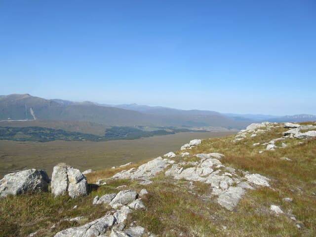
Meall Blair (656m) — the moor hill — rises above the Mile Dorcha section of Loch Arkaig in the NN09 square. A small trig point sits on a clipped grassy dome looking south-west down Glen Mallie and north over the dark waters of Loch Arkaig toward the Munros of Glen Dessarry.
Quick facts
- Height
- 656.5m/ 2154ft
- Prominence
- 213 m
- Distance
- 13 km
- Ascent
- 538 m
- Time
- 4–6 hrs
- Grid ref
- NN077950
- Parking
- NN148889
- Nearest city
- Fort William· 21km
- Dogs
- Dogs on lead required near livestockDog-friendly guide ↗
Height and prominence cross-checked against the Database of British and Irish Hills (CC BY).
No GPX track yet
Walked this route? Share your track to help other walkers.
Standard route
heather moorland 60% · grass slopes 30% · rocky summit 10%
Start from the parking at the east end of Loch Arkaig at Achnasaul. Follow the forest road west for two kilometres before turning south on a firebreak that climbs onto open ground. A pathless heather pull south-east leads onto the grassy crown of the dome where the trig stands well above the loch.
Terrain
Forest road and firebreak combine for the lower stages — well graded but muddy in places. Above the trees, deep heather and an occasional deer trod lead onto the closely cropped summit dome. The trig is on a small platform of grass and gravel.
In winter
Loch Arkaig sees marine snowfall that turns the heather to porridge after thaws. Meall Blair's gentle dome rarely holds avalanche-grade snow but the firebreak can be choked by drifts. The forest provides good shelter on a wild day and the trig is a clear navigational target.
Best time of year
Getting there
- Glasgow3h 58m
- Edinburgh3h 15m
OS maps: OS Landranger 33
Mobile signal: Poor. Remote Loch Arkaig / Glen Mallie area; weak on most networks.
Current conditions
Daylight Today
- Sunrise
- 04:45
- Sunset
- 22:08
- Civil dawn
- 03:44
- Civil dusk
- 23:09
NOAA Solar Calculator · 13 July 2026
Around Meall Blair on the SCOT network
Getting there, basing yourself, and what to do off the hill.
Getting there: Banavie station
Neptune's Staircase; alternate Fort William access; Great Glen Way
19km from the hill
tripscot.co.uk
On TripSCOTBase yourself in Fort William
Ben Nevis base, West Highland Line, gateway to Lochaber
21km from the hill
tripscot.co.uk
On TasteSCOTAfter the hill: Ben Nevis Distillery
Fort William — Lochaber distillery at the foot of the Ben; long-aged Japanese-owned classics
19km from the hill
tastescot.co.uk
Meall Blair — common questions
- How difficult is Meall Blair?
- Meall Blair carries a 4/5 (challenging) grade on the OutdoorSCOT scale. Count on about 13km, 538m of ascent and a 4-6 hour day on the standard route. Underfoot: Forest road and firebreak combine for the lower stages — well graded but muddy in places.
- What is Meall Blair's prominence?
- 213m of prominence. That's the vertical drop from the summit to the col that links Meall Blair to the next higher ground.
- Where do I park for Meall Blair?
- Most walkers start from NN148889. Verify the grid reference on an OS map before you set off — space is tight on busy summer weekends.
- When is the best time to climb Meall Blair?
- March, April, May, June, July, August, September, October, November give the most reliable conditions on Meall Blair. Beyond that window the high ground turns wintry: carry full mountain kit, be confident navigating, and check the SAIS avalanche forecast for the area.
- Is Meall Blair dog-friendly?
- Yes, but dogs must be kept on a lead — there is livestock or ground-nesting bird interest on the route.
- Is there mobile signal on Meall Blair?
- Poor. Remote Loch Arkaig / Glen Mallie area; weak on most networks.
- Is Meall Blair safe in winter?
- Loch Arkaig sees marine snowfall that turns the heather to porridge after thaws. Meall Blair's gentle dome rarely holds avalanche-grade snow but the firebreak can be choked by drifts. The forest provides good shelter on a wild day and the trig is a clear navigational target.
Get the OutdoorSCOT weekly
One email a week — new route, hill and bothy guides, seasonal conditions and the odd hard-won lesson. No spam, unsubscribe in one click.