Graham · Glen Coe & Lochaber
Druim Fada
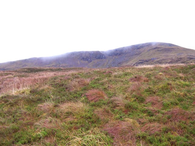
A long whaleback ridge running parallel to the north shore of Loch Eil, looking south to Ben Nevis and the Mamores across the head of Loch Linnhe. The traverse from end to end gives one of the best low-level Lochaber ridge walks anywhere.
Gaelic: “ridge, long” · Pronunciation: drim fah-dah
Quick facts
- Height
- 742.9m/ 2437ft
- Prominence
- 517 m
- Distance
- 14 km
- Ascent
- 608 m
- Time
- 4–7 hrs
- Grid ref
- NN087823
- Parking
- NN022787
- Nearest city
- Fort William· 9km
- Dogs
- Dogs on lead required near livestockDog-friendly guide ↗
Height and prominence cross-checked against the Database of British and Irish Hills (CC BY).
No GPX track yet
Walked this route? Share your track to help other walkers.
Standard route
loch-side path 25% · heather hillside 40% · grassy ridge 25% · summit area 10%
Park near Fassfern at the road end and gain the ridge via the steep south flank above the forestry, then walk west along the broad crest to Stob a' Ghrianain at the high point before retracing or descending east toward Annat.
Terrain
Steep forestry tracks to gain the ridge, then mostly grassy walking on a broad crest with occasional outcrops. A long up-and-down profile rather than continuous climb.
In winter
Low-lying ridge that catches the worst of Atlantic frontal weather; the crest stays clear of snow most years but the steep north flank holds windslab in long northerly spells. Lochaber SAIS region applies.
This hill is in the Glen Coe SAIS forecast area. Check SAIS forecasts in winter (December–April).
Best time of year
Getting there
- Glasgow3h 42m
- Edinburgh3h 4m
OS maps: OS Landranger 41, OS Explorer 391
Mobile signal: No coverage in this remote Glen Garry area
Current conditions
Daylight Today
- Sunrise
- 04:46
- Sunset
- 22:07
- Civil dawn
- 03:45
- Civil dusk
- 23:07
NOAA Solar Calculator · 13 July 2026
Pair with
Curated multi-hill combinations from Druim Fada.
Around Druim Fada on the SCOT network
Getting there, basing yourself, and what to do off the hill.
Getting there: Banavie station
Neptune's Staircase; alternate Fort William access; Great Glen Way
6km from the hill
tripscot.co.uk
On TripSCOTBase yourself in Fort William
Ben Nevis base, West Highland Line, gateway to Lochaber
9km from the hill
tripscot.co.uk
On TasteSCOTAfter the hill: Ben Nevis Distillery
Fort William — Lochaber distillery at the foot of the Ben; long-aged Japanese-owned classics
7km from the hill
tastescot.co.uk
Druim Fada — common questions
- What difficulty is Druim Fada?
- On the OutdoorSCOT scale, Druim Fada comes in at 4/5 — challenging. Expect roughly 14km and 608m of ascent on the usual route — 4-7 hours for most parties. Ground conditions: Steep forestry tracks to gain the ridge, then mostly grassy walking on a broad crest with occasional outcrops.
- How much drop does Druim Fada have?
- The drop is 517m: measured from the summit of Druim Fada down to the saddle joining it to higher terrain.
- Where's the parking for Druim Fada?
- Park at NN022787. Double-check the grid reference on an OS map first; informal laybys here fill early in high season.
- What's the best month to climb Druim Fada?
- Aim for April, May, June, July, August, September, October on Druim Fada. In the remaining months treat it as a winter hill — full kit, solid navigation, and a look at the relevant SAIS avalanche forecast before you go.
- Can dogs go up Druim Fada?
- Dogs are fine on a lead. The route passes livestock or ground-nesting bird habitat, so keep them close throughout.
- Will I get phone signal on Druim Fada?
- No coverage in this remote Glen Garry area
- Is Druim Fada safe in winter?
- Low-lying ridge that catches the worst of Atlantic frontal weather; the crest stays clear of snow most years but the steep north flank holds windslab in long northerly spells. Lochaber SAIS region applies.
Get the OutdoorSCOT weekly
One email a week — new route, hill and bothy guides, seasonal conditions and the odd hard-won lesson. No spam, unsubscribe in one click.