Graham · Glen Coe & Lochaber
Aodann Chleireig
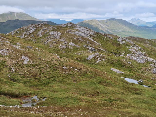
Aodann Chleireig (662m) — the cleric's face — sits above the Cona Glen in the NM98 square south of Loch Eil. Its rocky outcrop summit looks across to the Streaps and Sgurr Thuilm, with the Corran Narrows visible to the south on a clear day.
Quick facts
- Height
- 662.6m/ 2174ft
- Prominence
- 314 m
- Distance
- 13 km
- Ascent
- 543 m
- Time
- 4–6 hrs
- Grid ref
- NM994825
- Parking
- NN001836
- Nearest city
- Fort William· 14km
- Dogs
- Dogs on lead required near livestockDog-friendly guide ↗
Height and prominence cross-checked against the Database of British and Irish Hills (CC BY).
No GPX track yet
Walked this route? Share your track to help other walkers.
Standard route
heather and bog 60% · grass slopes 30% · rocky summit 10%
From the parking at Callop near the head of Loch Eil, cross the river and take the forestry track south-east into the lower Cona Glen. Leave the track at the bridge below the hill's west spur and climb directly through bracken and birch onto open hillside, finishing on a heathery shoulder to the outcrop.
Terrain
Forestry track and bridge for the first stage, then steep bracken and rough birch slopes on the west spur. Above the woodland, heather and quartzite outcrops lead in stages to the open top — easy enough in clear weather, awkward in mist.
In winter
The hill faces directly into Atlantic fronts and snow at this altitude is wet and consolidates quickly. Wind slab can form on the lee east flank toward Cona Glen. SAIS West Highlands covers the area and is worth checking for any visit above 500m between January and April.
This hill is in the Glen Coe SAIS forecast area. Check SAIS forecasts in winter (December–April).
Best time of year
Getting there
- Glasgow3h 48m
- Edinburgh3h 12m
OS maps: OS Landranger 40
Mobile signal: Poor. Remote Cona Glen / Loch Eil south shore; faint on most networks.
Current conditions
Daylight Today
- Sunrise
- 04:53
- Sunset
- 22:02
- Civil dawn
- 03:54
- Civil dusk
- 23:00
NOAA Solar Calculator · 17 July 2026
Around Aodann Chleireig on the SCOT network
Getting there, basing yourself, and what to do off the hill.
Getting there: Glenfinnan station
Glenfinnan Viaduct; Streap, Sgurr Thuilm, Glen Finnan Munros
9km from the hill
tripscot.co.uk
On TripSCOTBase yourself in Fort William
Ben Nevis base, West Highland Line, gateway to Lochaber
14km from the hill
tripscot.co.uk
On TasteSCOTAfter the hill: Ben Nevis Distillery
Fort William — Lochaber distillery at the foot of the Ben; long-aged Japanese-owned classics
14km from the hill
tastescot.co.uk
Aodann Chleireig — common questions
- What difficulty is Aodann Chleireig?
- On the OutdoorSCOT scale, Aodann Chleireig comes in at 4/5 — challenging. Expect roughly 13km and 543m of ascent on the usual route — 4-6 hours for most parties. Terrain: Forestry track and bridge for the first stage, then steep bracken and rough birch slopes on the west spur.
- How prominent is Aodann Chleireig?
- Aodann Chleireig has 314m of topographic prominence — the height of its summit above the highest col connecting it to higher ground.
- Where should I park to climb Aodann Chleireig?
- Standard parking is at NN001836. Check the parking grid reference on an OS map before travel; informal laybys can fill on summer weekends.
- When should I climb Aodann Chleireig?
- The standard good-weather months for Aodann Chleireig are March, April, May, June, July, August, September, October, November. Outside those months, expect winter conditions on the high ground — full mountain kit, navigation skills, and a check of the SAIS avalanche forecast for the relevant region.
- Can I bring my dog up Aodann Chleireig?
- On a lead only — the route crosses ground with livestock or nesting-bird interest.
- What's mobile reception like on Aodann Chleireig?
- Poor. Remote Cona Glen / Loch Eil south shore; faint on most networks.
- Is Aodann Chleireig safe in winter?
- The hill faces directly into Atlantic fronts and snow at this altitude is wet and consolidates quickly. Wind slab can form on the lee east flank toward Cona Glen. SAIS West Highlands covers the area and is worth checking for any visit above 500m between January and April.
Get the OutdoorSCOT weekly
One email a week — new route, hill and bothy guides, seasonal conditions and the odd hard-won lesson. No spam, unsubscribe in one click.