Corbett · Glenfinnan
Streap
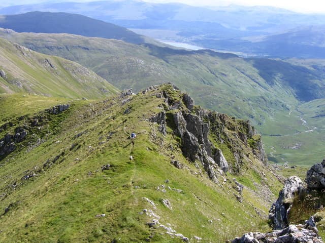
Streap is the sharp pointed Corbett rising behind the Glenfinnan Munros, and probably the finest narrow ridge in the western Highlands outside the Cuillin. The name is from the Gaelic for 'climbing' and it earns it — the upper ridge is genuinely knife-edged with serious drops on both sides. At 909m it falls just short of Munro status, and the lack of crowds is one of its quiet pleasures. The summit is a tiny pyramid with views across to Sgurr Thuilm, Sgurr nan Coireachan and the long line of the Glenfinnan ridge.
Quick facts
- Height
- 909m/ 2982ft
- Prominence
- 438 m
- Distance
- 18 km
- Ascent
- 1100 m
- Time
- 6–9 hrs
- Grid ref
- NM946863
- Parking
- NM906808
- Nearest city
- Fort William· 20km
- Dogs
- Dogs on lead required near livestockDog-friendly guide ↗
Height and prominence cross-checked against the Database of British and Irish Hills (CC BY).
No GPX track yet
Walked this route? Share your track to help other walkers.
Standard route
glen path 20% · steep grass 30% · rocky scramble 35% · summit pinnacle 15%
Most parties start from Glenfinnan, walking up the estate road north of the viaduct for around 4km, then turning west into Coire Chicheanais. The path climbs to the bealach between Streap and Streap Comhlaidh, then takes the narrow south-east ridge to the summit. The descent is usually a reverse of the ascent — the alternative north-west ridge to Stob Coire nan Cearc is sustained Grade 2 scrambling and committing in poor conditions. Allow 7–8 hours.
Terrain
The walk-in along the Glenfinnan estate road is straightforward but adds distance at both ends. Above the bealach the ridge narrows quickly — turf-and-rock crest with a true knife-edge feel on the final section to the summit. The descent line off the south-east ridge is steep and grassy; in the wet it is slippery enough to need care.
In winter
Streap's narrow ridge becomes a serious winter mountaineering route under snow. Cornices form on the east side of the crest and the line of the path is buried. The steep south-eastern flank is classic windslab territory after a south-westerly storm; the daily Lochaber SAIS bulletin should be read before committing. In firm winter conditions it is an outstanding ridge; in soft snow or thaw it is treacherous.
This hill is in the Glen Coe SAIS forecast area. Check SAIS forecasts in winter (December–April).
Best time of year
Getting there
- Glasgow3h 55m
- Edinburgh3h 19m
OS maps: OS Landranger 40
Mobile signal: No signal on the hill itself; intermittent EE/Vodafone near the Glenfinnan viaduct and visitor centre
Current conditions
Daylight Today
- Sunrise
- 04:47
- Sunset
- 22:08
- Civil dawn
- 03:46
- Civil dusk
- 23:08
NOAA Solar Calculator · 13 July 2026
Pair with
Curated multi-hill combinations from Streap.
Around Streap on the SCOT network
Getting there, basing yourself, and what to do off the hill.
Getting there: Glenfinnan station
Glenfinnan Viaduct; Streap, Sgurr Thuilm, Glen Finnan Munros
7km from the hill
tripscot.co.uk
On TripSCOTBase yourself in Fort William
Ben Nevis base, West Highland Line, gateway to Lochaber
20km from the hill
tripscot.co.uk
On TasteSCOTAfter the hill: Ben Nevis Distillery
Fort William — Lochaber distillery at the foot of the Ben; long-aged Japanese-owned classics
20km from the hill
tastescot.co.uk
Streap — common questions
- Is Streap a hard climb?
- Streap is rated 4/5 (challenging) on the OutdoorSCOT scale. The standard route covers about 18km with 1100m of ascent and takes most walkers 6-9 hours. Ground conditions: The walk-in along the Glenfinnan estate road is straightforward but adds distance at both ends.
- How much drop does Streap have?
- The drop is 438m: measured from the summit of Streap down to the saddle joining it to higher terrain.
- Where's the parking for Streap?
- Park at NM906808. Double-check the grid reference on an OS map first; informal laybys here fill early in high season.
- What's the best month to climb Streap?
- Aim for May, June, July, August, September on Streap. In the remaining months treat it as a winter hill — full kit, solid navigation, and a look at the relevant SAIS avalanche forecast before you go.
- Can dogs go up Streap?
- Dogs are fine on a lead. The route passes livestock or ground-nesting bird habitat, so keep them close throughout.
- Will I get phone signal on Streap?
- No signal on the hill itself; intermittent EE/Vodafone near the Glenfinnan viaduct and visitor centre
- Is Streap safe in winter?
- Streap's narrow ridge becomes a serious winter mountaineering route under snow. Cornices form on the east side of the crest and the line of the path is buried. The steep south-eastern flank is classic windslab territory after a south-westerly storm; the daily Lochaber SAIS bulletin should be read before committing. In firm winter conditions it is an outstanding ridge; in soft snow or thaw it is treacherous.
Get the OutdoorSCOT weekly
One email a week — new route, hill and bothy guides, seasonal conditions and the odd hard-won lesson. No spam, unsubscribe in one click.