Graham · Moidart
An Stac
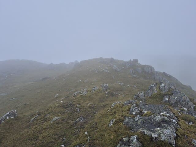
An Stac (717m) — the stack — is a steep-sided peak at NM86 north of Loch Eilt, set between the Rois-Bheinn group to the west and Sgurr Thuilm to the east. Its name reflects the conical profile when seen from the A830 Mallaig road. Two prominent boulders mark the airy summit, which looks out over Loch Beoraid in deep shadow below, the islands of Eigg and Rum out west, and the Glenfinnan Munros stacked to the north-east.
Quick facts
- Height
- 717.8m/ 2355ft
- Prominence
- 223 m
- Distance
- 13 km
- Ascent
- 588 m
- Time
- 4–6 hrs
- Grid ref
- NM866889
- Parking
- NM875883
- Nearest city
- Fort William· 28km
- Dogs
- Dogs on lead required near livestockDog-friendly guide ↗
Height and prominence cross-checked against the Database of British and Irish Hills (CC BY).
No GPX track yet
Walked this route? Share your track to help other walkers.
Standard route
bracken approach 25% · steep grass 45% · rocky bluffs 20% · summit dome 10%
Park near the Polnish telephone box on the A830 (NM875883). Cross the road and climb directly up the steep south-west face on faint deer trods, gaining height fast through bracken and rocky bluffs onto the upper grass dome. Around 13km on the round; 588m of ascent — short in distance but committing in gradient. Descent best by the same line or by traversing south-east to drop into Glen Beoraid for a longer return.
Terrain
Lower bracken is thick and conceals boulders in summer — long trousers help. Above 400m the slope steepens with rock bands that can be threaded on grass rakes; no scrambling required if a careful line is chosen. The summit twin-boulder cairn area is small but unmistakable.
In winter
Steep south-west and east faces hold windslab after westerly storms — the Lochaber SAIS region is the best reference even though the hill sits just outside the standard forecast boundary. Iced bracken stems on the lower slopes cause more turned ankles in winter than the rocks above. December daylight here drops below seven hours.
This hill is in the Glen Coe SAIS forecast area. Check SAIS forecasts in winter (December–April).
Best time of year
Getting there
- Glasgow3h 3m
- Edinburgh3h 28m
OS maps: OS Landranger 40
Mobile signal: Intermittent on the A830 corridor; signal drops on the climb
Current conditions
Daylight Today
- Sunrise
- 04:47
- Sunset
- 22:08
- Civil dawn
- 03:46
- Civil dusk
- 23:09
NOAA Solar Calculator · 13 July 2026
Around An Stac on the SCOT network
Getting there, basing yourself, and what to do off the hill.
Getting there: Glenfinnan station
Glenfinnan Viaduct; Streap, Sgurr Thuilm, Glen Finnan Munros
9km from the hill
tripscot.co.uk
On TripSCOTBase yourself in Mallaig
Ferry port for Skye and the Small Isles; CWT finish supply
20km from the hill
tripscot.co.uk
On TasteSCOTAfter the hill: Ben Nevis Distillery
Fort William — Lochaber distillery at the foot of the Ben; long-aged Japanese-owned classics
29km from the hill
tastescot.co.uk
An Stac — common questions
- Is An Stac a hard climb?
- An Stac is rated 2/5 (moderate) on the OutdoorSCOT scale. The standard route covers about 13km with 588m of ascent and takes most walkers 4-6 hours. Underfoot: Lower bracken is thick and conceals boulders in summer — long trousers help.
- What is An Stac's prominence?
- 223m of prominence. That's the vertical drop from the summit to the col that links An Stac to the next higher ground.
- Where do I park for An Stac?
- Most walkers start from NM875883. Verify the grid reference on an OS map before you set off — space is tight on busy summer weekends.
- When is the best time to climb An Stac?
- May, June, July, August, September give the most reliable conditions on An Stac. Beyond that window the high ground turns wintry: carry full mountain kit, be confident navigating, and check the SAIS avalanche forecast for the area.
- Is An Stac dog-friendly?
- Yes, but dogs must be kept on a lead — there is livestock or ground-nesting bird interest on the route.
- Is there mobile signal on An Stac?
- Intermittent on the A830 corridor; signal drops on the climb
- Is An Stac safe in winter?
- Steep south-west and east faces hold windslab after westerly storms — the Lochaber SAIS region is the best reference even though the hill sits just outside the standard forecast boundary. Iced bracken stems on the lower slopes cause more turned ankles in winter than the rocks above. December daylight here drops below seven hours.
Get the OutdoorSCOT weekly
One email a week — new route, hill and bothy guides, seasonal conditions and the odd hard-won lesson. No spam, unsubscribe in one click.