Graham · Glen Coe & Lochaber
Meith Bheinn
Meith Bheinn (710m) — the boggy hill — stands at NM82 on the south shore of Loch Morar, Britain's deepest freshwater loch. With Loch Nevis on its far side and Knoydart's rough country to the north, the hill is set in one of mainland Scotland's wildest sea-loch landscapes. The rock-marked summit overlooks the freshwater-to-saltwater isthmus at Tarbet — only a quarter-mile of land separates the two great lochs here.
Quick facts
- Height
- 710m/ 2329ft
- Prominence
- 325 m
- Distance
- 13 km
- Ascent
- 582 m
- Time
- 4–6 hrs
- Grid ref
- NM821872
- Parking
- NM840872
- Nearest city
- Fort William· 31km
- Dogs
- Dogs on lead required near livestockDog-friendly guide ↗
Height and prominence cross-checked against the Database of British and Irish Hills (CC BY).
No GPX track yet
Walked this route? Share your track to help other walkers.
Standard route
heather and bog 55% · rocky hillside 30% · coastal grass 15%
No road access — Loch Morar is reached on foot from Bracora at the west end (a long bog-trot) or by boat to Tarbet. The standard ascent climbs north-east from Tarbet via Bealach an Easain Duibh onto the broad east ridge. 13km on the upland section with 582m of climbing; the boat-in adds a logistical layer many parties enjoy.
Terrain
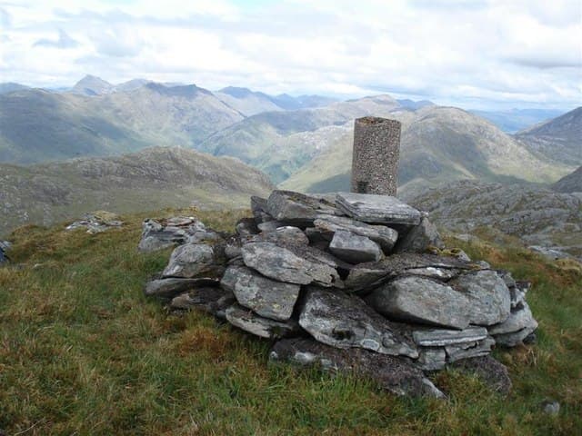
Pathless throughout above the loch shore. Sphagnum and tussock-grass on the lower slopes — the name is well chosen. Above 500m the going firms onto Lewisian gneiss outcrops with grass between. The summit boulder sits on a small flat shelf giving the cardinal points of the long ridge.
In winter
Loch Morar's humid maritime air promotes rapid rime accretion and verglas on every rock face. The Lochaber SAIS region applies. Logistics are the real winter problem — boat service to Tarbet is uncertain in storms, leaving the long Bracora approach as the only alternative. Daylight is below seven hours here in December.
This hill is in the Glen Coe SAIS forecast area. Check SAIS forecasts in winter (December–April).
Best time of year
Getting there
- Glasgow3h 4m
- Edinburgh4h 31m
OS maps: OS Landranger 40
Mobile signal: Poor. Remote position on Loch Morar shore — satellite communicator recommended.
Current conditions
Daylight Today
- Sunrise
- 04:48
- Sunset
- 22:09
- Civil dawn
- 03:47
- Civil dusk
- 23:09
NOAA Solar Calculator · 13 July 2026
Around Meith Bheinn on the SCOT network
Getting there, basing yourself, and what to do off the hill.
Meith Bheinn — common questions
- What difficulty is Meith Bheinn?
- On the OutdoorSCOT scale, Meith Bheinn comes in at 4/5 — challenging. Expect roughly 13km and 582m of ascent on the usual route — 4-6 hours for most parties. Terrain: Pathless throughout above the loch shore.
- How prominent is Meith Bheinn?
- Meith Bheinn has 325m of topographic prominence — the height of its summit above the highest col connecting it to higher ground.
- Where should I park to climb Meith Bheinn?
- Standard parking is at NM840872. Check the parking grid reference on an OS map before travel; informal laybys can fill on summer weekends.
- When should I climb Meith Bheinn?
- The standard good-weather months for Meith Bheinn are May, June, July, August, September. Outside those months, expect winter conditions on the high ground — full mountain kit, navigation skills, and a check of the SAIS avalanche forecast for the relevant region.
- Can I bring my dog up Meith Bheinn?
- On a lead only — the route crosses ground with livestock or nesting-bird interest.
- What's mobile reception like on Meith Bheinn?
- Poor. Remote position on Loch Morar shore — satellite communicator recommended.
- Is Meith Bheinn safe in winter?
- Loch Morar's humid maritime air promotes rapid rime accretion and verglas on every rock face. The Lochaber SAIS region applies. Logistics are the real winter problem — boat service to Tarbet is uncertain in storms, leaving the long Bracora approach as the only alternative. Daylight is below seven hours here in December.
Get the OutdoorSCOT weekly
One email a week — new route, hill and bothy guides, seasonal conditions and the odd hard-won lesson. No spam, unsubscribe in one click.