Graham · Glen Coe & Lochaber
Glas-charn
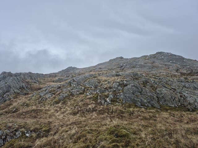
Glas-charn (633m), the green cairn, rises above Glenfinnan in the NM84 square at the head of Loch Shiel. The cairn perches on a grassy crown looking down the loch to the Moidart hills and across to the south Glenfinnan Munros. With the West Highland Line passing close to its base the hill has unusually easy public-transport access for a hill of this character.
Gaelic: “grey-green, cairn-topped hill” · Pronunciation: glass charn
Quick facts
- Height
- 633.3m/ 2078ft
- Prominence
- 329 m
- Distance
- 12 km
- Ascent
- 475 m
- Time
- 3–5 hrs
- Grid ref
- NM846837
- Parking
- NM864837
- Nearest city
- Fort William· 28km
- Dogs
- Dogs on lead required near livestockDog-friendly guide ↗
Height and prominence cross-checked against the Database of British and Irish Hills (CC BY).
No GPX track yet
Walked this route? Share your track to help other walkers.
Standard route
heather moorland 65% · grass and sedge 25% · rocky summit 10%
Park near Glenfinnan station at NM864837 and pick up the estate track up Coire Charnaig. The track climbs steadily before petering out on grassy slopes that lead onto the south ridge. The cairn is reached after a short but pleasant final pull. Total time around four to five hours, with the descent best taken on the same line to avoid steep ground falling east into the Lochan Dubha basin.
Terrain
A good landrover track gives most of the height-gain on firm ground. Above the track the south ridge is short grass over peat, drying out reasonably well in summer. The east face drops in tiers of broken crag — keep clear of it in poor visibility.
In winter
Glenfinnan funnels Atlantic moisture and Glas-charn often holds soft, wet snow on its upper grass. Verglas on the track in shaded sections is the most common hazard. The hill is short enough for a midwinter ascent if the weather is settled, but the east face cornices need respecting.
This hill is in the Glen Coe SAIS forecast area. Check SAIS forecasts in winter (December–April).
Best time of year
Getting there
- Glasgow3h 58m
- Edinburgh3h 26m
OS maps: OS Landranger 40
Mobile signal: Poor. Remote Cairngorms fringe; limited coverage on some networks.
Current conditions
Daylight Today
- Sunrise
- 04:48
- Sunset
- 22:08
- Civil dawn
- 03:47
- Civil dusk
- 23:09
NOAA Solar Calculator · 13 July 2026
Around Glas-charn on the SCOT network
Getting there, basing yourself, and what to do off the hill.
Getting there: Glenfinnan station
Glenfinnan Viaduct; Streap, Sgurr Thuilm, Glen Finnan Munros
7km from the hill
tripscot.co.uk
On TripSCOTBase yourself in Mallaig
Ferry port for Skye and the Small Isles; CWT finish supply
21km from the hill
tripscot.co.uk
On TasteSCOTAfter the hill: Ben Nevis Distillery
Fort William — Lochaber distillery at the foot of the Ben; long-aged Japanese-owned classics
29km from the hill
tastescot.co.uk
Glas-charn — common questions
- What difficulty is Glas-charn?
- On the OutdoorSCOT scale, Glas-charn comes in at 3/5 — moderately challenging. Expect roughly 12km and 475m of ascent on the usual route — 3-5 hours for most parties. Terrain: A good landrover track gives most of the height-gain on firm ground.
- How prominent is Glas-charn?
- Glas-charn has 329m of topographic prominence — the height of its summit above the highest col connecting it to higher ground.
- Where should I park to climb Glas-charn?
- Standard parking is at NM864837. Check the parking grid reference on an OS map before travel; informal laybys can fill on summer weekends.
- When should I climb Glas-charn?
- The standard good-weather months for Glas-charn are May, June, July, August, September. Outside those months, expect winter conditions on the high ground — full mountain kit, navigation skills, and a check of the SAIS avalanche forecast for the relevant region.
- Can I bring my dog up Glas-charn?
- On a lead only — the route crosses ground with livestock or nesting-bird interest.
- What's mobile reception like on Glas-charn?
- Poor. Remote Cairngorms fringe; limited coverage on some networks.
- Is Glas-charn safe in winter?
- Glenfinnan funnels Atlantic moisture and Glas-charn often holds soft, wet snow on its upper grass. Verglas on the track in shaded sections is the most common hazard. The hill is short enough for a midwinter ascent if the weather is settled, but the east face cornices need respecting.
Get the OutdoorSCOT weekly
One email a week — new route, hill and bothy guides, seasonal conditions and the odd hard-won lesson. No spam, unsubscribe in one click.