Graham · Glen Coe & Lochaber
Beinn Gaire
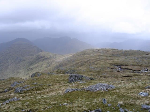
Beinn Gaire (666m) is a remote moorland peak in the Moidart hinterland of the NM77 square, set deep in the trackless country between Glenfinnan and Loch Shiel. Its 320m of re-ascent and the absence of paths make it one of the more committing Grahams of the west. The boulder cairn looks south over Loch Shiel to Beinn Resipol and west toward the Sound of Arisaig.
Quick facts
- Height
- 666.1m/ 2185ft
- Prominence
- 320 m
- Distance
- 13 km
- Ascent
- 546 m
- Time
- 4–6 hrs
- Grid ref
- NM781748
- Parking
- NM802776
- Nearest city
- Fort William· 32km
- Dogs
- Dogs on lead required near livestockDog-friendly guide ↗
Height and prominence cross-checked against the Database of British and Irish Hills (CC BY).
No GPX track yet
Walked this route? Share your track to help other walkers.
Standard route
heather and bog 65% · grass slopes 20% · rocky summit 15%
Start from the layby east of Glenfinnan on the A830 and follow the West Highland Line track south under the viaduct. A faint stalker rut climbs the long Allt na Cruaiche burn for several kilometres before fading on open moor. Strike west across rough ground onto the broad north-east shoulder and follow it to the boulder cairn — a long, lonely day of pathless travel.
Terrain
Wet moorland from the very first step, with deep bog and tussock that swallows daylight. The upper slopes firm up onto cropped grass and patches of mica-schist but the going is never quick. The summit cairn is set just beyond a small boulder — both deserve a touch.
In winter
Moidart winters bring relentless Atlantic rain interspersed with brief snow phases. Beinn Gaire holds drifted wet snow on its eastern flank and the long approach across frozen bog can actually be quicker in cold spells. SAIS does not cover Moidart — assume conditions similar to West Highland forecasts.
This hill is in the Glen Coe SAIS forecast area. Check SAIS forecasts in winter (December–April).
Best time of year
Getting there
- Glasgow3h 54m
- Edinburgh3h 26m
OS maps: OS Landranger 40
Mobile signal: Poor. Remote Morvern or Lochaber area; no reliable coverage.
Current conditions
Daylight Today
- Sunrise
- 04:55
- Sunset
- 22:03
- Civil dawn
- 03:57
- Civil dusk
- 23:01
NOAA Solar Calculator · 17 July 2026
Around Beinn Gaire on the SCOT network
Getting there, basing yourself, and what to do off the hill.
Beinn Gaire — common questions
- Is Beinn Gaire a hard climb?
- Beinn Gaire is rated 4/5 (challenging) on the OutdoorSCOT scale. The standard route covers about 13km with 546m of ascent and takes most walkers 4-6 hours. Ground conditions: Wet moorland from the very first step, with deep bog and tussock that swallows daylight.
- How much drop does Beinn Gaire have?
- The drop is 320m: measured from the summit of Beinn Gaire down to the saddle joining it to higher terrain.
- Where's the parking for Beinn Gaire?
- Park at NM802776. Double-check the grid reference on an OS map first; informal laybys here fill early in high season.
- What's the best month to climb Beinn Gaire?
- Aim for May, June, July, August, September on Beinn Gaire. In the remaining months treat it as a winter hill — full kit, solid navigation, and a look at the relevant SAIS avalanche forecast before you go.
- Can dogs go up Beinn Gaire?
- Dogs are fine on a lead. The route passes livestock or ground-nesting bird habitat, so keep them close throughout.
- Will I get phone signal on Beinn Gaire?
- Poor. Remote Morvern or Lochaber area; no reliable coverage.
- Is Beinn Gaire safe in winter?
- Moidart winters bring relentless Atlantic rain interspersed with brief snow phases. Beinn Gaire holds drifted wet snow on its eastern flank and the long approach across frozen bog can actually be quicker in cold spells. SAIS does not cover Moidart — assume conditions similar to West Highland forecasts.
Get the OutdoorSCOT weekly
One email a week — new route, hill and bothy guides, seasonal conditions and the odd hard-won lesson. No spam, unsubscribe in one click.