Corbett · Moidart
An Stac
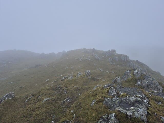
An Stac is the easternmost Corbett of the four-summit Rois-Bheinn ridge in Moidart, rising directly out of Loch Eilt between Lochailort and Glenfinnan. At 814m it is the lowest of the ridge's four tops but has its own striking rocky character — a sharp outcrop summit reached after a steep, exposed scramble from the connecting ridge. The view down the loch to Eigg and Rum and back along the ridge to Rois-Bheinn itself is one of the great Moidart panoramas.
Quick facts
- Height
- 814m/ 2671ft
- Prominence
- 255 m
- Distance
- 15 km
- Ascent
- 716 m
- Time
- 4–7 hrs
- Grid ref
- NM763792
- Parking
- NM764824
- Nearest city
- Fort William· 35km
- Dogs
- Dogs on lead required near livestockDog-friendly guide ↗
Height and prominence cross-checked against the Database of British and Irish Hills (CC BY).
No GPX track yet
Walked this route? Share your track to help other walkers.
Standard route
bracken approach 20% · ridge traverse 45% · west ridge scramble 25% · summit outcrop 10%
Most parties traverse the full Rois-Bheinn ridge from west to east, dropping off An Stac at the eastern end. From Lochailort the standard line climbs Sgurr na Ba Glaise first, traverses Rois-Bheinn and Sgurr na Ba Glaise, then descends to the col below An Stac and pulls up its short rocky west ridge to the summit. Around 15km return with 716m of ascent for the ridge (more if all tops are counted). An Stac alone can be reached via a more direct line from Loch Eilt.
Terrain
Lower approaches are wet bracken and birch with intermittent path. The Rois-Bheinn ridge itself is mostly easy walking on grass and rock but the west ridge of An Stac involves a short scrambling section over slabby steps — care needed in the wet. The summit outcrop has one airy position over the south face above Loch Eilt. The drop off the east end requires careful route-finding to avoid cliff bands.
In winter
A serious winter Corbett by Moidart standards — the west ridge scrambling becomes a Grade I mixed climb under snow and ice, with exposure and verglas-coated rock making the short summit pull challenging. The east face holds cornices and is unsafe for descent. The Lochailort road is reliable but the side-roads ice over. Best saved for late spring after the worst of the loading.
Best time of year
Getting there
- Glasgow3h 59m
- Edinburgh4h 30m
OS maps: OS Landranger 40
Mobile signal: No signal in interior Moidart; Lochailort village has reasonable coverage
Current conditions
Daylight Today
- Sunrise
- 04:48
- Sunset
- 22:08
- Civil dawn
- 03:48
- Civil dusk
- 23:09
NOAA Solar Calculator · 13 July 2026
Pair with
Curated multi-hill combinations from An Stac.
Around An Stac on the SCOT network
Getting there, basing yourself, and what to do off the hill.
An Stac — common questions
- Is An Stac a hard climb?
- An Stac is rated 2/5 (moderate) on the OutdoorSCOT scale. The standard route covers about 15km with 716m of ascent and takes most walkers 4-7 hours. Underfoot: Lower approaches are wet bracken and birch with intermittent path.
- What is An Stac's prominence?
- 255m of prominence. That's the vertical drop from the summit to the col that links An Stac to the next higher ground.
- Where do I park for An Stac?
- Most walkers start from NM764824. Verify the grid reference on an OS map before you set off — space is tight on busy summer weekends.
- When is the best time to climb An Stac?
- May, June, July, August, September give the most reliable conditions on An Stac. Beyond that window the high ground turns wintry: carry full mountain kit, be confident navigating, and check the SAIS avalanche forecast for the area.
- Is An Stac dog-friendly?
- Yes, but dogs must be kept on a lead — there is livestock or ground-nesting bird interest on the route.
- Is there mobile signal on An Stac?
- No signal in interior Moidart; Lochailort village has reasonable coverage
- Is An Stac safe in winter?
- A serious winter Corbett by Moidart standards — the west ridge scrambling becomes a Grade I mixed climb under snow and ice, with exposure and verglas-coated rock making the short summit pull challenging. The east face holds cornices and is unsafe for descent. The Lochailort road is reliable but the side-roads ice over. Best saved for late spring after the worst of the loading.
Get the OutdoorSCOT weekly
One email a week — new route, hill and bothy guides, seasonal conditions and the odd hard-won lesson. No spam, unsubscribe in one click.