Corbett · Moidart
Rois-Bheinn
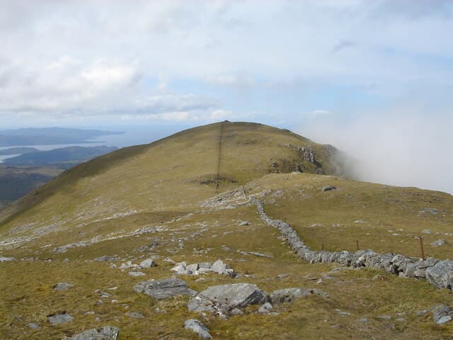
Rois-Bheinn is the highest and most westerly of the four-Corbett ridge that rises straight out of the sea between Lochailort and Loch Eilt — a hill whose 882m summit feels far higher because it stands almost directly above tidewater. The traverse east to west over Sgurr na Ba Glaise and An Stac is regarded as one of the finest mainland Corbett ridges, mixing grass, slabs and short rocky steps, with the Sound of Arisaig and the Small Isles laid out beneath. The summit cairn sits on the wreckage of an old trig point.
Quick facts
- Height
- 882.4m/ 2895ft
- Prominence
- 524 m
- Distance
- 16 km
- Ascent
- 776 m
- Time
- 5–8 hrs
- Grid ref
- NM756778
- Parking
- NM764824
- Nearest city
- Fort William· 35km
- Dogs
- Dogs on lead required near livestockDog-friendly guide ↗
Height and prominence cross-checked against the Database of British and Irish Hills (CC BY).
No GPX track yet
Walked this route? Share your track to help other walkers.
Standard route
glen track 20% · heather and bog 25% · rocky ridge 40% · summit rocks 15%
Most parties start from the lay-by near Lochailort station on the A861 and follow the path up Coire a Bhuiridh to gain the eastern end of the ridge at An Stac. From there the ridge swings west over Sgurr na Ba Glaise and a deep bealach onto the broad final pull to Rois-Bheinn. Around 16km return with 776m of net ascent though the traverse itself accumulates considerably more once the cols are factored in. Returning down the west ridge to the road via Druim Fiaclach is an option in dry conditions.
Terrain
Lower slopes through bracken and birch are damp and tick-prone in summer. The east face onto An Stac is steep and grass-slabby in the wet — many slip here on descent. The ridge itself is generally easy walking with short rocky steps but care is needed at the col between Sgurr na Ba Glaise and Rois-Bheinn where a small step drops off northwards into broken ground.
In winter
A coastal Moidart hill where snow cover is intermittent — single storms can plaster the ridge then strip it again within days. The east face below An Stac becomes a serious slope in full winter conditions and is best avoided in favour of a longer line via the western shoulder. Cornices form along the north side of the main ridge after south-westerly storms. The lochside road is rarely blocked but ice on the path approach is common.
This hill is in the Glen Coe SAIS forecast area. Check SAIS forecasts in winter (December–April).
Best time of year
Getting there
- Glasgow3h 59m
- Edinburgh4h 30m
OS maps: OS Landranger 40
Mobile signal: No signal on this remote Moidart coast hill
Current conditions
Daylight Today
- Sunrise
- 04:49
- Sunset
- 22:08
- Civil dawn
- 03:48
- Civil dusk
- 23:09
NOAA Solar Calculator · 13 July 2026
Pair with
Curated multi-hill combinations from Rois-Bheinn.
Around Rois-Bheinn on the SCOT network
Getting there, basing yourself, and what to do off the hill.
Rois-Bheinn — common questions
- How difficult is Rois-Bheinn?
- Rois-Bheinn carries a 3/5 (moderately challenging) grade on the OutdoorSCOT scale. Count on about 16km, 776m of ascent and a 5-8 hour day on the standard route. Ground conditions: Lower slopes through bracken and birch are damp and tick-prone in summer.
- How much drop does Rois-Bheinn have?
- The drop is 524m: measured from the summit of Rois-Bheinn down to the saddle joining it to higher terrain.
- Where's the parking for Rois-Bheinn?
- Park at NM764824. Double-check the grid reference on an OS map first; informal laybys here fill early in high season.
- What's the best month to climb Rois-Bheinn?
- Aim for May, June, July, August, September on Rois-Bheinn. In the remaining months treat it as a winter hill — full kit, solid navigation, and a look at the relevant SAIS avalanche forecast before you go.
- Can dogs go up Rois-Bheinn?
- Dogs are fine on a lead. The route passes livestock or ground-nesting bird habitat, so keep them close throughout.
- Will I get phone signal on Rois-Bheinn?
- No signal on this remote Moidart coast hill
- Is Rois-Bheinn safe in winter?
- A coastal Moidart hill where snow cover is intermittent — single storms can plaster the ridge then strip it again within days. The east face below An Stac becomes a serious slope in full winter conditions and is best avoided in favour of a longer line via the western shoulder. Cornices form along the north side of the main ridge after south-westerly storms. The lochside road is rarely blocked but ice on the path approach is common.
Get the OutdoorSCOT weekly
One email a week — new route, hill and bothy guides, seasonal conditions and the odd hard-won lesson. No spam, unsubscribe in one click.