Corbett · Knoydart
Meall na h-Eilde
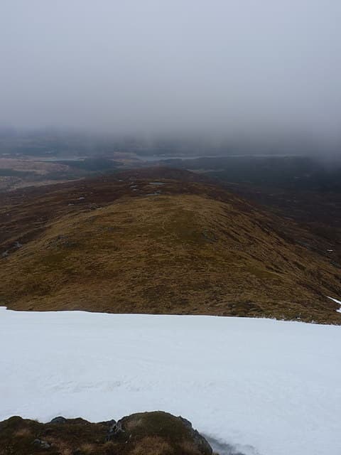
Meall na h-Eilde — "hill of the hind" — is a quiet 837m Corbett in the rough country between Loch Arkaig and Glen Garry, north-west of Achnacarry. With 450m of prominence and no near neighbours of any size, it gives a genuinely isolated feel on a hill that is rarely visited compared to its busier Munro cousins. The summit is a small rocky outcrop on a broad grassy dome with views west into Knoydart, north to the Loch Quoich Munros and south back over Loch Arkaig.
Quick facts
- Height
- 837.2m/ 2747ft
- Prominence
- 450 m
- Distance
- 15 km
- Ascent
- 737 m
- Time
- 5–7 hrs
- Grid ref
- NN185946
- Parking
- NN176888
- Nearest city
- Fort William· 22km
- Dogs
- Dogs on lead required near livestockDog-friendly guide ↗
Height and prominence cross-checked against the Database of British and Irish Hills (CC BY).
No GPX track yet
Walked this route? Share your track to help other walkers.
Standard route
forest track 30% · open heather 35% · broad ridge 25% · summit outcrop 10%
Park at the Eas Chia-aig falls car park at the east end of Loch Arkaig and walk north along the forestry track up the Allt Glas Dhoire. After about 3km, peel off the track and zig-zag pathless up rough heather onto the broad south ridge of Meall na h-Eilde. A long even pull up the ridge brings the cairn. Roughly 15km out-and-back with 737m of climbing. Often combined with neighbouring Geal Charn (Loch Arkaig Corbett) on a longer day.
Terrain
The Eas Chia-aig forestry track is firm. Off the track the ground is rough heather and bog through the lower forest line, opening to short grass on the south ridge. The summit dome is broad mossy grass with the outcrop cairn at the highest point. No exposure or technical ground anywhere. Check the forest entry signs for active felling, which may close some lower-slope tracks.
In winter
A relatively benign winter hill — gentle gradients, no avalanche slopes, and the lower approach gives some shelter through the forest. The broad summit dome is the navigation challenge in cloud or whiteout. The Loch Arkaig road is single-track and rarely gritted; in heavy snow access can be slow. Phone signal is absent throughout.
Best time of year
Getting there
- Glasgow3h 53m
- Edinburgh3h 6m
OS maps: OS Landranger 34
Mobile signal: No signal at Loch Arkaig or above; nearest reliable coverage at Spean Bridge
Current conditions
Daylight Today
- Sunrise
- 04:51
- Sunset
- 22:01
- Civil dawn
- 03:52
- Civil dusk
- 23:00
NOAA Solar Calculator · 17 July 2026
Around Meall na h-Eilde on the SCOT network
Getting there, basing yourself, and what to do off the hill.
Getting there: Roy Bridge station
Glen Roy; Grey Corries (Stob Choire Claurigh, Sgurr Choinnich Mor)
16km from the hill
tripscot.co.uk
On TripSCOTBase yourself in Fort William
Ben Nevis base, West Highland Line, gateway to Lochaber
22km from the hill
tripscot.co.uk
On TasteSCOTAfter the hill: Ben Nevis Distillery
Fort William — Lochaber distillery at the foot of the Ben; long-aged Japanese-owned classics
20km from the hill
tastescot.co.uk
Meall na h-Eilde — common questions
- What difficulty is Meall na h-Eilde?
- On the OutdoorSCOT scale, Meall na h-Eilde comes in at 3/5 — moderately challenging. Expect roughly 15km and 737m of ascent on the usual route — 5-7 hours for most parties. Underfoot: The Eas Chia-aig forestry track is firm.
- What is Meall na h-Eilde's prominence?
- 450m of prominence. That's the vertical drop from the summit to the col that links Meall na h-Eilde to the next higher ground.
- Where do I park for Meall na h-Eilde?
- Most walkers start from NN176888. Verify the grid reference on an OS map before you set off — space is tight on busy summer weekends.
- When is the best time to climb Meall na h-Eilde?
- April, May, June, July, August, September, October give the most reliable conditions on Meall na h-Eilde. Beyond that window the high ground turns wintry: carry full mountain kit, be confident navigating, and check the SAIS avalanche forecast for the area.
- Is Meall na h-Eilde dog-friendly?
- Yes, but dogs must be kept on a lead — there is livestock or ground-nesting bird interest on the route.
- Is there mobile signal on Meall na h-Eilde?
- No signal at Loch Arkaig or above; nearest reliable coverage at Spean Bridge
- Is Meall na h-Eilde safe in winter?
- A relatively benign winter hill — gentle gradients, no avalanche slopes, and the lower approach gives some shelter through the forest. The broad summit dome is the navigation challenge in cloud or whiteout. The Loch Arkaig road is single-track and rarely gritted; in heavy snow access can be slow. Phone signal is absent throughout.
Get the OutdoorSCOT weekly
One email a week — new route, hill and bothy guides, seasonal conditions and the odd hard-won lesson. No spam, unsubscribe in one click.