Corbett · Glen Garry
Meall Dubh
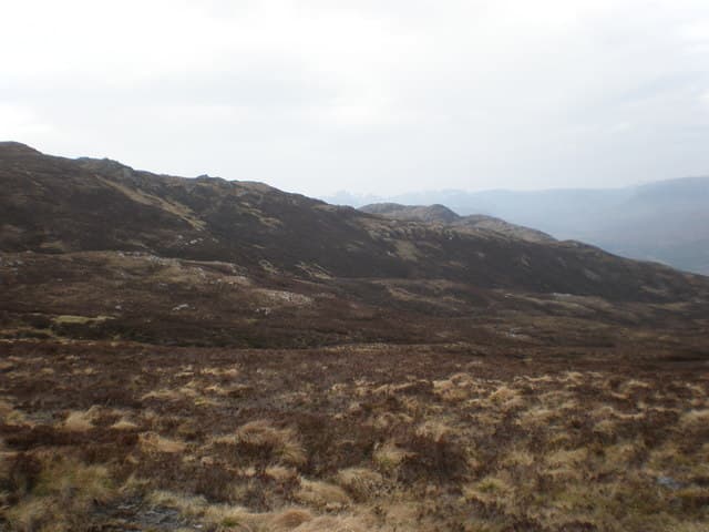
Meall Dubh — "the dark hill" — is the dome-shaped 789m Corbett above Loch Loyne, in the rolling country between Glen Garry and Glen Moriston. A 544m prominence sets it well clear of any near neighbour, and the broad summit area carries a small rocky cairn with views west toward the Cluanie Munros, south to the Loch Quoich hills and east into the Great Glen. The hill's peat-and-heather flanks earn its name; the upper ground is often gloomy even on bright days.
Gaelic: “rounded hill, black” · Pronunciation: myowl doo
Quick facts
- Height
- 789m/ 2589ft
- Prominence
- 544 m
- Distance
- 14 km
- Ascent
- 647 m
- Time
- 4–7 hrs
- Grid ref
- NH245078
- Parking
- NH213080
- Nearest city
- Fort William· 37km
- Dogs
- Dogs on lead required near livestockDog-friendly guide ↗
Height and prominence cross-checked against the Database of British and Irish Hills (CC BY).
No GPX track yet
Walked this route? Share your track to help other walkers.
Standard route
military road 25% · wet heather 40% · broad ridge 25% · summit cairn 10%
Park at the lay-by on the A87 at the west end of Loch Cluanie or near Loch Loyne and follow the old military road south across the moor toward Tomdoun. After roughly 2km, leave the track and climb pathless heather slopes east onto the broad north ridge of Meall Dubh. Steady gradient on the ridge leads to the summit. Total roughly 14km and 647m of climbing. Frequently combined with neighbouring Corbett Sgurr nan Conbhairean for a long day, though that adds a Munro.
Terrain
The old military road is firm. Off the track the lower hill is wet peat and tussock with no path — slow walking. The broad ridge is short heather and crowberry with the summit cairn easy to find. No exposure or scrambling. The boggy approach is the main slow-down factor.
In winter
A typical winter Corbett of the central Highlands fringe — gentle gradients but exposed to whatever wind is blowing through Glen Moriston. No avalanche concerns on the broad slopes. The A87 is gritted but the lay-bys ice over. Phone signal is absent across much of the route.
Best time of year
Getting there
- Glasgow3h 7m
- Edinburgh3h 13m
OS maps: OS Landranger 34
Mobile signal: Intermittent at Cluanie / Loch Loyne; nothing on the summit
Current conditions
Daylight Today
- Sunrise
- 04:43
- Sunset
- 22:07
- Civil dawn
- 03:42
- Civil dusk
- 23:09
NOAA Solar Calculator · 13 July 2026
Pair with
Curated multi-hill combinations from Meall Dubh.
Around Meall Dubh on the SCOT network
Getting there, basing yourself, and what to do off the hill.
Meall Dubh — common questions
- Is Meall Dubh a hard climb?
- Meall Dubh is rated 2/5 (moderate) on the OutdoorSCOT scale. The standard route covers about 14km with 647m of ascent and takes most walkers 4-7 hours. Underfoot: The old military road is firm.
- What is Meall Dubh's prominence?
- 544m of prominence. That's the vertical drop from the summit to the col that links Meall Dubh to the next higher ground.
- Where do I park for Meall Dubh?
- Most walkers start from NH213080. Verify the grid reference on an OS map before you set off — space is tight on busy summer weekends.
- When is the best time to climb Meall Dubh?
- April, May, June, July, August, September, October give the most reliable conditions on Meall Dubh. Beyond that window the high ground turns wintry: carry full mountain kit, be confident navigating, and check the SAIS avalanche forecast for the area.
- Is Meall Dubh dog-friendly?
- Yes, but dogs must be kept on a lead — there is livestock or ground-nesting bird interest on the route.
- Is there mobile signal on Meall Dubh?
- Intermittent at Cluanie / Loch Loyne; nothing on the summit
- Is Meall Dubh safe in winter?
- A typical winter Corbett of the central Highlands fringe — gentle gradients but exposed to whatever wind is blowing through Glen Moriston. No avalanche concerns on the broad slopes. The A87 is gritted but the lay-bys ice over. Phone signal is absent across much of the route.
Get the OutdoorSCOT weekly
One email a week — new route, hill and bothy guides, seasonal conditions and the odd hard-won lesson. No spam, unsubscribe in one click.