Graham · Central Highlands
Carn Mhic an Toisich
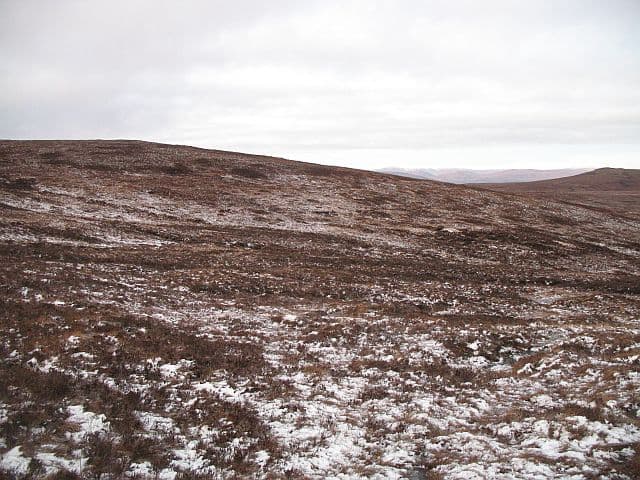
Carn Mhic an Toisich (678m) — the cairn of Mackintosh's son — rises above the south side of Glen Moriston in NH31 near Invermoriston. It is a sprawling moorland hill on the rolling watershed between the Great Glen and Strathfarrar, with a flat summit cairn looking south to the Affric Munros and north over Loch Ness.
Gaelic: “cairn-topped hill, son of, the” · Pronunciation: karn mhic an toisich
Quick facts
- Height
- 678.2m/ 2225ft
- Prominence
- 176 m
- Distance
- 13 km
- Ascent
- 556 m
- Time
- 4–6 hrs
- Grid ref
- NH310185
- Parking
- NH280183
- Nearest city
- Inverness· 44km
- Dogs
- Dogs on lead required near livestockDog-friendly guide ↗
Height and prominence cross-checked against the Database of British and Irish Hills (CC BY).
No GPX track yet
Walked this route? Share your track to help other walkers.
Standard route
heather moorland 65% · grass slopes 25% · rocky summit 10%
Start from the A887 layby east of Bhlaraidh and follow the hydro access track south up the Allt Saigh. Branch off west onto open hill near 400m and climb the heathery shoulder, picking a line between peat hags onto the gentle summit dome. The cairn sits on the highest of several similar bumps so a careful compass approach is required in cloud.
Terrain
Hydro track on the lower flank, then thick heather and recurring peat hags on the broad moor. The summit area has several near-equal bumps and a series of erosion scars that confuse the eye. Pathless throughout above the track.
In winter
Glen Moriston sees moderate snow cover and the south side traps drifts well into spring. The featureless summit plateau is a serious whiteout proposition with no edges to navigate to. Wind chill from southerlies funnelled up the Great Glen is the discomfort to expect.
This hill is in the Creag Meagaidh SAIS forecast area. Check SAIS forecasts in winter (December–April).
Best time of year
Getting there
- Glasgow3h 0m
- Edinburgh3h 19m
OS maps: OS Landranger 34
Mobile signal: Poor. Remote Loch Monar area; limited coverage.
Current conditions
Daylight Today
- Sunrise
- 04:42
- Sunset
- 22:08
- Civil dawn
- 03:40
- Civil dusk
- 23:10
NOAA Solar Calculator · 13 July 2026
Around Carn Mhic an Toisich on the SCOT network
Getting there, basing yourself, and what to do off the hill.
Carn Mhic an Toisich — common questions
- What difficulty is Carn Mhic an Toisich?
- On the OutdoorSCOT scale, Carn Mhic an Toisich comes in at 4/5 — challenging. Expect roughly 13km and 556m of ascent on the usual route — 4-6 hours for most parties. Underfoot: Hydro track on the lower flank, then thick heather and recurring peat hags on the broad moor.
- What is Carn Mhic an Toisich's prominence?
- 176m of prominence. That's the vertical drop from the summit to the col that links Carn Mhic an Toisich to the next higher ground.
- Where do I park for Carn Mhic an Toisich?
- Most walkers start from NH280183. Verify the grid reference on an OS map before you set off — space is tight on busy summer weekends.
- When is the best time to climb Carn Mhic an Toisich?
- March, April, May, June, July, August, September, October, November give the most reliable conditions on Carn Mhic an Toisich. Beyond that window the high ground turns wintry: carry full mountain kit, be confident navigating, and check the SAIS avalanche forecast for the area.
- Is Carn Mhic an Toisich dog-friendly?
- Yes, but dogs must be kept on a lead — there is livestock or ground-nesting bird interest on the route.
- Is there mobile signal on Carn Mhic an Toisich?
- Poor. Remote Loch Monar area; limited coverage.
- Is Carn Mhic an Toisich safe in winter?
- Glen Moriston sees moderate snow cover and the south side traps drifts well into spring. The featureless summit plateau is a serious whiteout proposition with no edges to navigate to. Wind chill from southerlies funnelled up the Great Glen is the discomfort to expect.
Get the OutdoorSCOT weekly
One email a week — new route, hill and bothy guides, seasonal conditions and the odd hard-won lesson. No spam, unsubscribe in one click.