Graham · Kintail
Burach
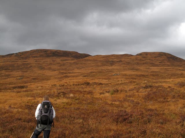
Burach (607m) is a quiet rolling Graham set in the moorland country between Glen Urquhart and Glen Affric, in the NH38 square south-west of Drumnadrochit. Its long flat back overlooks the RSPB Corrimony reserve and the chain of lochans on Carn na Saobhaidhe, with the Affric Munros lifting the horizon to the south. The summit cairn perches on a rocky boss above peat hags, and on a clear day the eye can follow the Great Glen all the way to Ben Wyvis.
Quick facts
- Height
- 607m/ 1991ft
- Prominence
- 236 m
- Distance
- 12 km
- Ascent
- 455 m
- Time
- 3–5 hrs
- Grid ref
- NH382141
- Parking
- NH330103
- Nearest city
- Inverness· 42km
- Dogs
- Dogs on lead required near livestockDog-friendly guide ↗
Height and prominence cross-checked against the Database of British and Irish Hills (CC BY).
No GPX track yet
Walked this route? Share your track to help other walkers.
Standard route
heather and bog 60% · rocky slopes 25% · grassy hollows 15%
The most efficient line starts from the forestry track near Corrimony at NH330103, following the bulldozed track east before striking south across open moor onto the broad north ridge. Around 12km return with 455m of ascent — a half-day outing once the worst of the bog is behind you. The summit ridge is broad and grassy, with the high point marked by a small cairn on a low rocky knoll near the trig pillar a short distance west.
Terrain
Forestry tracks give a dry start but the open hillside above is heavy with peat hags, deer-grass and patches of cotton grass. Burns swell quickly after rain; the small feeder of the Allt Sigh can be awkward to cross in spate. Once on the broad summit plateau the going firms up onto short turf and gravel between low outcrops of schist.
In winter
Burach catches comparatively little snow but the peat hags freeze into slippery troughs that hide standing water beneath. The plateau is featureless under a covering of fresh snow and the trig pillar can be missed by twenty metres in a flat light. The forestry track in is usually clear and makes a sensible bail-out line back to the road.
Best time of year
Getting there
- Glasgow3h 53m
- Edinburgh3h 10m
OS maps: OS Landranger 34
Mobile signal: Poor. Remote Knoydart; no reliable coverage on any network.
Current conditions
Daylight Today
- Sunrise
- 04:48
- Sunset
- 22:01
- Civil dawn
- 03:49
- Civil dusk
- 23:01
NOAA Solar Calculator · 17 July 2026
On a long-distance route
Burach sits within 5km of these named long-distance walks — useful for trail-pack rest days or section extensions.
Around Burach on the SCOT network
Getting there, basing yourself, and what to do off the hill.
Burach — common questions
- Is Burach a hard climb?
- Burach is rated 3/5 (moderately challenging) on the OutdoorSCOT scale. The standard route covers about 12km with 455m of ascent and takes most walkers 3-5 hours. Underfoot: Forestry tracks give a dry start but the open hillside above is heavy with peat hags, deer-grass and patches of cotton grass.
- What is Burach's prominence?
- 236m of prominence. That's the vertical drop from the summit to the col that links Burach to the next higher ground.
- Where do I park for Burach?
- Most walkers start from NH330103. Verify the grid reference on an OS map before you set off — space is tight on busy summer weekends.
- When is the best time to climb Burach?
- March, April, May, June, July, August, September, October, November give the most reliable conditions on Burach. Beyond that window the high ground turns wintry: carry full mountain kit, be confident navigating, and check the SAIS avalanche forecast for the area.
- Is Burach dog-friendly?
- Yes, but dogs must be kept on a lead — there is livestock or ground-nesting bird interest on the route.
- Is there mobile signal on Burach?
- Poor. Remote Knoydart; no reliable coverage on any network.
- Is Burach safe in winter?
- Burach catches comparatively little snow but the peat hags freeze into slippery troughs that hide standing water beneath. The plateau is featureless under a covering of fresh snow and the trig pillar can be missed by twenty metres in a flat light. The forestry track in is usually clear and makes a sensible bail-out line back to the road.
Get the OutdoorSCOT weekly
One email a week — new route, hill and bothy guides, seasonal conditions and the odd hard-won lesson. No spam, unsubscribe in one click.