Corbett · Central Highlands
Carn a' Chuilinn
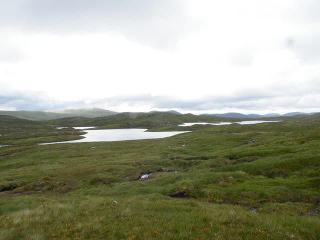
Carn a' Chuilinn — "the cairn of the holly" — is a quiet 817m Corbett in the Monadhliath, south-east of Fort Augustus in the upper Glen Tarff country. The hill sits on the watershed between Loch Ness and the upper Spey and is most often climbed in conjunction with neighbouring Geal-charn Mor or Meall na h-Aisre. The summit is a small rocky cairn on a broad heather plateau with sweeping outlooks west across the Great Glen toward the Loch Lochy peaks and north over Loch Ness to the Inverness coast.
Quick facts
- Height
- 817m/ 2680ft
- Prominence
- 178 m
- Distance
- 15 km
- Ascent
- 719 m
- Time
- 4–7 hrs
- Grid ref
- NH416033
- Parking
- NH415086
- Nearest city
- Fort William· 43km
- Dogs
- Dogs on lead required near livestockDog-friendly guide ↗
Height and prominence cross-checked against the Database of British and Irish Hills (CC BY).
No GPX track yet
Walked this route? Share your track to help other walkers.
Standard route
estate track 40% · rough heather 35% · broad plateau 20% · rock cairn 5%
Start from the public road end at Glen Doe estate gate east of Fort Augustus and follow the hill track south up the Allt Doe and into upper Glen Tarff. After around 5km, leave the track and zig-zag pathless up heather slopes east to gain the broad south ridge of Carn a' Chuilinn. A gradual climb up the ridge brings the cairn. Around 15km out-and-back with 719m of climbing. Most parties tackle it as a single-summit day given the broad pathless country around it.
Terrain
The Glen Doe estate track is firm gravel — bike-friendly for the long approach. Beyond the gravel the hillside is rough heather and peat with no path; the climb is gentle but plodding. The summit plateau is short heather and small rock outcrops with the cairn unmistakable in clear weather. No exposure or technical ground anywhere on the hill.
In winter
A typical Monadhliath winter hill — gentle gradients, no avalanche slopes, and reliable drifting on the broad plateau. The Glen Doe estate roads are not gritted; access can be difficult after heavy snow. Phone signal is absent. Daylight is short but the gentle terrain makes for a manageable day in stable conditions.
This hill is in the Creag Meagaidh SAIS forecast area. Check SAIS forecasts in winter (December–April).
Best time of year
Getting there
- Glasgow3h 57m
- Edinburgh3h 58m
OS maps: OS Landranger 34
Mobile signal: Intermittent at Fort Augustus; nothing on the hill
Current conditions
Daylight Today
- Sunrise
- 04:42
- Sunset
- 22:06
- Civil dawn
- 03:41
- Civil dusk
- 23:07
NOAA Solar Calculator · 13 July 2026
Around Carn a' Chuilinn on the SCOT network
Getting there, basing yourself, and what to do off the hill.
Getting there: Roy Bridge station
Glen Roy; Grey Corries (Stob Choire Claurigh, Sgurr Choinnich Mor)
26km from the hill
tripscot.co.uk
On TripSCOTBase yourself in Fort William
Ben Nevis base, West Highland Line, gateway to Lochaber
43km from the hill
tripscot.co.uk
On TasteSCOTAfter the hill: Dalwhinnie
Dalwhinnie — Scotland's highest distillery on the Drumochter pass
28km from the hill
tastescot.co.uk
Carn a' Chuilinn — common questions
- Is Carn a' Chuilinn a hard climb?
- Carn a' Chuilinn is rated 3/5 (moderately challenging) on the OutdoorSCOT scale. The standard route covers about 15km with 719m of ascent and takes most walkers 4-7 hours. Underfoot: The Glen Doe estate track is firm gravel — bike-friendly for the long approach.
- What is Carn a' Chuilinn's prominence?
- 178m of prominence. That's the vertical drop from the summit to the col that links Carn a' Chuilinn to the next higher ground.
- Where do I park for Carn a' Chuilinn?
- Most walkers start from NH415086. Verify the grid reference on an OS map before you set off — space is tight on busy summer weekends.
- When is the best time to climb Carn a' Chuilinn?
- April, May, June, July, August, September, October give the most reliable conditions on Carn a' Chuilinn. Beyond that window the high ground turns wintry: carry full mountain kit, be confident navigating, and check the SAIS avalanche forecast for the area.
- Is Carn a' Chuilinn dog-friendly?
- Yes, but dogs must be kept on a lead — there is livestock or ground-nesting bird interest on the route.
- Is there mobile signal on Carn a' Chuilinn?
- Intermittent at Fort Augustus; nothing on the hill
- Is Carn a' Chuilinn safe in winter?
- A typical Monadhliath winter hill — gentle gradients, no avalanche slopes, and reliable drifting on the broad plateau. The Glen Doe estate roads are not gritted; access can be difficult after heavy snow. Phone signal is absent. Daylight is short but the gentle terrain makes for a manageable day in stable conditions.
Get the OutdoorSCOT weekly
One email a week — new route, hill and bothy guides, seasonal conditions and the odd hard-won lesson. No spam, unsubscribe in one click.