Corbett · Central Highlands
Carn Dearg
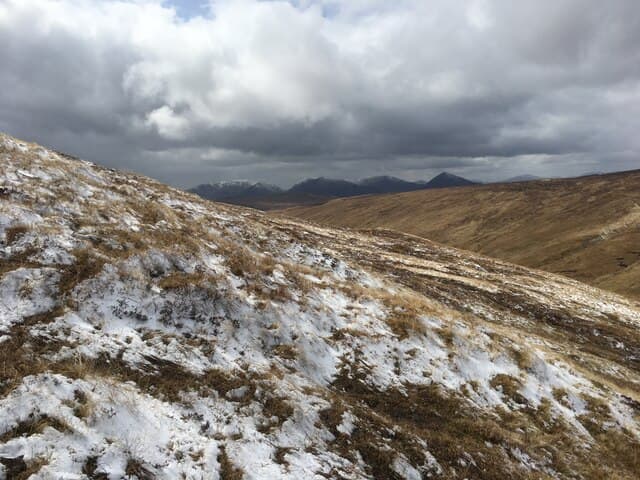
This Carn Dearg — "red cairn", one of several across Scotland — is the 768m Corbett in the rough country between Glen Roy and the head of Loch Lochy, north of Spean Bridge. The hill sits in deer-forest country with a small rocky cairn on a wide heather summit; the red-tinged Dalradian schist of the upper slopes gives the hill its name. The view east takes in the upper Spean and the Creag Meagaidh ridge, west across the Great Glen to the Loch Lochy peaks.
Gaelic: “cairn-topped hill, red” · Pronunciation: karn jerr-ak
Quick facts
- Height
- 768m/ 2520ft
- Prominence
- 196 m
- Distance
- 14 km
- Ascent
- 630 m
- Time
- 4–7 hrs
- Grid ref
- NN357948
- Parking
- NN335912
- Nearest city
- Fort William· 33km
- Dogs
- Dogs on lead required near livestockDog-friendly guide ↗
Height and prominence cross-checked against the Database of British and Irish Hills (CC BY).
No GPX track yet
Walked this route? Share your track to help other walkers.
Standard route
estate track 30% · rough heather 35% · broad ridge 25% · summit cairn 10%
Start from the road end at Brae Roy Lodge in upper Glen Roy and follow the public estate track north-west for around 4km, then climb pathless heather slopes north onto the broad south ridge of Carn Dearg. The ridge gives a gradual pull to the summit. Around 14km return with 630m of ascent. The famous Parallel Roads of Glen Roy give striking foreground views on the approach.
Terrain
The Glen Roy estate track is firm gravel. Off the track the hillside is rough heather and tussock; the climb to the ridge is pathless and slow. The broad summit ridge is short heather with the cairn at the highest of several similar bumps. No exposure or scrambling. Stalking activity in season.
In winter
A typical central Highlands winter Corbett — gentle gradients and no avalanche concerns but the open ridge takes full easterly weather. The Glen Roy road can drift up; access can be slow after heavy snow. The Parallel Roads are particularly atmospheric under a snow dusting.
This hill is in the Creag Meagaidh SAIS forecast area. Check SAIS forecasts in winter (December–April).
Best time of year
Getting there
- Glasgow3h 48m
- Edinburgh3h 54m
OS maps: OS Landranger 34
Mobile signal: No bars in upper Glen Roy; intermittent at Brae Roy
Current conditions
Daylight Today
- Sunrise
- 04:43
- Sunset
- 22:06
- Civil dawn
- 03:42
- Civil dusk
- 23:07
NOAA Solar Calculator · 13 July 2026
Pair with
Curated multi-hill combinations from Carn Dearg.
Around Carn Dearg on the SCOT network
Getting there, basing yourself, and what to do off the hill.
Getting there: Roy Bridge station
Glen Roy; Grey Corries (Stob Choire Claurigh, Sgurr Choinnich Mor)
16km from the hill
tripscot.co.uk
On TripSCOTBase yourself in Fort William
Ben Nevis base, West Highland Line, gateway to Lochaber
33km from the hill
tripscot.co.uk
On TasteSCOTAfter the hill: Dalwhinnie
Dalwhinnie — Scotland's highest distillery on the Drumochter pass
29km from the hill
tastescot.co.uk
Carn Dearg — common questions
- How hard is Carn Dearg?
- We grade Carn Dearg at 2/5, which puts it in moderate territory. The usual route is around 14km with 630m of climbing; allow 4-7 hours. Ground conditions: The Glen Roy estate track is firm gravel.
- How much drop does Carn Dearg have?
- The drop is 196m: measured from the summit of Carn Dearg down to the saddle joining it to higher terrain.
- Where's the parking for Carn Dearg?
- Park at NN335912. Double-check the grid reference on an OS map first; informal laybys here fill early in high season.
- What's the best month to climb Carn Dearg?
- Aim for April, May, June, July, August, September, October on Carn Dearg. In the remaining months treat it as a winter hill — full kit, solid navigation, and a look at the relevant SAIS avalanche forecast before you go.
- Can dogs go up Carn Dearg?
- Dogs are fine on a lead. The route passes livestock or ground-nesting bird habitat, so keep them close throughout.
- Will I get phone signal on Carn Dearg?
- No bars in upper Glen Roy; intermittent at Brae Roy
- Is Carn Dearg safe in winter?
- A typical central Highlands winter Corbett — gentle gradients and no avalanche concerns but the open ridge takes full easterly weather. The Glen Roy road can drift up; access can be slow after heavy snow. The Parallel Roads are particularly atmospheric under a snow dusting.
Get the OutdoorSCOT weekly
One email a week — new route, hill and bothy guides, seasonal conditions and the odd hard-won lesson. No spam, unsubscribe in one click.