Corbett · Central Highlands
Carn Dearg
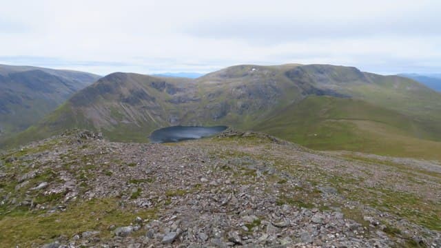
Càrn Dearg is the 834m Corbett rising west of Loch Ossian, sharing the Corrour station catchment with Leum Uilleim and the lower Munros to the south. Train access from Glasgow to Corrour makes the hill among the genuinely car-free Corbetts, although the walk-in from the station is long and runs through some of the wettest country in Britain. The summit is reached over rolling grass-and-heather flanks; the views look east across Loch Ossian to Ben Alder and west to the Mamores.
Gaelic: “cairn-topped hill, red” · Pronunciation: karn jerr-ak
Quick facts
- Height
- 834.4m/ 2738ft
- Prominence
- 251 m
- Distance
- 18 km
- Ascent
- 600 m
- Time
- 4–6 hrs
- Grid ref
- NN345887
- Nearest city
- Fort William· 28km
- Dogs
- Dogs on lead required near livestockDog-friendly guide ↗
Height and prominence cross-checked against the Database of British and Irish Hills (CC BY).
No GPX track yet
Walked this route? Share your track to help other walkers.
Standard route
boat access 15% · rough moorland 45% · heather hillside 30% · summit area 10%
From Corrour railway station, follow the path south along Loch Ossian for around 4km. Where the path branches near Corrour Lodge, head south-west onto the open hillside and climb the broad east ridge of Càrn Dearg. A consistent climb up moor and grass leads to the small summit cairn. Return reverses the line to the station — pace it carefully to catch the train back. Allow 6–7 hours from station to station.
Terrain
Estate path along Loch Ossian for the first part — easy walking through one of Scotland's largest privately-owned native pine plantings. Above the path the ground is heather and bog with no real trail. The high point opens onto wide grass with an unremarkable cairn. Drier on the upper hill than the loch-side approach suggests.
In winter
Corrour station stays open year-round; the West Highland Line train is reliable in winter, making this a useful access option when roads close. Snow lies long on the broad summit and Loch Ossian itself sometimes freezes. The path runs through Forestry land that holds drift; navigation in cloud needs care above the loch.
This hill is in the Creag Meagaidh SAIS forecast area. Check SAIS forecasts in winter (December–April).
Best time of year
Getting there
- Glasgow3h 40m
- Edinburgh3h 7m
OS maps: OS Landranger 34
Mobile signal: No usable signal at Corrour station or on the hill — central Rannoch Moor is one of the largest mobile blackspots in Britain
Current conditions
Daylight Today
- Sunrise
- 04:44
- Sunset
- 22:05
- Civil dawn
- 03:43
- Civil dusk
- 23:06
NOAA Solar Calculator · 13 July 2026
Pair with
Curated multi-hill combinations from Carn Dearg.
Around Carn Dearg on the SCOT network
Getting there, basing yourself, and what to do off the hill.
Getting there: Roy Bridge station
Glen Roy; Grey Corries (Stob Choire Claurigh, Sgurr Choinnich Mor)
10km from the hill
tripscot.co.uk
On TripSCOTBase yourself in Fort William
Ben Nevis base, West Highland Line, gateway to Lochaber
28km from the hill
tripscot.co.uk
On TasteSCOTAfter the hill: Ben Nevis Distillery
Fort William — Lochaber distillery at the foot of the Ben; long-aged Japanese-owned classics
26km from the hill
tastescot.co.uk
Carn Dearg — common questions
- Is Carn Dearg a hard climb?
- Carn Dearg is rated 2/5 (moderate) on the OutdoorSCOT scale. The standard route covers about 18km with 600m of ascent and takes most walkers 4-6 hours. Ground conditions: Estate path along Loch Ossian for the first part — easy walking through one of Scotland's largest privately-owned native pine plantings.
- How much drop does Carn Dearg have?
- The drop is 251m: measured from the summit of Carn Dearg down to the saddle joining it to higher terrain.
- What's the best month to climb Carn Dearg?
- Aim for April, May, June, July, August, September, October on Carn Dearg. In the remaining months treat it as a winter hill — full kit, solid navigation, and a look at the relevant SAIS avalanche forecast before you go.
- Can dogs go up Carn Dearg?
- Dogs are fine on a lead. The route passes livestock or ground-nesting bird habitat, so keep them close throughout.
- Will I get phone signal on Carn Dearg?
- No usable signal at Corrour station or on the hill — central Rannoch Moor is one of the largest mobile blackspots in Britain
- Is Carn Dearg safe in winter?
- Corrour station stays open year-round; the West Highland Line train is reliable in winter, making this a useful access option when roads close. Snow lies long on the broad summit and Loch Ossian itself sometimes freezes. The path runs through Forestry land that holds drift; navigation in cloud needs care above the loch.
Get the OutdoorSCOT weekly
One email a week — new route, hill and bothy guides, seasonal conditions and the odd hard-won lesson. No spam, unsubscribe in one click.