Munro · Central Highlands
Beinn a' Chaorainn
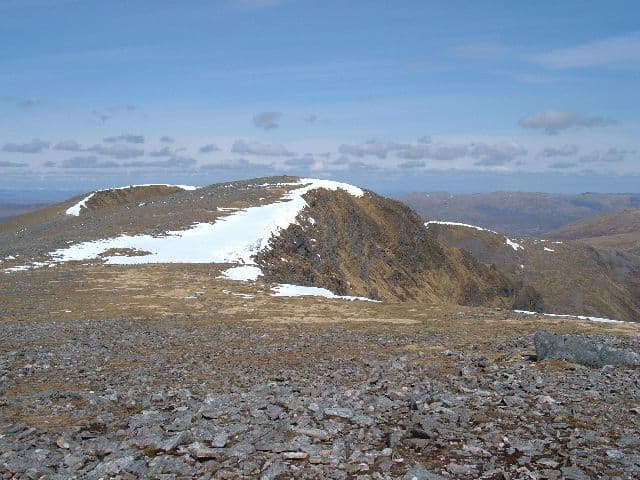
Beinn a' Chaorainn (1049m) — the Glen Spean hill, not to be confused with its Cairngorm namesake — is a long three-topped Munro east of Spean Bridge. It is invariably paired with Beinn Teallach to the north-west, the easternmost of all Munros to be promoted (only just over 914m). The hill has a distinctive trio of summits running along a north-south ridge, with the central top the official high point. The east face holds an impressive series of cliffs and gullies above Coire na h-Uamha.
Quick facts
- Height
- 1049.1m/ 3442ft
- Prominence
- 227 m
- Distance
- 18 km
- Ascent
- 923 m
- Time
- 6–9 hrs
- Grid ref
- NN386850
- Parking
- NN377813
- Nearest city
- Fort William· 30km
- Dogs
- Dogs on lead required near livestockDog-friendly guide ↗
Height and prominence cross-checked against the Database of British and Irish Hills (CC BY).
No GPX track yet
Walked this route? Share your track to help other walkers.
Standard route
Forestry track / path 35% · Open hillside 40% · Summit ridge with three tops 25%
Park at the small lay-by at Roughburn at the eastern end of Loch Laggan, just below the dam. Follow the forestry track south through young plantation, then break onto open hillside and climb the broad north ridge of Beinn a' Chaorainn. Traverse all three tops (north, central — the Munro — and south) and return. Most parties continue west across the deep bealach to Beinn Teallach. Around 17km with 1200m of ascent for the pair; Chaorainn alone is 12km with 850m up.
Terrain
The Roughburn forest track is firm but the break onto open hill is wet boggy ground. The north ridge is a broad easy walk on heather and short grass. The summit area is three tops on a narrow rocky crest with one cornice-prone section between north and central tops. The east face cliffs come close to the path — a serious mist hazard. The descent to the Beinn Teallach bealach is steep wet grass.
In winter
A serious Lochaber winter Munro. The east cliffs of Beinn a' Chaorainn have a long incident history — walkers have stepped through cornices onto the cliff edge with fatal results. Cornicing on the east side of the summit ridge is consistent through the season. SAIS Lochaber applies. The Roughburn car park sits beside the A86 which stays gritted. Take great care navigating the summit ridge in poor visibility.
This hill is in the Creag Meagaidh SAIS forecast area. Check SAIS forecasts in winter (December–April).
Best time of year
Getting there
- Glasgow3h 35m
- Edinburgh3h 0m
OS maps: OS Landranger 34, OS Landranger 41
Mobile signal: No coverage above 700m in the Ardverikie Forest. Laggan or Tulloch has occasional 4G. Download mapping before setting off.
Current conditions
Daylight Today
- Sunrise
- 05:00
- Sunset
- 21:50
- Civil dawn
- 04:05
- Civil dusk
- 22:45
NOAA Solar Calculator · 23 July 2026
Pair with
Curated multi-hill combinations from Beinn a' Chaorainn.
On a long-distance route
Beinn a' Chaorainn sits within 5km of these named long-distance walks — useful for trail-pack rest days or section extensions.
Around Beinn a' Chaorainn on the SCOT network
Getting there, basing yourself, and what to do off the hill.
Getting there: Tulloch station
Loch Treig; Beinn na Lap; Stob Coire Easain / Stob a Choire Mheadhoin approach
8km from the hill
tripscot.co.uk
On TripSCOTBase yourself in Fort William
Ben Nevis base, West Highland Line, gateway to Lochaber
30km from the hill
tripscot.co.uk
On TasteSCOTAfter the hill: Dalwhinnie
Dalwhinnie — Scotland's highest distillery on the Drumochter pass
25km from the hill
tastescot.co.uk
Beinn a' Chaorainn — common questions
- Is Beinn a' Chaorainn a hard climb?
- Beinn a' Chaorainn is rated 4/5 (challenging) on the OutdoorSCOT scale. The standard route covers about 18km with 923m of ascent and takes most walkers 6-9 hours. Terrain: The Roughburn forest track is firm but the break onto open hill is wet boggy ground.
- How prominent is Beinn a' Chaorainn?
- Beinn a' Chaorainn has 227m of topographic prominence — the height of its summit above the highest col connecting it to higher ground.
- Where should I park to climb Beinn a' Chaorainn?
- Standard parking is at NN377813. Check the parking grid reference on an OS map before travel; informal laybys can fill on summer weekends.
- When should I climb Beinn a' Chaorainn?
- The standard good-weather months for Beinn a' Chaorainn are May, June, July, August, September, October. Outside those months, expect winter conditions on the high ground — full mountain kit, navigation skills, and a check of the SAIS avalanche forecast for the relevant region.
- Can I bring my dog up Beinn a' Chaorainn?
- On a lead only — the route crosses ground with livestock or nesting-bird interest.
- What's mobile reception like on Beinn a' Chaorainn?
- No coverage above 700m in the Ardverikie Forest. Laggan or Tulloch has occasional 4G. Download mapping before setting off.
- Is Beinn a' Chaorainn safe in winter?
- A serious Lochaber winter Munro. The east cliffs of Beinn a' Chaorainn have a long incident history — walkers have stepped through cornices onto the cliff edge with fatal results. Cornicing on the east side of the summit ridge is consistent through the season. SAIS Lochaber applies. The Roughburn car park sits beside the A86 which stays gritted. Take great care navigating the summit ridge in poor visibility.
Get the OutdoorSCOT weekly
One email a week — new route, hill and bothy guides, seasonal conditions and the odd hard-won lesson. No spam, unsubscribe in one click.