Munro · Central Highlands
Stob Poite Coire Ardair
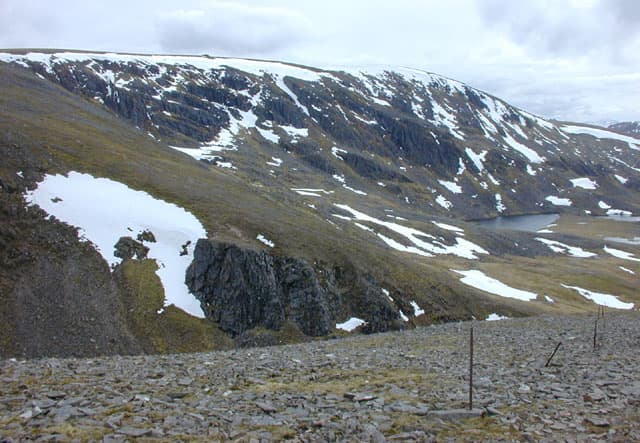
Stob Poite Coire Ardair (1052m) is the western Munro of the Creag Meagaidh group above Loch Laggan — a long whaleback summit forming the northern rim of the spectacular Coire Ardair cliffs. The corrie itself is one of the great winter climbing venues in Scotland: a 400m headwall of mica-schist with classic ice routes including "The Pumpkin" and "Smith's Gully". The Munro is almost always tackled together with Creag Meagaidh and the third summit Càrn Liath in a classic horseshoe round.
Gaelic: “pointed peak, pot, corrie” · Pronunciation: stob poite kor-a ardair
Quick facts
- Height
- 1052.5m/ 3453ft
- Prominence
- 107 m
- Distance
- ~18 km
- Ascent
- ~926 m
- Time
- 6–9 hrs
- Grid ref
- NN428888
- Parking
- NN483872
- Nearest city
- Fort William· 35km
- Dogs
- Dogs on lead required near livestockDog-friendly guide ↗
Height and prominence cross-checked against the Database of British and Irish Hills (CC BY).
No GPX track yet
Walked this route? Share your track to help other walkers.
Standard route
Aberarder path 35% · Open hillside 35% · Summit ridge 30%
Begin at the Aberarder NNR car park beside the A86 above Loch Laggan. Follow the stalkers' path north-east up the glen to Lochan a' Choire — the famous "post box" lochan beneath the Coire Ardair cliffs. Branch left up the steep grass to The Window, the dramatic notch in the ridge between Stob Poite and Creag Meagaidh, then turn west along the broad ridge to Stob Poite Coire Ardair. The full horseshoe continues east over Creag Meagaidh and back to Carn Liath. Around 21km with 1300m of ascent for the three Munros.
Terrain
The Aberarder path is well-graded and surfaced for the lower section; above the woods it is rough heathery hillside but follows a clear line. The climb to The Window is steep grass and broken rock — straightforward in summer but a notorious avalanche slope under snow. The summit ridge of Stob Poite is broad and easy with several false tops along its length. The descent off Càrn Liath at the end of the round is steep grass back to the road.
In winter
The premier Scottish winter mountaineering venue. The Window slope is the most notorious avalanche site in the Creag Meagaidh area — a serious incident in 1985 led directly to the founding of the SAIS service. Coire Ardair cliffs hold Grade III–VI ice routes. The plateau above can be a serious whiteout zone. SAIS Creag Meagaidh applies and is one of the most-consulted forecasts. Full winter mountaineering kit essential.
Kit for this: the winter Munro kit list · which boots take crampons
This hill is in the Creag Meagaidh SAIS forecast area. Check SAIS forecasts in winter (December–April).
Best time of year
Getting there
- Glasgow3h 39m
- Edinburgh3h 1m
OS maps: OS Landranger 34, OS Landranger 42
Mobile signal: No coverage above 700m in Coire Ardair. Laggan village has occasional 4G. Have maps ready before the drive along Loch Laggan.
Current conditions
Daylight Today
- Sunrise
- 08:06
- Sunset
- 18:00
- Civil dawn
- 07:26
- Civil dusk
- 18:39
NOAA Solar Calculator · 22 October 2026
Pair with
Curated multi-hill combinations from Stob Poite Coire Ardair.
On a long-distance route
Stob Poite Coire Ardair sits within 5km of these named long-distance walks — useful for trail-pack rest days or section extensions.
Around Stob Poite Coire Ardair on the SCOT network
Getting there, basing yourself, and what to do off the hill.
Getting there: Tulloch station
Loch Treig; Beinn na Lap; Stob Coire Easain / Stob a Choire Mheadhoin approach
14km from the hill
tripscot.co.uk
On TripSCOTBase yourself in Newtonmore
Creag Meagaidh and Monadhliath access, Wildcat trails
30km from the hill
tripscot.co.uk
On TasteSCOTAfter the hill: Dalwhinnie
Dalwhinnie — Scotland's highest distillery on the Drumochter pass
21km from the hill
tastescot.co.uk
Stob Poite Coire Ardair — common questions
- Is Stob Poite Coire Ardair a hard climb?
- Stob Poite Coire Ardair is rated 4/5 (challenging) on the OutdoorSCOT scale. The standard route covers about 18km with 926m of ascent and takes most walkers 6-9 hours. Underfoot: The Aberarder path is well-graded and surfaced for the lower section; above the woods it is rough heathery hillside but follows a clear line.
- What is Stob Poite Coire Ardair's prominence?
- 107m of prominence. That's the vertical drop from the summit to the col that links Stob Poite Coire Ardair to the next higher ground.
- Where do I park for Stob Poite Coire Ardair?
- Most walkers start from NN483872. Verify the grid reference on an OS map before you set off — space is tight on busy summer weekends.
- When is the best time to climb Stob Poite Coire Ardair?
- May, June, July, August, September, October give the most reliable conditions on Stob Poite Coire Ardair. Beyond that window the high ground turns wintry: carry full mountain kit, be confident navigating, and check the SAIS avalanche forecast for the area.
- Is Stob Poite Coire Ardair dog-friendly?
- Yes, but dogs must be kept on a lead — there is livestock or ground-nesting bird interest on the route.
- Is there mobile signal on Stob Poite Coire Ardair?
- No coverage above 700m in Coire Ardair. Laggan village has occasional 4G. Have maps ready before the drive along Loch Laggan.
- Is Stob Poite Coire Ardair safe in winter?
- The premier Scottish winter mountaineering venue. The Window slope is the most notorious avalanche site in the Creag Meagaidh area — a serious incident in 1985 led directly to the founding of the SAIS service. Coire Ardair cliffs hold Grade III–VI ice routes. The plateau above can be a serious whiteout zone. SAIS Creag Meagaidh applies and is one of the most-consulted forecasts. Full winter mountaineering kit essential.
Get the OutdoorSCOT weekly
One email a week — new route, hill and bothy guides, seasonal conditions and the odd hard-won lesson. No spam, unsubscribe in one click.