Graham · Central Highlands
Binnein Shios
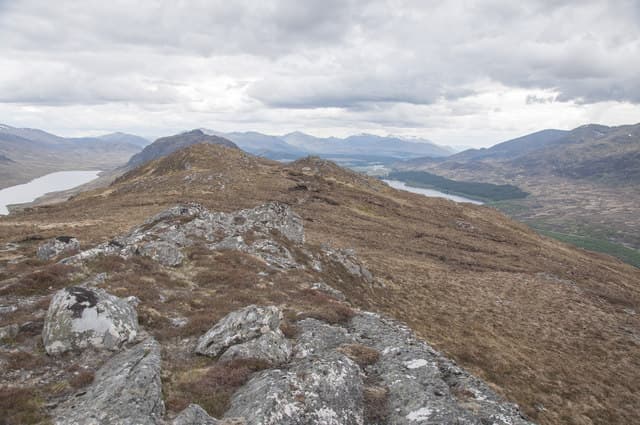
Binnein Shios (667m) — the eastern peak — is the lower of the two Binnein hills on the south side of Loch Laggan in NN48. Its pointed profile is one of the recognisable landmarks of the A86 road and the boulder cairn looks across the loch to the cliffs of Creag Meagaidh. A natural pairing with Binnein Shuas just to the west.
Quick facts
- Height
- 667.1m/ 2189ft
- Prominence
- 284 m
- Distance
- 13 km
- Ascent
- 547 m
- Time
- 3–6 hrs
- Grid ref
- NN492857
- Parking
- NN478837
- Nearest city
- Fort William· 40km
- Dogs
- Dogs on lead required near livestockDog-friendly guide ↗
Height and prominence cross-checked against the Database of British and Irish Hills (CC BY).
No GPX track yet
Walked this route? Share your track to help other walkers.
Standard route
heather moorland 60% · bog and rushes 25% · grassy summit 15%
Start from the Loch Laggan dam car park on the A86 and follow the forest track south-west along the loch shore. Branch off at the Lochside cottage and climb directly up the broad north shoulder on heather and short grass. The summit boulder caps a small rocky knot — the descent west to the Binnein Shuas col extends the day into a fine traverse.
Terrain
Loch-shore forest track followed by a sustained heather pull onto the north shoulder. The upper slopes are short grass and patches of slabby schist with a small rocky cap at the summit. The col with Binnein Shuas to the west is broad and grassy.
In winter
Loch Laggan sits in a cold-air trap and Binnein Shios holds frost for weeks. Snow cover varies — some winters give plastered cornices on the loch-facing flank, others leave the hill bare. The boulder summit makes a solid waypoint. SAIS Creag Meagaidh forecasts apply directly.
This hill is in the Creag Meagaidh SAIS forecast area. Check SAIS forecasts in winter (December–April).
Best time of year
Getting there
- Glasgow3h 34m
- Edinburgh3h 53m
OS maps: OS Landranger 34, OS Landranger 42
Mobile signal: Poor. Remote Loch Rannoch area; most networks barely reach.
Current conditions
Daylight Today
- Sunrise
- 04:43
- Sunset
- 22:04
- Civil dawn
- 03:42
- Civil dusk
- 23:05
NOAA Solar Calculator · 13 July 2026
Pair with
Curated multi-hill combinations from Binnein Shios.
Around Binnein Shios on the SCOT network
Getting there, basing yourself, and what to do off the hill.
Getting there: Dalwhinnie station
Highest mainline station; Drumochter Munros; Ben Alder approach
14km from the hill
tripscot.co.uk
On TripSCOTBase yourself in Fort William
Ben Nevis base, West Highland Line, gateway to Lochaber
40km from the hill
tripscot.co.uk
On TasteSCOTAfter the hill: Dalwhinnie
Dalwhinnie — Scotland's highest distillery on the Drumochter pass
14km from the hill
tastescot.co.uk
Binnein Shios — common questions
- What difficulty is Binnein Shios?
- On the OutdoorSCOT scale, Binnein Shios comes in at 3/5 — moderately challenging. Expect roughly 13km and 547m of ascent on the usual route — 3-6 hours for most parties. Terrain: Loch-shore forest track followed by a sustained heather pull onto the north shoulder.
- How prominent is Binnein Shios?
- Binnein Shios has 284m of topographic prominence — the height of its summit above the highest col connecting it to higher ground.
- Where should I park to climb Binnein Shios?
- Standard parking is at NN478837. Check the parking grid reference on an OS map before travel; informal laybys can fill on summer weekends.
- When should I climb Binnein Shios?
- The standard good-weather months for Binnein Shios are March, April, May, June, July, August, September, October, November. Outside those months, expect winter conditions on the high ground — full mountain kit, navigation skills, and a check of the SAIS avalanche forecast for the relevant region.
- Can I bring my dog up Binnein Shios?
- On a lead only — the route crosses ground with livestock or nesting-bird interest.
- What's mobile reception like on Binnein Shios?
- Poor. Remote Loch Rannoch area; most networks barely reach.
- Is Binnein Shios safe in winter?
- Loch Laggan sits in a cold-air trap and Binnein Shios holds frost for weeks. Snow cover varies — some winters give plastered cornices on the loch-facing flank, others leave the hill bare. The boulder summit makes a solid waypoint. SAIS Creag Meagaidh forecasts apply directly.
Get the OutdoorSCOT weekly
One email a week — new route, hill and bothy guides, seasonal conditions and the odd hard-won lesson. No spam, unsubscribe in one click.