Corbett · Central Highlands
The Fara
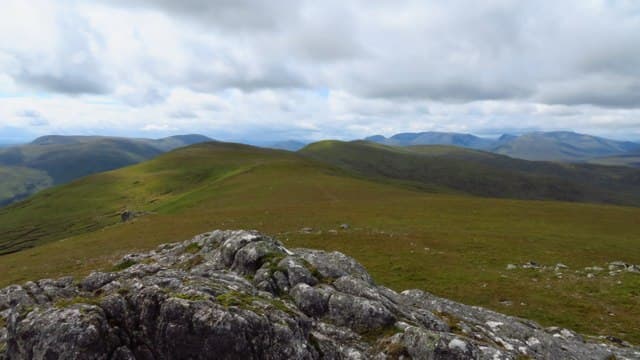
The Fara is the long whaleback ridge running south-west from Dalwhinnie above Loch Ericht — a six-kilometre line of moorland summit with the loch on one side and Glen Truim on the other. It is the kind of Corbett that gives more of a feel of remote upland Scotland than its modest difficulty suggests. The walking is gentle but the day is long, and the views across to Ben Alder are the payoff. A good early-season hill while the higher Munros still hold snow.
Quick facts
- Height
- 911.4m/ 2990ft
- Prominence
- 475 m
- Distance
- 18 km
- Ascent
- 750 m
- Time
- 4–7 hrs
- Grid ref
- NN598842
- Parking
- NN635849
- Nearest
- Fort William· Inverness 61km
- Dogs
- Dogs on lead required near livestockDog-friendly guide ↗
Height and prominence cross-checked against the Database of British and Irish Hills (CC BY).
No GPX track yet
Walked this route? Share your track to help other walkers.
Standard route
access path 15% · heather moorland 35% · plateau grass 40% · summit area 10%
Start in Dalwhinnie at the public car park near the distillery. Walk south-west along the road past the dam at the head of Loch Ericht, then onto a Land Rover track that climbs steeply onto the north-east end of the ridge. Once on the crest, follow the long broad ridge south-west over a series of subsidiary tops to the summit cairn. Most parties retrace their steps, but a one-way variant descends north into Glen Truim with a pickup at Drumochter. Allow 6–7 hours.
Terrain
Land Rover track for the first kilometre of climbing, then a broad grassy ridge with occasional peat hags. Going is generally good for a central Highland hill — drier than the Cairngorms because of the rain shadow. The ridge has several false tops; in cloud, navigation is straightforward but pacing matters.
In winter
A reasonable winter day for experienced hillwalkers — gradients are gentle and the route is hard to lose. Wind on the ridge can be ferocious; cold east winds in particular blast across from the Drumochter pass. Crampons are rarely essential on the gradient itself, but the iced Land Rover track on the climb up can be slippery.
This hill is in the Creag Meagaidh SAIS forecast area. Check SAIS forecasts in winter (December–April).
Best time of year
Getting there
- Glasgow3h 32m
- Edinburgh3h 44m
OS maps: OS Landranger 42
Mobile signal: Reasonable EE/Vodafone signal on the lower ridge near Dalwhinnie; patchy on the south-west end above Loch Ericht
Current conditions
Daylight Today
- Sunrise
- 04:42
- Sunset
- 22:03
- Civil dawn
- 03:42
- Civil dusk
- 23:04
NOAA Solar Calculator · 13 July 2026
Around The Fara on the SCOT network
Getting there, basing yourself, and what to do off the hill.
Getting there: Dalwhinnie station
Highest mainline station; Drumochter Munros; Ben Alder approach
4km from the hill
tripscot.co.uk
On TripSCOTBase yourself in Aviemore
Cairngorms base — Strathspey valley, ski centre, train
41km from the hill
tripscot.co.uk
On TasteSCOTAfter the hill: Dalwhinnie
Dalwhinnie — Scotland's highest distillery on the Drumochter pass
4km from the hill
tastescot.co.uk
The Fara — common questions
- What difficulty is The Fara?
- On the OutdoorSCOT scale, The Fara comes in at 2/5 — moderate. Expect roughly 18km and 750m of ascent on the usual route — 4-7 hours for most parties. Underfoot: Land Rover track for the first kilometre of climbing, then a broad grassy ridge with occasional peat hags.
- What is The Fara's prominence?
- 475m of prominence. That's the vertical drop from the summit to the col that links The Fara to the next higher ground.
- Where do I park for The Fara?
- Most walkers start from NN635849 near Fort William. Verify the grid reference on an OS map before you set off — space is tight on busy summer weekends.
- When is the best time to climb The Fara?
- May, June, July, August, September, October give the most reliable conditions on The Fara. Beyond that window the high ground turns wintry: carry full mountain kit, be confident navigating, and check the SAIS avalanche forecast for the area.
- Is The Fara dog-friendly?
- Yes, but dogs must be kept on a lead — there is livestock or ground-nesting bird interest on the route.
- Is there mobile signal on The Fara?
- Reasonable EE/Vodafone signal on the lower ridge near Dalwhinnie; patchy on the south-west end above Loch Ericht
- Is The Fara safe in winter?
- A reasonable winter day for experienced hillwalkers — gradients are gentle and the route is hard to lose. Wind on the ridge can be ferocious; cold east winds in particular blast across from the Drumochter pass. Crampons are rarely essential on the gradient itself, but the iced Land Rover track on the climb up can be slippery.
Get the OutdoorSCOT weekly
One email a week — new route, hill and bothy guides, seasonal conditions and the odd hard-won lesson. No spam, unsubscribe in one click.