Corbett · Central Highlands
An Dun
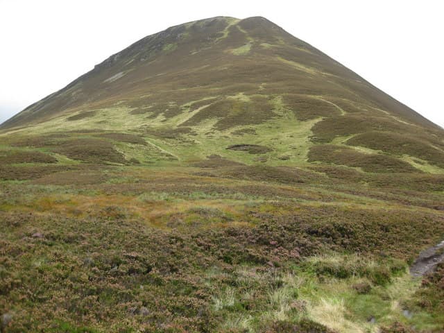
An Dun — "the fort", named for its distinctive flat-topped citadel profile when seen from the south — is a striking Corbett deep in the empty Gaick Forest country between Dalwhinnie and Blair Atholl. At 827m the summit is a tiny cairn on a wide grassy plateau, but the dramatic east and west faces drop steeply into the Gaick pass below, giving the hill a far more mountainous character than its rolling moorland neighbours. The view down the length of Loch an Duin is one of the great Gaick spectacles.
Quick facts
- Height
- 827.4m/ 2715ft
- Prominence
- 232 m
- Distance
- 15 km
- Ascent
- 728 m
- Time
- 5–7 hrs
- Grid ref
- NN716801
- Parking
- NN722704
- Nearest
- Fort William· Inverness 65km
- Dogs
- Dogs on lead required near livestockDog-friendly guide ↗
Height and prominence cross-checked against the Database of British and Irish Hills (CC BY).
No GPX track yet
Walked this route? Share your track to help other walkers.
Standard route
estate path 40% · open hillside 30% · plateau grass 20% · summit cairn 10%
The shortest line is via the Gaick pass from Dalnacardoch on the A9. Take the public path north through the Gaick estate for around 5km, then climb open heather slopes east up An Dun's south-west shoulder. Around 15km return with 728m of ascent — a bike on the path saves significant time. Often combined with A' Chaoirnich across the pass for a full Gaick day.
Terrain
The Gaick estate path is well-graded and bike-friendly through the pass. Off the path the south-west shoulder is short heather and grass, easier going than most of the Gaick. The summit plateau is broad short grass with the cairn at the highest point. The east and west faces are steep enough to demand care in mist — stay back from both edges. No exposed scrambling on the standard line.
In winter
A serious-feeling winter Corbett — the dramatic east and west faces hold snow in cornices after westerly storms and the path through the Gaick can become a deep snow channel. Avalanche risk exists on the steeper flanks but not on the standard south-west shoulder. Dalnacardoch lay-by is gritted; the path can be skiable in good snow years.
This hill is in the Creag Meagaidh SAIS forecast area. Check SAIS forecasts in winter (December–April).
Best time of year
Getting there
- Glasgow2h 27m
- Edinburgh3h 32m
OS maps: OS Landranger 42
Mobile signal: No signal in the Gaick interior; A9 lay-bys have reasonable coverage
Current conditions
Daylight Today
- Sunrise
- 04:48
- Sunset
- 21:57
- Civil dawn
- 03:50
- Civil dusk
- 22:55
NOAA Solar Calculator · 17 July 2026
Around An Dun on the SCOT network
Getting there, basing yourself, and what to do off the hill.
Getting there: Dalwhinnie station
Highest mainline station; Drumochter Munros; Ben Alder approach
10km from the hill
tripscot.co.uk
On TripSCOTBase yourself in Pitlochry
Perthshire base — Schiehallion, Beinn a Ghlo, Ben Vrackie
31km from the hill
tripscot.co.uk
On TasteSCOTAfter the hill: Dalwhinnie
Dalwhinnie — Scotland's highest distillery on the Drumochter pass
10km from the hill
tastescot.co.uk
An Dun — common questions
- How hard is An Dun?
- We grade An Dun at 3/5, which puts it in moderately challenging territory. The usual route is around 15km with 728m of climbing; allow 5-7 hours. Terrain: The Gaick estate path is well-graded and bike-friendly through the pass.
- How prominent is An Dun?
- An Dun has 232m of topographic prominence — the height of its summit above the highest col connecting it to higher ground.
- Where should I park to climb An Dun?
- Standard parking is at NN722704 near Fort William. Check the parking grid reference on an OS map before travel; informal laybys can fill on summer weekends.
- When should I climb An Dun?
- The standard good-weather months for An Dun are April, May, June, July, August, September, October. Outside those months, expect winter conditions on the high ground — full mountain kit, navigation skills, and a check of the SAIS avalanche forecast for the relevant region.
- Can I bring my dog up An Dun?
- On a lead only — the route crosses ground with livestock or nesting-bird interest.
- What's mobile reception like on An Dun?
- No signal in the Gaick interior; A9 lay-bys have reasonable coverage
- Is An Dun safe in winter?
- A serious-feeling winter Corbett — the dramatic east and west faces hold snow in cornices after westerly storms and the path through the Gaick can become a deep snow channel. Avalanche risk exists on the steeper flanks but not on the standard south-west shoulder. Dalnacardoch lay-by is gritted; the path can be skiable in good snow years.
Get the OutdoorSCOT weekly
One email a week — new route, hill and bothy guides, seasonal conditions and the odd hard-won lesson. No spam, unsubscribe in one click.