Graham · Central Highlands
Creag Ruadh
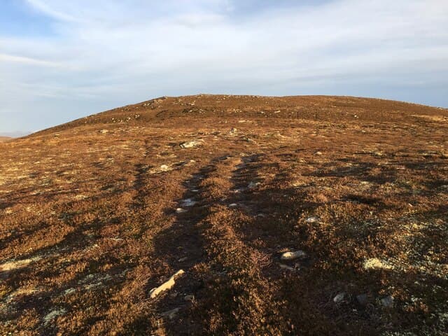
Creag Ruadh (658m) — the red crag — perches above Loch Laggan in the NN68 square, west of Sherramore. The small cairn occupies a heathery shoulder with the Ardverikie estate spread below; reddish granite outcrops on the south face give the hill its name.
Gaelic: “crag, red” · Pronunciation: krayg roo-ah
Quick facts
- Height
- 658.8m/ 2161ft
- Prominence
- 198 m
- Distance
- 13 km
- Ascent
- 540 m
- Time
- 3–6 hrs
- Grid ref
- NN685881
- Parking
- NN596897
- Nearest city
- Inverness· 57km
- Dogs
- Dogs on lead required near livestockDog-friendly guide ↗
Height and prominence cross-checked against the Database of British and Irish Hills (CC BY).
No GPX track yet
Walked this route? Share your track to help other walkers.
Standard route
heather moorland 65% · grass slopes 25% · rocky outcrops 10%
Begin from the parking near Sherramore on the south side of Loch Laggan. A landrover track climbs south into the forestry plantation before a break leads onto open hillside. Strike up the broad north-east shoulder on rough heather to gain the rolling crest, then follow it south-west to the small summit cairn.
Terrain
Forestry track, plantation break and open heather — straightforward in clear conditions. The crest is broad with several false tops; the true summit is the southernmost mound topped by a small cairn.
In winter
Snowfall on the Ardverikie side of Loch Laggan is patchy but consolidates into hard névé on north slopes. The forest provides shelter on approach; once on the open shoulder the wind from the loch can be relentless. A short winter day is genuinely tight here without an early start.
This hill is in the Creag Meagaidh SAIS forecast area. Check SAIS forecasts in winter (December–April).
Best time of year
Getting there
- Glasgow3h 37m
- Edinburgh3h 43m
OS maps: OS Landranger 35, OS Explorer 402
Mobile signal: Poor. Remote Sherramore / south Loch Laggan area; weak on most networks.
Current conditions
Daylight Today
- Sunrise
- 04:48
- Sunset
- 21:58
- Civil dawn
- 03:49
- Civil dusk
- 22:56
NOAA Solar Calculator · 17 July 2026
Around Creag Ruadh on the SCOT network
Getting there, basing yourself, and what to do off the hill.
Getting there: Dalwhinnie station
Highest mainline station; Drumochter Munros; Ben Alder approach
5km from the hill
tripscot.co.uk
On TripSCOTBase yourself in Aviemore
Cairngorms base — Strathspey valley, ski centre, train
33km from the hill
tripscot.co.uk
On TasteSCOTAfter the hill: Dalwhinnie
Dalwhinnie — Scotland's highest distillery on the Drumochter pass
6km from the hill
tastescot.co.uk
Creag Ruadh — common questions
- What difficulty is Creag Ruadh?
- On the OutdoorSCOT scale, Creag Ruadh comes in at 3/5 — moderately challenging. Expect roughly 13km and 540m of ascent on the usual route — 3-6 hours for most parties. Terrain: Forestry track, plantation break and open heather — straightforward in clear conditions.
- How prominent is Creag Ruadh?
- Creag Ruadh has 198m of topographic prominence — the height of its summit above the highest col connecting it to higher ground.
- Where should I park to climb Creag Ruadh?
- Standard parking is at NN596897. Check the parking grid reference on an OS map before travel; informal laybys can fill on summer weekends.
- When should I climb Creag Ruadh?
- The standard good-weather months for Creag Ruadh are March, April, May, June, July, August, September, October, November. Outside those months, expect winter conditions on the high ground — full mountain kit, navigation skills, and a check of the SAIS avalanche forecast for the relevant region.
- Can I bring my dog up Creag Ruadh?
- On a lead only — the route crosses ground with livestock or nesting-bird interest.
- What's mobile reception like on Creag Ruadh?
- Poor. Remote Sherramore / south Loch Laggan area; weak on most networks.
- Is Creag Ruadh safe in winter?
- Snowfall on the Ardverikie side of Loch Laggan is patchy but consolidates into hard névé on north slopes. The forest provides shelter on approach; once on the open shoulder the wind from the loch can be relentless. A short winter day is genuinely tight here without an early start.
Get the OutdoorSCOT weekly
One email a week — new route, hill and bothy guides, seasonal conditions and the odd hard-won lesson. No spam, unsubscribe in one click.