Graham · Central Highlands
Creag Liath
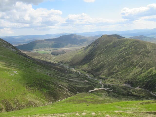
A long grey crag on the southern edge of the Monadhliath above Laggan village, looking over Strath Mashie to the Creag Meagaidh range. The crag faces above the road are favoured nesting cliffs and the summit ridge gives surprisingly long views east toward the Cairngorms.
Gaelic: “crag, grey” · Pronunciation: krayg lee-ah
Quick facts
- Height
- 743.5m/ 2439ft
- Prominence
- 190 m
- Distance
- 14 km
- Ascent
- 609 m
- Time
- 4–7 hrs
- Grid ref
- NH663007
- Parking
- NN615943
- Nearest city
- Inverness· 44km
- Dogs
- Dogs on lead required near livestockDog-friendly guide ↗
Height and prominence cross-checked against the Database of British and Irish Hills (CC BY).
No GPX track yet
Walked this route? Share your track to help other walkers.
Standard route
road access 15% · bog and heather 45% · grassy upper slopes 30% · summit area 10%
From the small layby on the minor road near Crathie, take the path through woodland then breast the steep flank just east of the main crag to gain the broad summit dome. A grassy stroll along the ridge reaches the highest outcrop.
Terrain
Wet birch wood at the foot, then trackless steep grass and bilberry to the crag rim. The upper plateau gives short grass with scattered schist outcrops.
In winter
The north-facing crag holds ice well into spring and is a known winter climbing venue. Walkers on the easy line stay clear of the crag-top cornice but should be wary of corniced edges in any northerly wind direction.
This hill is in the Creag Meagaidh SAIS forecast area. Check SAIS forecasts in winter (December–April).
Best time of year
Getting there
- Glasgow3h 53m
- Edinburgh3h 58m
OS maps: OS Landranger 35
Mobile signal: No signal near Loch Laggan/Drumochter area
Current conditions
Daylight Today
- Sunrise
- 04:41
- Sunset
- 22:04
- Civil dawn
- 03:40
- Civil dusk
- 23:06
NOAA Solar Calculator · 13 July 2026
On a long-distance route
Creag Liath sits within 5km of these named long-distance walks — useful for trail-pack rest days or section extensions.
Around Creag Liath on the SCOT network
Getting there, basing yourself, and what to do off the hill.
Getting there: Kingussie station
Cairngorms south side; Glen Feshie; Insh Marshes; Monadhliath access
9km from the hill
tripscot.co.uk
On TripSCOTBase yourself in Aviemore
Cairngorms base — Strathspey valley, ski centre, train
26km from the hill
tripscot.co.uk
On TasteSCOTAfter the hill: Dalwhinnie
Dalwhinnie — Scotland's highest distillery on the Drumochter pass
16km from the hill
tastescot.co.uk
Creag Liath — common questions
- Is Creag Liath a hard climb?
- Creag Liath is rated 4/5 (challenging) on the OutdoorSCOT scale. The standard route covers about 14km with 609m of ascent and takes most walkers 4-7 hours. Terrain: Wet birch wood at the foot, then trackless steep grass and bilberry to the crag rim.
- How prominent is Creag Liath?
- Creag Liath has 190m of topographic prominence — the height of its summit above the highest col connecting it to higher ground.
- Where should I park to climb Creag Liath?
- Standard parking is at NN615943. Check the parking grid reference on an OS map before travel; informal laybys can fill on summer weekends.
- When should I climb Creag Liath?
- The standard good-weather months for Creag Liath are April, May, June, July, August, September, October. Outside those months, expect winter conditions on the high ground — full mountain kit, navigation skills, and a check of the SAIS avalanche forecast for the relevant region.
- Can I bring my dog up Creag Liath?
- On a lead only — the route crosses ground with livestock or nesting-bird interest.
- What's mobile reception like on Creag Liath?
- No signal near Loch Laggan/Drumochter area
- Is Creag Liath safe in winter?
- The north-facing crag holds ice well into spring and is a known winter climbing venue. Walkers on the easy line stay clear of the crag-top cornice but should be wary of corniced edges in any northerly wind direction.
Get the OutdoorSCOT weekly
One email a week — new route, hill and bothy guides, seasonal conditions and the odd hard-won lesson. No spam, unsubscribe in one click.