Corbett · Central Highlands
Carn an Fhreiceadain
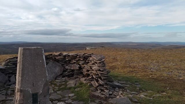
Càrn an Fhreiceadain — 'the watching cairn' — is the 878m Corbett rising directly above Kingussie at the south-east corner of the Monadhliath. The mountain was used as a vantage point by 17th-century watchmen who scanned for raiding cattle drovers coming down from the Cairngorms, hence the name. The 4WD estate track that runs from Kingussie to the summit is one of the more direct vehicle-track-to-summit lines on any Scottish Corbett. Views from the trig pillar look south across the Spey valley to Cairn Gorm and east to the Cairnwell passes.
Quick facts
- Height
- 877.7m/ 2880ft
- Prominence
- 173 m
- Distance
- 16 km
- Ascent
- 600 m
- Time
- 3–6 hrs
- Grid ref
- NH725071
- Parking
- NH758007
- Nearest city
- Inverness· 39km
- Dogs
- Dogs on lead required near livestockDog-friendly guide ↗
Height and prominence cross-checked against the Database of British and Irish Hills (CC BY).
No GPX track yet
Walked this route? Share your track to help other walkers.
Standard route
hillside path 30% · heather moorland 40% · grassy plateau 20% · summit area 10%
Park in Kingussie (NH758007) at the public car park behind the High Street. Walk west through the town and pick up the Old Logie track that climbs north onto the moorland behind the town. Follow the estate Land Rover track all the way to the summit trig point — a long, gentle gradient with no route-finding difficulty. The descent reverses the outward line. Allow 5–6 hours.
Terrain
The most track-walking-friendly Corbett in central Scotland — a Land Rover route runs from Kingussie almost to the summit. Drier underfoot than the western Highlands, occasional peat patches. The summit area has a trig pillar inside a stone shelter — useful in any wind.
In winter
An accessible winter Corbett — the long track gives reliable navigation under cover, and snow lies on the broad upper plateau from December through March. Cold easterlies funnelling along the Spey valley can be brutal on the summit; the trig shelter is genuinely useful for a brief brew stop. The route is hard to lose in cloud, making this a reasonable choice in poor visibility.
This hill is in the Creag Meagaidh SAIS forecast area. Check SAIS forecasts in winter (December–April).
Best time of year
Getting there
- Glasgow3h 1m
- Edinburgh3h 3m
OS maps: OS Landranger 35
Mobile signal: Reasonable signal near Kingussie; 2 bars intermittent on the summit
Current conditions
Daylight Today
- Sunrise
- 04:40
- Sunset
- 22:04
- Civil dawn
- 03:38
- Civil dusk
- 23:06
NOAA Solar Calculator · 13 July 2026
Pair with
Curated multi-hill combinations from Carn an Fhreiceadain.
On a long-distance route
Carn an Fhreiceadain sits within 5km of these named long-distance walks — useful for trail-pack rest days or section extensions.
Around Carn an Fhreiceadain on the SCOT network
Getting there, basing yourself, and what to do off the hill.
Getting there: Kingussie station
Cairngorms south side; Glen Feshie; Insh Marshes; Monadhliath access
7km from the hill
tripscot.co.uk
On TripSCOTBase yourself in Aviemore
Cairngorms base — Strathspey valley, ski centre, train
18km from the hill
tripscot.co.uk
On TasteSCOTAfter the hill: Dalwhinnie
Dalwhinnie — Scotland's highest distillery on the Drumochter pass
24km from the hill
tastescot.co.uk
Carn an Fhreiceadain — common questions
- What difficulty is Carn an Fhreiceadain?
- On the OutdoorSCOT scale, Carn an Fhreiceadain comes in at 2/5 — moderate. Expect roughly 16km and 600m of ascent on the usual route — 3-6 hours for most parties. Terrain: The most track-walking-friendly Corbett in central Scotland — a Land Rover route runs from Kingussie almost to the summit.
- How prominent is Carn an Fhreiceadain?
- Carn an Fhreiceadain has 173m of topographic prominence — the height of its summit above the highest col connecting it to higher ground.
- Where should I park to climb Carn an Fhreiceadain?
- Standard parking is at NH758007. Check the parking grid reference on an OS map before travel; informal laybys can fill on summer weekends.
- When should I climb Carn an Fhreiceadain?
- The standard good-weather months for Carn an Fhreiceadain are May, June, July, August, September, October. Outside those months, expect winter conditions on the high ground — full mountain kit, navigation skills, and a check of the SAIS avalanche forecast for the relevant region.
- Can I bring my dog up Carn an Fhreiceadain?
- On a lead only — the route crosses ground with livestock or nesting-bird interest.
- What's mobile reception like on Carn an Fhreiceadain?
- Reasonable signal near Kingussie; 2 bars intermittent on the summit
- Is Carn an Fhreiceadain safe in winter?
- An accessible winter Corbett — the long track gives reliable navigation under cover, and snow lies on the broad upper plateau from December through March. Cold easterlies funnelling along the Spey valley can be brutal on the summit; the trig shelter is genuinely useful for a brief brew stop. The route is hard to lose in cloud, making this a reasonable choice in poor visibility.
Get the OutdoorSCOT weekly
One email a week — new route, hill and bothy guides, seasonal conditions and the odd hard-won lesson. No spam, unsubscribe in one click.