Corbett · Central Highlands
Geal-charn Mor
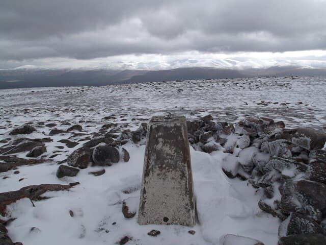
Geal-charn Mòr — 'the big white cairn' — is the 824m Corbett rising above Aviemore on the north side of the Spey valley. The mountain forms part of the Burma Road skyline that drivers see when approaching Aviemore from the south — a long broad ridge of pale stones and short grass typical of the eastern Monadhliath. The summit gives a clean view across the Spey to the main Cairngorm plateau, with the railway and the A9 stretched out below.
Gaelic: “white, cairn-topped hill, big” · Pronunciation: gyal charn more
Quick facts
- Height
- 824.1m/ 2704ft
- Prominence
- 228 m
- Distance
- 13 km
- Ascent
- 580 m
- Time
- 3–5 hrs
- Grid ref
- NH836123
- Parking
- NH883102
- Nearest city
- Inverness· 37km
- Dogs
- Dogs on lead required near livestockDog-friendly guide ↗
Height and prominence cross-checked against the Database of British and Irish Hills (CC BY).
No GPX track yet
Walked this route? Share your track to help other walkers.
Standard route
estate track 25% · heather moorland 40% · plateau grass 25% · summit area 10%
Park at the small car park at the start of the Burma Road near Lynwilg, just south of Aviemore (NH883102). Walk north-west along the Burma Road — the old military-built track climbing toward Sluggan — for around 4km, gaining height steadily. Where the track contours, leave it and climb west onto Geal-charn Mòr's broad east ridge. The summit trig pillar sits inside a small stone shelter. Allow 5–6 hours.
Terrain
The Burma Road is one of the best-built hill tracks in central Scotland — fast walking. Above the track the ground is short grass and pale stones; a vague path leads to the summit. The summit shelter is welcome in any easterly wind. Drier than the western hills thanks to the rain shadow.
In winter
Snow lies on the broad summit through January and February. The Burma Road is generally hard-frozen in cold spells — fast going under crampons. Cold easterlies from the Cairngorms can be ferocious on the open plateau; the summit shelter is genuinely useful. A friendly winter Corbett with a reliable Aviemore start.
This hill is in the Creag Meagaidh SAIS forecast area. Check SAIS forecasts in winter (December–April).
Best time of year
Getting there
- Glasgow3h 10m
- Edinburgh3h 4m
OS maps: OS Landranger 35
Mobile signal: Intermittent signal above Kingussie; 1-2 bars on the high ground
Current conditions
Daylight Today
- Sunrise
- 04:39
- Sunset
- 22:04
- Civil dawn
- 03:37
- Civil dusk
- 23:06
NOAA Solar Calculator · 13 July 2026
Pair with
Curated multi-hill combinations from Geal-charn Mor.
On a long-distance route
Geal-charn Mor sits within 5km of these named long-distance walks — useful for trail-pack rest days or section extensions.
Around Geal-charn Mor on the SCOT network
Getting there, basing yourself, and what to do off the hill.
Getting there: Aviemore station
Cairngorm plateau; Lairig Ghru; Speyside Way; Glenmore
6km from the hill
tripscot.co.uk
On TripSCOTBase yourself in Aviemore
Cairngorms base — Strathspey valley, ski centre, train
6km from the hill
tripscot.co.uk
On TasteSCOTAfter the hill: Tomatin
Tomatin — large Highland distillery just off the A9, south of Inverness
18km from the hill
tastescot.co.uk
Geal-charn Mor — common questions
- How hard is Geal-charn Mor?
- We grade Geal-charn Mor at 2/5, which puts it in moderate territory. The usual route is around 13km with 580m of climbing; allow 3-5 hours. Underfoot: The Burma Road is one of the best-built hill tracks in central Scotland — fast walking.
- What is Geal-charn Mor's prominence?
- 228m of prominence. That's the vertical drop from the summit to the col that links Geal-charn Mor to the next higher ground.
- Where do I park for Geal-charn Mor?
- Most walkers start from NH883102. Verify the grid reference on an OS map before you set off — space is tight on busy summer weekends.
- When is the best time to climb Geal-charn Mor?
- April, May, June, July, August, September, October give the most reliable conditions on Geal-charn Mor. Beyond that window the high ground turns wintry: carry full mountain kit, be confident navigating, and check the SAIS avalanche forecast for the area.
- Is Geal-charn Mor dog-friendly?
- Yes, but dogs must be kept on a lead — there is livestock or ground-nesting bird interest on the route.
- Is there mobile signal on Geal-charn Mor?
- Intermittent signal above Kingussie; 1-2 bars on the high ground
- Is Geal-charn Mor safe in winter?
- Snow lies on the broad summit through January and February. The Burma Road is generally hard-frozen in cold spells — fast going under crampons. Cold easterlies from the Cairngorms can be ferocious on the open plateau; the summit shelter is genuinely useful. A friendly winter Corbett with a reliable Aviemore start.
Get the OutdoorSCOT weekly
One email a week — new route, hill and bothy guides, seasonal conditions and the odd hard-won lesson. No spam, unsubscribe in one click.