Munro · Cairngorms
Braeriach
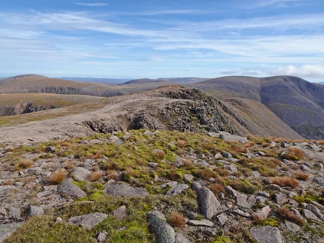
Braeriach is the third-highest Munro at 1296m, sitting on the western side of the Lairig Ghru opposite Ben Macdui. The summit cairn perches right on the edge of one of the most extensive corrie systems in Britain — Coire Bhrochain, Coire an Lochain Uaine and the Garbh Choire — a continuous 1.5km arc of cliffs and snow patches that hold permanent névé well into July most years. The hill's name means "the brindled upland" and the views across the Lairig Ghru to Macdui, with the Falls of Dee plunging into the An Garbh Choire below the summit, are among the great Cairngorm spectacles.
Quick facts
- Height
- 1296m/ 4252ft
- Prominence
- 461 m
- Distance
- 20 km
- Ascent
- 1140 m
- Time
- 7–10 hrs
- Grid ref
- NN953999
- Parking
- NH985075
- Nearest city
- Inverness· 54km
- Dogs
- Dogs on lead required near livestockDog-friendly guide ↗
Height and prominence cross-checked against the Database of British and Irish Hills (CC BY).
No GPX track yet
Walked this route? Share your track to help other walkers.
Standard route
Forest / moorland path 35% · Mountain path 35% · Plateau / boulder field 30%
The traditional approach is from Whitewell or Coylumbridge near Aviemore via the Chalamain Gap and the Sron na Lairige path — around 20km return with 1140m of ascent. Strong walkers continue the classic horseshoe round to Cairn Toul and Sgor an Lochain Uaine, accepting roughly 30km and 1700m for the full day. The southern approach from Linn of Dee via Glen Luibeg and the Lairig Ghru is similar in length but shorter on the hill itself.
Terrain
The Rothiemurchus / Sron na Lairige path is well-built through pinewoods and onto open hill. The Chalamain Gap is a notoriously awkward boulder-hop where stable footwork matters. The summit plateau is wide and undulating with granite gravel and patches of moss; the cairn sits within a few metres of the corrie edge. The corrie rims are unfenced and undercut — keep well back, particularly with cornice overhang in spring.
In winter
A serious winter mountain in every sense. Cornices form continuously along the corrie rim from October onwards and have collapsed under walkers; the Garbh Choire face holds Grade III–V winter climbs. The Chalamain Gap is hazardous under fresh snow as the boulders are masked. Plan precise bearings off the plateau, carry full kit and check SAIS Northern Cairngorms before going.
This hill is in the Northern Cairngorms SAIS forecast area. Check SAIS forecasts in winter (December–April).
Best time of year
Getting there
- Glasgow3h 58m
- Edinburgh3h 45m
OS maps: OS Landranger 36, OS Landranger 43
Mobile signal: Limited signal from Whitewell / Rothiemurchus. No reliable signal above treeline. Summit typically has no signal. Plan navigation without phone dependency.
Current conditions
Daylight Today
- Sunrise
- 04:56
- Sunset
- 21:47
- Civil dawn
- 04:00
- Civil dusk
- 22:43
NOAA Solar Calculator · 23 July 2026
Pair with
Curated multi-hill combinations from Braeriach.
Around Braeriach on the SCOT network
Getting there, basing yourself, and what to do off the hill.
Getting there: Aviemore station
Cairngorm plateau; Lairig Ghru; Speyside Way; Glenmore
14km from the hill
tripscot.co.uk
On TripSCOTBase yourself in Aviemore
Cairngorms base — Strathspey valley, ski centre, train
14km from the hill
tripscot.co.uk
On TasteSCOTAfter the hill: Tomintoul
Tomintoul village — the gentle Speysider in the eastern Cairngorms
28km from the hill
tastescot.co.uk
Braeriach — common questions
- Is Braeriach a hard climb?
- Braeriach is rated 4/5 (challenging) on the OutdoorSCOT scale. The standard route covers about 20km with 1140m of ascent and takes most walkers 7-10 hours. Underfoot: The Rothiemurchus / Sron na Lairige path is well-built through pinewoods and onto open hill.
- What is Braeriach's prominence?
- 461m of prominence. That's the vertical drop from the summit to the col that links Braeriach to the next higher ground.
- Where do I park for Braeriach?
- Most walkers start from NH985075. Verify the grid reference on an OS map before you set off — space is tight on busy summer weekends.
- When is the best time to climb Braeriach?
- May, June, July, August, September, October give the most reliable conditions on Braeriach. Beyond that window the high ground turns wintry: carry full mountain kit, be confident navigating, and check the SAIS avalanche forecast for the area.
- Is Braeriach dog-friendly?
- Yes, but dogs must be kept on a lead — there is livestock or ground-nesting bird interest on the route.
- Is there mobile signal on Braeriach?
- Limited signal from Whitewell / Rothiemurchus. No reliable signal above treeline. Summit typically has no signal. Plan navigation without phone dependency.
- Is Braeriach safe in winter?
- A serious winter mountain in every sense. Cornices form continuously along the corrie rim from October onwards and have collapsed under walkers; the Garbh Choire face holds Grade III–V winter climbs. The Chalamain Gap is hazardous under fresh snow as the boulders are masked. Plan precise bearings off the plateau, carry full kit and check SAIS Northern Cairngorms before going.
Get the OutdoorSCOT weekly
One email a week — new route, hill and bothy guides, seasonal conditions and the odd hard-won lesson. No spam, unsubscribe in one click.