Munro · Cairngorms
Sgor an Lochain Uaine
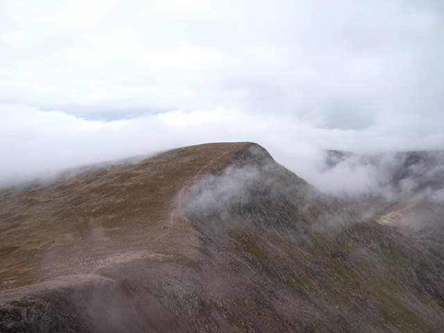
Sgor an Lochain Uaine — almost universally known as the Angel's Peak — is the small but striking 1258m Munro between Cairn Toul and Braeriach, perched on the rim of a perfect glacial bowl that holds the green lochan (Lochan Uaine) that gives the hill its name. It is one of the four highest summits in Britain and one of only nine Munros over 4000ft (1258m), yet it is almost never climbed on its own — its position between two giants means it is invariably tagged onto the great Cairngorm horseshoe round.
Gaelic: “sharp peak, the, small loch” · Pronunciation: skor an loch-een uaine
Quick facts
- Height
- 1258m/ 4127ft
- Prominence
- 118 m
- Distance
- 20 km
- Ascent
- 1107 m
- Time
- 6–10 hrs
- Grid ref
- NN954976
- Parking
- NH985075
- Nearest city
- Inverness· 56km
- Dogs
- Dogs on lead required near livestockDog-friendly guide ↗
Height and prominence cross-checked against the Database of British and Irish Hills (CC BY).
No GPX track yet
Walked this route? Share your track to help other walkers.
Standard route
Glen / stalkers path 45% · Mountain path 25% · Plateau / boulder field 30%
Best done as part of the four-Munro horseshoe from Whitewell (Aviemore), taking in Braeriach, Sgor an Lochain Uaine, Cairn Toul and the southern tops of the Garbh Choire. Around 30km and 1800m of ascent for the full round. The 20km/1107m figure in the database is for an Angel's Peak detour from a Cairn Toul approach via the Lairig Ghru. The summit itself is only 500m from Cairn Toul along the plateau rim — a 15-minute extra walk on top of the bigger hill.
Terrain
The plateau ridge between Cairn Toul and the Angel's Peak runs along the lip of Coire an Lochain Uaine — narrow enough to demand care, broad enough not to need scrambling. Granite gravel and patches of moss campion form the summit surface. The Lochan Uaine itself is over 200m below; the corrie rim is unfenced and cornice-prone in winter and spring.
In winter
A full alpine setting in winter — the cliffs around Lochan Uaine are a major Scottish winter climbing venue with Grade III-V routes, and cornices form continuously along the entire corrie rim from October. Whiteout navigation on the connecting plateau is the chief risk for walkers. Avoid the corrie edge in any conditions where cornice extent is uncertain.
This hill is in the Northern Cairngorms SAIS forecast area. Check SAIS forecasts in winter (December–April).
Best time of year
Getting there
- Glasgow3h 55m
- Edinburgh3h 42m
OS maps: OS Landranger 36, OS Landranger 43
Mobile signal: No signal on the approach or summit — among the remotest Munros for connectivity. Emergency signal may be available on highest ground in favourable conditions. Navigation must be fully map-and-compass based.
Current conditions
Daylight Today
- Sunrise
- 04:56
- Sunset
- 21:47
- Civil dawn
- 04:00
- Civil dusk
- 22:43
NOAA Solar Calculator · 23 July 2026
Pair with
Curated multi-hill combinations from Sgor an Lochain Uaine.
Around Sgor an Lochain Uaine on the SCOT network
Getting there, basing yourself, and what to do off the hill.
Getting there: Aviemore station
Cairngorm plateau; Lairig Ghru; Speyside Way; Glenmore
16km from the hill
tripscot.co.uk
On TripSCOTBase yourself in Aviemore
Cairngorms base — Strathspey valley, ski centre, train
16km from the hill
tripscot.co.uk
On TasteSCOTAfter the hill: Tomintoul
Tomintoul village — the gentle Speysider in the eastern Cairngorms
30km from the hill
tastescot.co.uk
Sgor an Lochain Uaine — common questions
- How hard is Sgor an Lochain Uaine?
- We grade Sgor an Lochain Uaine at 4/5, which puts it in challenging territory. The usual route is around 20km with 1107m of climbing; allow 6-10 hours. Ground conditions: The plateau ridge between Cairn Toul and the Angel's Peak runs along the lip of Coire an Lochain Uaine — narrow enough to demand care, broad enough not to need scrambling.
- How much drop does Sgor an Lochain Uaine have?
- The drop is 118m: measured from the summit of Sgor an Lochain Uaine down to the saddle joining it to higher terrain.
- Where's the parking for Sgor an Lochain Uaine?
- Park at NH985075. Double-check the grid reference on an OS map first; informal laybys here fill early in high season.
- What's the best month to climb Sgor an Lochain Uaine?
- Aim for May, June, July, August, September, October on Sgor an Lochain Uaine. In the remaining months treat it as a winter hill — full kit, solid navigation, and a look at the relevant SAIS avalanche forecast before you go.
- Can dogs go up Sgor an Lochain Uaine?
- Dogs are fine on a lead. The route passes livestock or ground-nesting bird habitat, so keep them close throughout.
- Will I get phone signal on Sgor an Lochain Uaine?
- No signal on the approach or summit — among the remotest Munros for connectivity. Emergency signal may be available on highest ground in favourable conditions. Navigation must be fully map-and-compass based.
- Is Sgor an Lochain Uaine safe in winter?
- A full alpine setting in winter — the cliffs around Lochan Uaine are a major Scottish winter climbing venue with Grade III-V routes, and cornices form continuously along the entire corrie rim from October. Whiteout navigation on the connecting plateau is the chief risk for walkers. Avoid the corrie edge in any conditions where cornice extent is uncertain.
Get the OutdoorSCOT weekly
One email a week — new route, hill and bothy guides, seasonal conditions and the odd hard-won lesson. No spam, unsubscribe in one click.