Corbett · Cairngorms
Creag Mhor
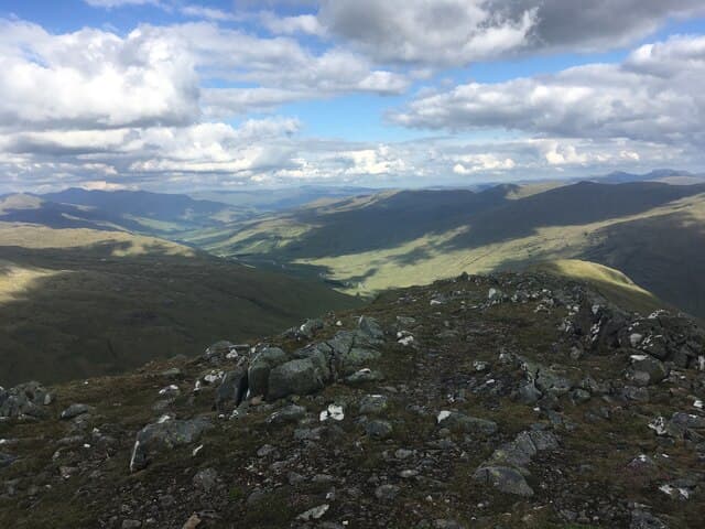
Creag Mhor — there are several of this common name across the Highlands — is the 895m Corbett in the rolling country east of the Cairngorm plateau, between Glen Avon and the headwaters of the River Don. This is heather-and-granite Cairngorm fringe country rather than the high arctic plateau, and the hill carries a small granite tor at the highest point. Long approaches across heather and rough estate ground keep visitor numbers low; on a clear day the view back across Strath Avon to the Cairngorm tops is the day's real prize.
Gaelic: “crag, big” · Pronunciation: krayg vore
Quick facts
- Height
- 895m/ 2936ft
- Prominence
- 167 m
- Distance
- 16 km
- Ascent
- 788 m
- Time
- 5–8 hrs
- Grid ref
- NJ057047
- Parking
- NJ047049
- Nearest city
- Inverness· 56km
- Dogs
- Dogs on lead required near livestockDog-friendly guide ↗
Height and prominence cross-checked against the Database of British and Irish Hills (CC BY).
No GPX track yet
Walked this route? Share your track to help other walkers.
Standard route
estate track 30% · deep heather 40% · broken granite 20% · summit tor 10%
The most direct line is from a track end on the Glen Avon estate road, working in from Tomintoul or via the Don headwaters. From the end of useful track, open heather and rough grass climb steadily onto the broad south-east ridge. The summit tor sits at the high point of a broad dome. Around 16km return with 788m of ascent. Access here depends on estate stalking activity from August to October — check ahead. There are no built paths on the hill itself.
Terrain
Estate tracks lead in well but quickly become rough. Above the tracks the going is deep heather and peat hag — slow and tiring. The summit dome itself is broken granite and short heather with the tor cairn at the highest of several minor bumps. No exposure, but plenty of opportunity to wander off-course on the broad top in poor visibility.
In winter
A relatively low Cairngorm-fringe Corbett that picks up reliable snow from December to March. Drifting on the broad summit dome can fill in the few visible features quickly. No technical winter ground, but the navigation across featureless plateau in whiteout demands competence with compass and pacing. The estate roads are not gritted; check conditions before driving in.
This hill is in the Northern Cairngorms SAIS forecast area. Check SAIS forecasts in winter (December–April).
Best time of year
Getting there
- Glasgow3h 7m
- Edinburgh3h 49m
OS maps: OS Landranger 36
Mobile signal: Poor signal in Glen Lochay; brief coverage on the summit in clear conditions
Current conditions
Daylight Today
- Sunrise
- 04:38
- Sunset
- 22:02
- Civil dawn
- 03:36
- Civil dusk
- 23:04
NOAA Solar Calculator · 13 July 2026
Around Creag Mhor on the SCOT network
Getting there, basing yourself, and what to do off the hill.
Getting there: Aviemore station
Cairngorm plateau; Lairig Ghru; Speyside Way; Glenmore
18km from the hill
tripscot.co.uk
On TripSCOTBase yourself in Aviemore
Cairngorms base — Strathspey valley, ski centre, train
18km from the hill
tripscot.co.uk
On TasteSCOTAfter the hill: Tomintoul
Tomintoul village — the gentle Speysider in the eastern Cairngorms
17km from the hill
tastescot.co.uk
Creag Mhor — common questions
- How hard is Creag Mhor?
- We grade Creag Mhor at 3/5, which puts it in moderately challenging territory. The usual route is around 16km with 788m of climbing; allow 5-8 hours. Terrain: Estate tracks lead in well but quickly become rough.
- How prominent is Creag Mhor?
- Creag Mhor has 167m of topographic prominence — the height of its summit above the highest col connecting it to higher ground.
- Where should I park to climb Creag Mhor?
- Standard parking is at NJ047049. Check the parking grid reference on an OS map before travel; informal laybys can fill on summer weekends.
- When should I climb Creag Mhor?
- The standard good-weather months for Creag Mhor are May, June, July, August, September, October. Outside those months, expect winter conditions on the high ground — full mountain kit, navigation skills, and a check of the SAIS avalanche forecast for the relevant region.
- Can I bring my dog up Creag Mhor?
- On a lead only — the route crosses ground with livestock or nesting-bird interest.
- What's mobile reception like on Creag Mhor?
- Poor signal in Glen Lochay; brief coverage on the summit in clear conditions
- Is Creag Mhor safe in winter?
- A relatively low Cairngorm-fringe Corbett that picks up reliable snow from December to March. Drifting on the broad summit dome can fill in the few visible features quickly. No technical winter ground, but the navigation across featureless plateau in whiteout demands competence with compass and pacing. The estate roads are not gritted; check conditions before driving in.
Get the OutdoorSCOT weekly
One email a week — new route, hill and bothy guides, seasonal conditions and the odd hard-won lesson. No spam, unsubscribe in one click.