Munro · Cairngorms
Beinn Mheadhoin
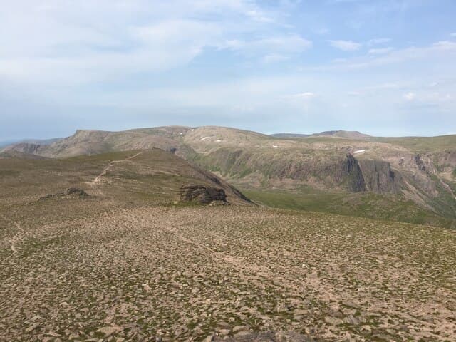
Beinn Mheadhoin — "the middle hill", pronounced roughly "vain" — is the 1182m Munro at the heart of the central Cairngorms, overlooking Loch Avon and the great basin of the Garbh Choire. The hill is famous for its summit: a series of huge granite tors that erupt from the plateau like miniature Wyoming rock formations. You climb a short Grade 1 scramble onto the highest tor to claim the true summit, an experience unique among Scottish Munros. The view down to Loch Avon and the Shelter Stone climbing routes is one of the great Cairngorm panoramas.
Quick facts
- Height
- 1182.9m/ 3881ft
- Prominence
- 254 m
- Distance
- 19 km
- Ascent
- 1041 m
- Time
- 6–9 hrs
- Grid ref
- NJ024016
- Parking
- NO062898
- Nearest city
- Inverness· 56km
- Dogs
- Dogs on lead required near livestockDog-friendly guide ↗
Height and prominence cross-checked against the Database of British and Irish Hills (CC BY).
No GPX track yet
Walked this route? Share your track to help other walkers.
Standard route
Forest / glen path 40% · Mountain path 35% · Granite tor scramble 25%
The classic line is from Linn of Dee via Glen Lui to Derry Lodge, then up Coire Etchachan to Loch Etchachan and the broad ridge that links to the summit tor. Around 22km return with 1041m of ascent. The northern approach via Cairn Gorm Coire Cas, Loch Avon and the Saddle is similar in length but adds a Loch Avon visit. Often combined with Derry Cairngorm or Ben Macdui for a multi-Munro day.
Terrain
The Glen Lui and Coire Etchachan paths are well-built. The plateau between Loch Etchachan and the summit is open granite gravel and short moss. The summit itself is a cluster of huge weathered tors; a short Grade 1 scramble onto the highest tor is required to bag the true top. No exposure unless you scramble. The Loch Avon basin to the north is unfenced and crag-broken on all sides.
In winter
In winter the summit tor is rime-encrusted and the short scramble onto it can become a serious snow-and-ice move. The plateau itself is a major navigation challenge — the same featureless arctic ground as Ben Macdui next door. Cornices form on the Loch Avon side. SAIS Northern Cairngorms applies; an experienced winter-walking party only.
This hill is in the Northern Cairngorms SAIS forecast area. Check SAIS forecasts in winter (December–April).
Best time of year
Getting there
- Glasgow3h 2m
- Edinburgh3h 46m
OS maps: OS Landranger 36
Mobile signal: No signal above the Derry Lodge treeline. Limited signal at Linn of Dee car park. Plan navigation and communication without phone dependency.
Current conditions
Daylight Today
- Sunrise
- 04:55
- Sunset
- 21:47
- Civil dawn
- 03:59
- Civil dusk
- 22:43
NOAA Solar Calculator · 23 July 2026
Pair with
Curated multi-hill combinations from Beinn Mheadhoin.
Around Beinn Mheadhoin on the SCOT network
Getting there, basing yourself, and what to do off the hill.
Getting there: Aviemore station
Cairngorm plateau; Lairig Ghru; Speyside Way; Glenmore
17km from the hill
tripscot.co.uk
On TripSCOTBase yourself in Aviemore
Cairngorms base — Strathspey valley, ski centre, train
17km from the hill
tripscot.co.uk
On TasteSCOTAfter the hill: Tomintoul
Tomintoul village — the gentle Speysider in the eastern Cairngorms
22km from the hill
tastescot.co.uk
Beinn Mheadhoin — common questions
- What difficulty is Beinn Mheadhoin?
- On the OutdoorSCOT scale, Beinn Mheadhoin comes in at 4/5 — challenging. Expect roughly 19km and 1041m of ascent on the usual route — 6-9 hours for most parties. Underfoot: The Glen Lui and Coire Etchachan paths are well-built.
- What is Beinn Mheadhoin's prominence?
- 254m of prominence. That's the vertical drop from the summit to the col that links Beinn Mheadhoin to the next higher ground.
- Where do I park for Beinn Mheadhoin?
- Most walkers start from NO062898. Verify the grid reference on an OS map before you set off — space is tight on busy summer weekends.
- When is the best time to climb Beinn Mheadhoin?
- May, June, July, August, September, October give the most reliable conditions on Beinn Mheadhoin. Beyond that window the high ground turns wintry: carry full mountain kit, be confident navigating, and check the SAIS avalanche forecast for the area.
- Is Beinn Mheadhoin dog-friendly?
- Yes, but dogs must be kept on a lead — there is livestock or ground-nesting bird interest on the route.
- Is there mobile signal on Beinn Mheadhoin?
- No signal above the Derry Lodge treeline. Limited signal at Linn of Dee car park. Plan navigation and communication without phone dependency.
- Is Beinn Mheadhoin safe in winter?
- In winter the summit tor is rime-encrusted and the short scramble onto it can become a serious snow-and-ice move. The plateau itself is a major navigation challenge — the same featureless arctic ground as Ben Macdui next door. Cornices form on the Loch Avon side. SAIS Northern Cairngorms applies; an experienced winter-walking party only.
Get the OutdoorSCOT weekly
One email a week — new route, hill and bothy guides, seasonal conditions and the odd hard-won lesson. No spam, unsubscribe in one click.