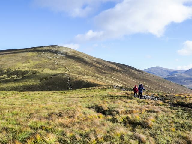
Corbett · Cairngorms
Meall a' Bhuachaille
Meall a' Bhuachaille — "hill of the shepherd" — is the friendly conical Corbett rising directly above Loch Morlich in Glenmore, the most accessible of all the Cairngorms-fringe summits. At 810m it gives one of the great close-up views of the main Cairngorm plateau across the Pass of Ryvoan, with the spread of Bynack More, Cairngorm and Braeriach on display. Its low elevation and excellent paths make it the busiest Corbett in the area — a hill rich in Highland history with the famous green lochan Lochan Uaine at its foot.
Quick facts
- Height
- 810m/ 2657ft
- Prominence
- 436 m
- Distance
- ~15 km
- Ascent
- ~713 m
- Time
- 4–7 hrs
- Grid ref
- NH990115
- Parking
- NH980097
- Nearest city
- Inverness· 47km
- Dogs
- Dogs on lead required near livestockDog-friendly guide ↗
Height and prominence cross-checked against the Database of British and Irish Hills (CC BY).
No GPX track yet
Walked this route? Share your track to help other walkers.
Standard route
pinewood path 35% · zigzag path 35% · heather dome 20% · summit cairn 10%
Start from the Glenmore Forest car park or the Pass of Ryvoan car park at Allt Mor. Follow the well-built path north through the Pass of Ryvoan past Lochan Uaine to Ryvoan bothy, then turn east up the engineered path that climbs steadily to the summit cairn. Return via the same line or descend the south path direct to Glenmore Lodge for a circuit. Around 15km return with 713m of ascent for the full Ryvoan circuit; 9km for the direct ascent.
Terrain
The Pass of Ryvoan path is well-built and easy underfoot through the pinewoods. The steeper ascent path is engineered with stone-pitched zig-zags and gives a clean route to the top. The summit is a broad heather-and-stone dome with a large cairn. No exposure or scrambling anywhere on the hill. Glenmore is a Forestry and Land Scotland area; expect bikes, runners and busy paths in summer.
In winter
One of the friendliest winter days in the Cairngorms-fringe — short approach, well-graded path, and one of the closest summit viewpoints of the snow-clad main plateau. The engineered path is followable under most snow conditions. The summit catches Cairngorm easterly drift; carry axe and crampons for the upper zig-zags after heavy snow. Glenmore Forest car parks are gritted and reliable.
Kit for this: the winter Munro kit list · which boots take crampons
This hill is in the Northern Cairngorms SAIS forecast area. Check SAIS forecasts in winter (December–April).
Best time of year
Getting there
- Glasgow3h 55m
- Edinburgh3h 59m
OS maps: OS Landranger 36
Mobile signal: Reasonable signal at Glenmore; usable on the summit
Current conditions
Daylight Today
- Sunrise
- 07:45
- Sunset
- 18:16
- Civil dawn
- 07:07
- Civil dusk
- 18:55
NOAA Solar Calculator · 14 October 2026
Pair with
Curated multi-hill combinations from Meall a' Bhuachaille.
Around Meall a' Bhuachaille on the SCOT network
Getting there, basing yourself, and what to do off the hill.
Getting there: Aviemore station
Cairngorm plateau; Lairig Ghru; Speyside Way; Glenmore
10km from the hill
tripscot.co.uk
On TripSCOTBase yourself in Aviemore
Cairngorms base — Strathspey valley, ski centre, train
10km from the hill
tripscot.co.uk
On TasteSCOTAfter the hill: Tomintoul
Tomintoul village — the gentle Speysider in the eastern Cairngorms
19km from the hill
tastescot.co.uk
Meall a' Bhuachaille — common questions
- What difficulty is Meall a' Bhuachaille?
- On the OutdoorSCOT scale, Meall a' Bhuachaille comes in at 3/5 — moderately challenging. Expect roughly 15km and 713m of ascent on the usual route — 4-7 hours for most parties. Terrain: The Pass of Ryvoan path is well-built and easy underfoot through the pinewoods.
- How prominent is Meall a' Bhuachaille?
- Meall a' Bhuachaille has 436m of topographic prominence — the height of its summit above the highest col connecting it to higher ground.
- Where should I park to climb Meall a' Bhuachaille?
- Standard parking is at NH980097. Check the parking grid reference on an OS map before travel; informal laybys can fill on summer weekends.
- When should I climb Meall a' Bhuachaille?
- The standard good-weather months for Meall a' Bhuachaille are April, May, June, July, August, September, October. Outside those months, expect winter conditions on the high ground — full mountain kit, navigation skills, and a check of the SAIS avalanche forecast for the relevant region.
- Can I bring my dog up Meall a' Bhuachaille?
- On a lead only — the route crosses ground with livestock or nesting-bird interest.
- What's mobile reception like on Meall a' Bhuachaille?
- Reasonable signal at Glenmore; usable on the summit
- Is Meall a' Bhuachaille safe in winter?
- One of the friendliest winter days in the Cairngorms-fringe — short approach, well-graded path, and one of the closest summit viewpoints of the snow-clad main plateau. The engineered path is followable under most snow conditions. The summit catches Cairngorm easterly drift; carry axe and crampons for the upper zig-zags after heavy snow. Glenmore Forest car parks are gritted and reliable.
Get the OutdoorSCOT weekly
One email a week — new route, hill and bothy guides, seasonal conditions and the odd hard-won lesson. No spam, unsubscribe in one click.