Corbett · Cairngorms
Geal Charn
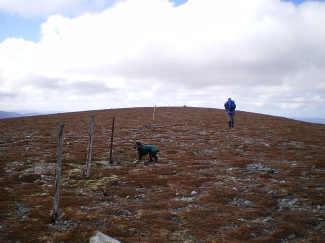
Geal-Charn — 'the white cairn' — is the 820m Corbett of the eastern Monadhliath, rising above Glen Banchor north-west of Newtonmore. The mountain is one of four Geal-Charns scattered across the Highlands, three of which are Munros; this one is the lowest, often left to the last by completers. The summit is a broad pale-quartzite plateau (the source of the name) with views east to the Cairngorm massif across the Spey valley and west into the rolling moorland heart of the Monadhliath.
Gaelic: “white, cairn-topped hill” · Pronunciation: gyal charn
Quick facts
- Height
- 820.6m/ 2692ft
- Prominence
- 173 m
- Distance
- 12 km
- Ascent
- 600 m
- Time
- 3–5 hrs
- Grid ref
- NJ090126
- Parking
- NN694997
- Nearest city
- Inverness· 53km
- Dogs
- Dogs on lead required near livestockDog-friendly guide ↗
Height and prominence cross-checked against the Database of British and Irish Hills (CC BY).
No GPX track yet
Walked this route? Share your track to help other walkers.
Standard route
estate track 25% · bog and heather 45% · plateau grass 20% · summit area 10%
Park at Glenballoch near Newtonmore (NN694997), the road end up Glen Banchor. Walk north-west on the estate track for around 3km along the River Calder, then climb north onto Geal-Charn's broad south-east ridge. The route gains the summit plateau gradually through heather and short grass. Often combined with Carn Dearg (the Monadhliath Munro) to the north for a long ridge day. Allow 5–6 hours for Geal-Charn alone.
Terrain
Excellent estate track on the approach. Beyond it, short heather and grass on the broad ridge — drier underfoot than the western Highlands. The summit plateau is open and featureless with a small cairn on a quartzite outcrop. Navigation in cloud needs care because the plateau has subtle subsidiary tops.
In winter
A friendly Monadhliath winter Corbett — broad slopes give no avalanche concerns, and snow lies well on the plateau through January and February. The Glen Banchor road is single-track and can be slow when iced. Cornice forms modestly on the north-east lip of the plateau; the broad summit is exposed to easterly winds.
This hill is in the Northern Cairngorms SAIS forecast area. Check SAIS forecasts in winter (December–April).
Best time of year
Getting there
- Glasgow3h 59m
- Edinburgh3h 58m
OS maps: OS Landranger 36, OS Explorer 403
Mobile signal: EE/Vodafone usable in Newtonmore and on the lower Glen Banchor road; weakens up the glen; intermittent on the summit
Current conditions
Daylight Today
- Sunrise
- 04:44
- Sunset
- 21:57
- Civil dawn
- 03:44
- Civil dusk
- 22:56
NOAA Solar Calculator · 17 July 2026
Around Geal Charn on the SCOT network
Getting there, basing yourself, and what to do off the hill.
Getting there: Aviemore station
Cairngorm plateau; Lairig Ghru; Speyside Way; Glenmore
19km from the hill
tripscot.co.uk
On TripSCOTBase yourself in Aviemore
Cairngorms base — Strathspey valley, ski centre, train
19km from the hill
tripscot.co.uk
On TasteSCOTAfter the hill: Tomintoul
Tomintoul village — the gentle Speysider in the eastern Cairngorms
9km from the hill
tastescot.co.uk
Geal Charn — common questions
- What difficulty is Geal Charn?
- On the OutdoorSCOT scale, Geal Charn comes in at 2/5 — moderate. Expect roughly 12km and 600m of ascent on the usual route — 3-5 hours for most parties. Terrain: Excellent estate track on the approach.
- How prominent is Geal Charn?
- Geal Charn has 173m of topographic prominence — the height of its summit above the highest col connecting it to higher ground.
- Where should I park to climb Geal Charn?
- Standard parking is at NN694997. Check the parking grid reference on an OS map before travel; informal laybys can fill on summer weekends.
- When should I climb Geal Charn?
- The standard good-weather months for Geal Charn are April, May, June, July, August, September, October. Outside those months, expect winter conditions on the high ground — full mountain kit, navigation skills, and a check of the SAIS avalanche forecast for the relevant region.
- Can I bring my dog up Geal Charn?
- On a lead only — the route crosses ground with livestock or nesting-bird interest.
- What's mobile reception like on Geal Charn?
- EE/Vodafone usable in Newtonmore and on the lower Glen Banchor road; weakens up the glen; intermittent on the summit
- Is Geal Charn safe in winter?
- A friendly Monadhliath winter Corbett — broad slopes give no avalanche concerns, and snow lies well on the plateau through January and February. The Glen Banchor road is single-track and can be slow when iced. Cornice forms modestly on the north-east lip of the plateau; the broad summit is exposed to easterly winds.
Get the OutdoorSCOT weekly
One email a week — new route, hill and bothy guides, seasonal conditions and the odd hard-won lesson. No spam, unsubscribe in one click.