Corbett · Cairngorms
Brown Cow Hill
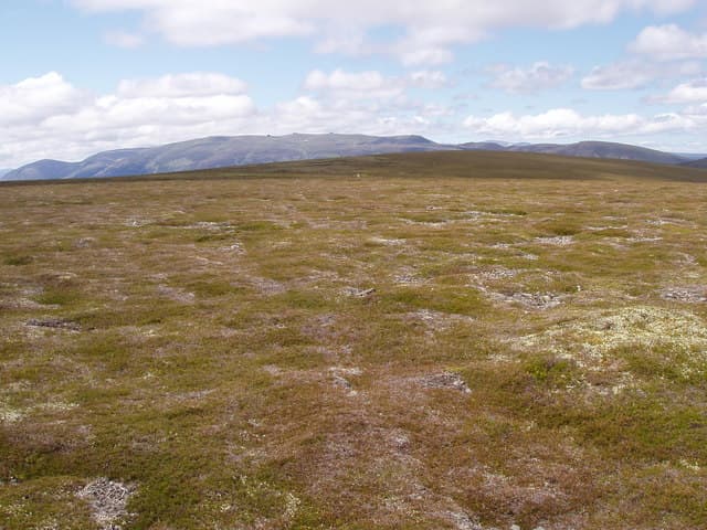
Brown Cow Hill is the rolling moorland Corbett at the north-eastern edge of the Cairngorms massif, set between Strathdon and the Lecht ski area. Its name does the hill no favours; the modest profile and unromantic title leave it among the least-visited Corbetts in eastern Scotland. But the 829m summit gives a fine open view across the Cromdale hills to Speyside and east to Lochnagar, and the heather walking on the broad north-east ridge is unusually dry and pleasant by Highland standards. A good early-season fitness hill from a Tomintoul or Strathdon base.
Quick facts
- Height
- 829m/ 2720ft
- Prominence
- 295 m
- Distance
- 11 km
- Ascent
- 460 m
- Time
- 2–4 hrs
- Grid ref
- NJ221044
- Parking
- NJ257093
- Nearest city
- Inverness· 69km
- Dogs
- Dogs on lead required near livestockDog-friendly guide ↗
Height and prominence cross-checked against the Database of British and Irish Hills (CC BY).
No GPX track yet
Walked this route? Share your track to help other walkers.
Standard route
moorland track 30% · heather moorland 45% · grassy upper slopes 15% · summit area 10%
Park at the Cock Bridge end of the A939 (NJ257093), the road known as 'the most dangerous in Britain' for its winter closures. A clear footpath heads south-west across open moorland, gaining height steadily onto the broad north-east ridge of Brown Cow Hill. The route reaches the summit cairn after around 5km. Descent reverses the line. Allow 4.5–5.5 hours.
Terrain
Heather and short grass throughout — drier than average for an eastern Cairngorms hill. The path is clear in good visibility but vague in places where the moor opens out. The summit plateau is broad and crowned by a small cairn; the descent line is hard to see in cloud because of the open featureless plateau.
In winter
The A939 over the Lecht regularly closes in winter — check the road status before driving up. When open, Brown Cow Hill makes a friendly winter day with no avalanche issues and snow lying reliably through January and February. Cold east winds from the Mearns are brutal on the broad summit; layer up.
This hill is in the Northern Cairngorms SAIS forecast area. Check SAIS forecasts in winter (December–April).
Best time of year
Getting there
- Glasgow3h 56m
- Edinburgh3h 46m
OS maps: OS Landranger 36
Mobile signal: Reasonable signal on this accessible Deeside hill — 2 bars at the top
Current conditions
Daylight Today
- Sunrise
- 04:37
- Sunset
- 22:01
- Civil dawn
- 03:35
- Civil dusk
- 23:02
NOAA Solar Calculator · 13 July 2026
Pair with
Curated multi-hill combinations from Brown Cow Hill.
Around Brown Cow Hill on the SCOT network
Getting there, basing yourself, and what to do off the hill.
Getting there: Aviemore station
Cairngorm plateau; Lairig Ghru; Speyside Way; Glenmore
34km from the hill
tripscot.co.uk
On TripSCOTBase yourself in Ballater
Eastern Cairngorms / Royal Deeside
17km from the hill
tripscot.co.uk
On TasteSCOTAfter the hill: Tomintoul
Tomintoul village — the gentle Speysider in the eastern Cairngorms
15km from the hill
tastescot.co.uk
Brown Cow Hill — common questions
- What difficulty is Brown Cow Hill?
- On the OutdoorSCOT scale, Brown Cow Hill comes in at 1/5 — easy. Expect roughly 11km and 460m of ascent on the usual route — 2-4 hours for most parties. Underfoot: Heather and short grass throughout — drier than average for an eastern Cairngorms hill.
- What is Brown Cow Hill's prominence?
- 295m of prominence. That's the vertical drop from the summit to the col that links Brown Cow Hill to the next higher ground.
- Where do I park for Brown Cow Hill?
- Most walkers start from NJ257093. Verify the grid reference on an OS map before you set off — space is tight on busy summer weekends.
- When is the best time to climb Brown Cow Hill?
- April, May, June, July, August, September, October give the most reliable conditions on Brown Cow Hill. Beyond that window the high ground turns wintry: carry full mountain kit, be confident navigating, and check the SAIS avalanche forecast for the area.
- Is Brown Cow Hill dog-friendly?
- Yes, but dogs must be kept on a lead — there is livestock or ground-nesting bird interest on the route.
- Is there mobile signal on Brown Cow Hill?
- Reasonable signal on this accessible Deeside hill — 2 bars at the top
- Is Brown Cow Hill safe in winter?
- The A939 over the Lecht regularly closes in winter — check the road status before driving up. When open, Brown Cow Hill makes a friendly winter day with no avalanche issues and snow lying reliably through January and February. Cold east winds from the Mearns are brutal on the broad summit; layer up.
Get the OutdoorSCOT weekly
One email a week — new route, hill and bothy guides, seasonal conditions and the odd hard-won lesson. No spam, unsubscribe in one click.