Graham · Cairngorms
Mona Gowan
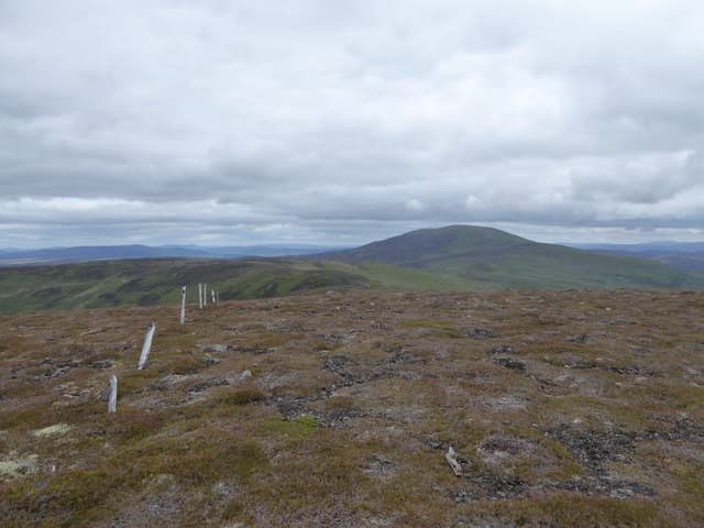
A heathery dome topped by a huge stone-built cairn high above Glen Gairn between Ballater and Strathdon, with extensive views east to the Aberdeenshire farmland and west to the Cairngorm plateau. The cairn is one of the largest summit markers in north-east Scotland.
Quick facts
- Height
- 749m/ 2457ft
- Prominence
- 194 m
- Distance
- 14 km
- Ascent
- 614 m
- Time
- 4–7 hrs
- Grid ref
- NJ335058
- Parking
- NJ372001
- Nearest city
- Aberdeen· 61km
- Dogs
- Dogs on lead required near livestockDog-friendly guide ↗
Height and prominence cross-checked against the Database of British and Irish Hills (CC BY).
No GPX track yet
Walked this route? Share your track to help other walkers.
Standard route
estate track 35% · heather moorland 45% · grassy plateau 10% · summit area 10%
From the bridge at Bridgend on the B976 follow the estate road and grouse tracks west up Glen Fenzie, climbing steadily onto the open moor. A final short section over deep heather reaches the cairn.
Terrain
Almost the entire route is on grouse-moor tracks, with only a short pathless section near the summit through managed heather and bilberry.
In winter
A typical eastern Cairngorms summit where the dry continental winter brings frost-hardened heather and patchy windslab on the lee side. Avalanche risk minimal at this altitude but the open moor is fully exposed to wind chill.
This hill is in the Northern Cairngorms SAIS forecast area. Check SAIS forecasts in winter (December–April).
Best time of year
Getting there
- Glasgow3h 3m
- Edinburgh3h 49m
OS maps: OS Landranger 37
Mobile signal: Reasonable signal near Tomnavoulin; 2 bars on the summit
Current conditions
Daylight Today
- Sunrise
- 04:42
- Sunset
- 21:55
- Civil dawn
- 03:43
- Civil dusk
- 22:54
NOAA Solar Calculator · 17 July 2026
Pair with
Curated multi-hill combinations from Mona Gowan.
Around Mona Gowan on the SCOT network
Getting there, basing yourself, and what to do off the hill.
Getting there: Aviemore station
Cairngorm plateau; Lairig Ghru; Speyside Way; Glenmore
44km from the hill
tripscot.co.uk
On TripSCOTBase yourself in Ballater
Eastern Cairngorms / Royal Deeside
11km from the hill
tripscot.co.uk
On TasteSCOTAfter the hill: Royal Lochnagar
Balmoral — Queen Victoria's favourite; eastern Cairngorms setting
17km from the hill
tastescot.co.uk
Mona Gowan — common questions
- How difficult is Mona Gowan?
- Mona Gowan carries a 4/5 (challenging) grade on the OutdoorSCOT scale. Count on about 14km, 614m of ascent and a 4-7 hour day on the standard route. Ground conditions: Almost the entire route is on grouse-moor tracks, with only a short pathless section near the summit through managed heather and bilberry.
- How much drop does Mona Gowan have?
- The drop is 194m: measured from the summit of Mona Gowan down to the saddle joining it to higher terrain.
- Where's the parking for Mona Gowan?
- Park at NJ372001. Double-check the grid reference on an OS map first; informal laybys here fill early in high season.
- What's the best month to climb Mona Gowan?
- Aim for April, May, June, July, August, September, October on Mona Gowan. In the remaining months treat it as a winter hill — full kit, solid navigation, and a look at the relevant SAIS avalanche forecast before you go.
- Can dogs go up Mona Gowan?
- Dogs are fine on a lead. The route passes livestock or ground-nesting bird habitat, so keep them close throughout.
- Will I get phone signal on Mona Gowan?
- Reasonable signal near Tomnavoulin; 2 bars on the summit
- Is Mona Gowan safe in winter?
- A typical eastern Cairngorms summit where the dry continental winter brings frost-hardened heather and patchy windslab on the lee side. Avalanche risk minimal at this altitude but the open moor is fully exposed to wind chill.
Get the OutdoorSCOT weekly
One email a week — new route, hill and bothy guides, seasonal conditions and the odd hard-won lesson. No spam, unsubscribe in one click.