Graham · Cairngorms
Ladylea Hill
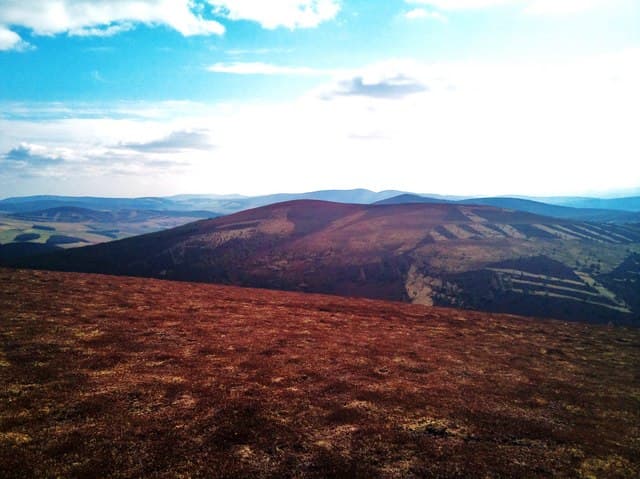
Ladylea Hill (609m) sits between Glenbuchat and Strathdon in the NJ31 square, an east-Cairngorm outlier on the upper Don. The cairn is set into open heather ground, with a far view from Bennachie's tors to the high Cairngorms and out east toward the Moray coast. The hill is a popular day trip from Donside, with hill tracks built for the grouse season giving most of the height-gain on firm ground.
Quick facts
- Height
- 609.1m/ 1998ft
- Prominence
- 201 m
- Distance
- 12 km
- Ascent
- 457 m
- Time
- 3–5 hrs
- Grid ref
- NJ343168
- Parking
- NJ336173
- Nearest city
- Aberdeen· 61km
- Dogs
- Dogs on lead required near livestockDog-friendly guide ↗
Height and prominence cross-checked against the Database of British and Irish Hills (CC BY).
No GPX track yet
Walked this route? Share your track to help other walkers.
Standard route
grass moorland 80% · heather patches 15% · summit area 5%
From the layby at NJ336173 on the Glenbuchat road, take the estate track climbing east onto the broad heather flank. The track winds up to nearly summit height; the final stretch is a few hundred metres on heather to the cairn. About three hours round trip. The track makes the route straightforward to retrace in any weather.
Terrain
Estate hill track for the lower and middle reaches, with managed heather and a scatter of granite boulders higher up. The summit cairn sits on a level patch of heather with a few stones broken out around its base. Burns drain steeply north toward the Don.
In winter
Strathdon and Glenbuchat catch east-coast cold and Ladylea Hill's open heather drifts thickly in lee hollows. The hill track is the safest descent line in poor weather. Wind chill on the bare summit is the main concern — short visits in settled cold are rewarding for the clarity of the light.
This hill is in the Northern Cairngorms SAIS forecast area. Check SAIS forecasts in winter (December–April).
Best time of year
Getting there
- Glasgow3h 15m
- Edinburgh3h 2m
OS maps: OS Landranger 37
Mobile signal: Signal is good; EE reliable with views to the Moray coast.
Current conditions
Daylight Today
- Sunrise
- 04:35
- Sunset
- 22:01
- Civil dawn
- 03:33
- Civil dusk
- 23:03
NOAA Solar Calculator · 13 July 2026
Around Ladylea Hill on the SCOT network
Getting there, basing yourself, and what to do off the hill.
Getting there: Aviemore station
Cairngorm plateau; Lairig Ghru; Speyside Way; Glenmore
45km from the hill
tripscot.co.uk
On TripSCOTBase yourself in Ballater
Eastern Cairngorms / Royal Deeside
21km from the hill
tripscot.co.uk
On TasteSCOTAfter the hill: The Glenlivet
Ballindalloch — the first legal distillery under the 1823 Excise Act
13km from the hill
tastescot.co.uk
Ladylea Hill — common questions
- How difficult is Ladylea Hill?
- Ladylea Hill carries a 3/5 (moderately challenging) grade on the OutdoorSCOT scale. Count on about 12km, 457m of ascent and a 3-5 hour day on the standard route. Terrain: Estate hill track for the lower and middle reaches, with managed heather and a scatter of granite boulders higher up.
- How prominent is Ladylea Hill?
- Ladylea Hill has 201m of topographic prominence — the height of its summit above the highest col connecting it to higher ground.
- Where should I park to climb Ladylea Hill?
- Standard parking is at NJ336173. Check the parking grid reference on an OS map before travel; informal laybys can fill on summer weekends.
- When should I climb Ladylea Hill?
- The standard good-weather months for Ladylea Hill are March, April, May, June, July, August, September, October, November. Outside those months, expect winter conditions on the high ground — full mountain kit, navigation skills, and a check of the SAIS avalanche forecast for the relevant region.
- Can I bring my dog up Ladylea Hill?
- On a lead only — the route crosses ground with livestock or nesting-bird interest.
- What's mobile reception like on Ladylea Hill?
- Signal is good; EE reliable with views to the Moray coast.
- Is Ladylea Hill safe in winter?
- Strathdon and Glenbuchat catch east-coast cold and Ladylea Hill's open heather drifts thickly in lee hollows. The hill track is the safest descent line in poor weather. Wind chill on the bare summit is the main concern — short visits in settled cold are rewarding for the clarity of the light.
Get the OutdoorSCOT weekly
One email a week — new route, hill and bothy guides, seasonal conditions and the odd hard-won lesson. No spam, unsubscribe in one click.