Munro · Cairngorms
Beinn a' Chaorainn
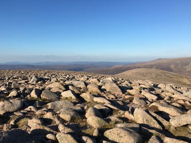
This Beinn a' Chaorainn — "hill of the rowan tree" — is the 1083m eastern-Cairngorm Munro between Glen Derry and Glen Avon, north of Derry Cairngorm. The summit is a large cairn on a broad granite plateau with views west into the heart of the main Cairngorm massif and east across the wide Geldie watershed. Often paired with Beinn Bhreac across the broad bealach to the south for a two-Munro Glen Derry round.
Quick facts
- Height
- 1083.3m/ 3554ft
- Prominence
- 246 m
- Distance
- ~29 km
- Ascent
- ~860 m
- Time
- 6–9 hrs
- Grid ref
- NJ045013
- Parking
- NO062898
- Nearest city
- Inverness· 58km
- Dogs
- Dogs on lead required near livestockDog-friendly guide ↗
Height and prominence cross-checked against the Database of British and Irish Hills (CC BY).
No GPX track yet
Walked this route? Share your track to help other walkers.
Standard route
Estate track / forest path 30% · Open hillside 40% · Summit plateau 30%
From the Linn of Dee, follow Glen Lui through to Derry Lodge then continue north up Glen Derry on the long stalkers path. Climb the broad south ridge of Beinn a' Chaorainn to the summit plateau. Around 29km return with some 860m of ascent; ride the lower 8km of estate track for efficiency. Most parties combine with Beinn Bhreac.
Terrain
The Glen Lui and Glen Derry tracks are firm gravel through ancient Caledonian pinewoods — bike-friendly to Derry Lodge. The climb onto the broad south ridge is on rough heather; the summit plateau is granite gravel and short moss. No exposure on the standard line; navigation across the wide plateau in mist is the main challenge.
In winter
A long winter day in Cairngorms-arctic conditions. The plateau is featureless under snow; whiteout navigation demands competence. Cornicing on the north sides into Glen Avon. The Linn of Dee road is gritted; the Glen Lui track ices in cold snaps. SAIS Northern Cairngorms applies.
Kit for this: the winter Munro kit list · which boots take crampons
This hill is in the Northern Cairngorms SAIS forecast area. Check SAIS forecasts in winter (December–April).
Best time of year
Getting there
- Glasgow3h 3m
- Edinburgh3h 45m
OS maps: OS Landranger 36
Mobile signal: Signal gone above 800m. Linn of Dee has occasional coverage. Download Harvey Cairngorms map before the drive.
Current conditions
Daylight Today
- Sunrise
- 08:02
- Sunset
- 17:56
- Civil dawn
- 07:23
- Civil dusk
- 18:35
NOAA Solar Calculator · 22 October 2026
Around Beinn a' Chaorainn on the SCOT network
Getting there, basing yourself, and what to do off the hill.
Getting there: Aviemore station
Cairngorm plateau; Lairig Ghru; Speyside Way; Glenmore
19km from the hill
tripscot.co.uk
On TripSCOTBase yourself in Aviemore
Cairngorms base — Strathspey valley, ski centre, train
19km from the hill
tripscot.co.uk
On TasteSCOTAfter the hill: Tomintoul
Tomintoul village — the gentle Speysider in the eastern Cairngorms
21km from the hill
tastescot.co.uk
Beinn a' Chaorainn — common questions
- What difficulty is Beinn a' Chaorainn?
- On the OutdoorSCOT scale, Beinn a' Chaorainn comes in at 3/5 — moderately challenging. Expect roughly 29km and 860m of ascent on the usual route — 6-9 hours for most parties. Ground conditions: The Glen Lui and Glen Derry tracks are firm gravel through ancient Caledonian pinewoods — bike-friendly to Derry Lodge.
- How much drop does Beinn a' Chaorainn have?
- The drop is 246m: measured from the summit of Beinn a' Chaorainn down to the saddle joining it to higher terrain.
- Where's the parking for Beinn a' Chaorainn?
- Park at NO062898. Double-check the grid reference on an OS map first; informal laybys here fill early in high season.
- What's the best month to climb Beinn a' Chaorainn?
- Aim for May, June, July, August, September, October on Beinn a' Chaorainn. In the remaining months treat it as a winter hill — full kit, solid navigation, and a look at the relevant SAIS avalanche forecast before you go.
- Can dogs go up Beinn a' Chaorainn?
- Dogs are fine on a lead. The route passes livestock or ground-nesting bird habitat, so keep them close throughout.
- Will I get phone signal on Beinn a' Chaorainn?
- Signal gone above 800m. Linn of Dee has occasional coverage. Download Harvey Cairngorms map before the drive.
- Is Beinn a' Chaorainn safe in winter?
- A long winter day in Cairngorms-arctic conditions. The plateau is featureless under snow; whiteout navigation demands competence. Cornicing on the north sides into Glen Avon. The Linn of Dee road is gritted; the Glen Lui track ices in cold snaps. SAIS Northern Cairngorms applies.
Get the OutdoorSCOT weekly
One email a week — new route, hill and bothy guides, seasonal conditions and the odd hard-won lesson. No spam, unsubscribe in one click.