Munro · Cairngorms
Cairn Toul
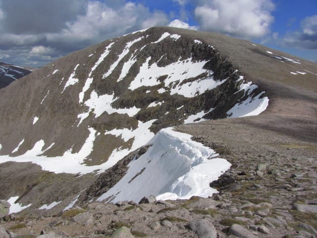
Cairn Toul is the fourth-highest Munro at 1291m, the southern peak of the great Braeriach–Cairn Toul horseshoe that flanks the western side of the Lairig Ghru. Where Braeriach sprawls, Cairn Toul rises in a single shapely cone — the most distinctive profile in the Cairngorms when seen from Glen Lui. The summit is a large cairn directly above the cliffs of Coire an Lochain Uaine; views east across the Lairig Ghru to Ben Macdui and south down the Dee to Lochnagar are among the finest in the range.
Quick facts
- Height
- 1291m/ 4236ft
- Prominence
- 166 m
- Distance
- 20 km
- Ascent
- 1136 m
- Time
- 7–10 hrs
- Grid ref
- NN963972
- Parking
- NO062898
- Nearest city
- Inverness· 56km
- Dogs
- Dogs on lead required near livestockDog-friendly guide ↗
Height and prominence cross-checked against the Database of British and Irish Hills (CC BY).
No GPX track yet
Walked this route? Share your track to help other walkers.
Standard route
Glen / stalkers path 40% · Mountain path 30% · Plateau / boulder field 30%
Almost always climbed as part of the classic Braeriach horseshoe from Whitewell or Coylumbridge — around 28km and 1700m of ascent for the full round over four Munros including Sgor an Lochain Uaine. The short individual line is the long approach from Linn of Dee up Glen Luibeg to White Bridge, then north up the Lairig Ghru and into Coire an t-Saighdeir for the summit. Around 20km and 1136m for Cairn Toul alone via this southern route.
Terrain
The Lairig Ghru path is firm gravel, the Glen Luibeg track wide and well-drained. The ascent into Coire an t-Saighdeir is rough boulder-and-scree ground, slow underfoot. The summit ridge runs along a corrie rim that is undercut by perennial snow patches and cornices into July. The plateau is true arctic-alpine terrain — sparse moss-campion turf with broken granite blocks.
In winter
A major winter mountain. The Coire an Lochain Uaine cliffs hold Grade III–V climbs that draw climbers from across Europe. Cornices form continuously along the summit ridge after westerly storms and collapse onto the corrie floor. The Lairig Ghru fills with deep wind-blown snow that can mask the path entirely. Navigation across the plateau in whiteout is the principal risk; carry compass, GPS and head-torch as standard.
This hill is in the Northern Cairngorms SAIS forecast area. Check SAIS forecasts in winter (December–April).
Best time of year
Getting there
- Glasgow3h 55m
- Edinburgh3h 42m
OS maps: OS Landranger 36, OS Landranger 43
Mobile signal: Signal-free from start to summit. The nearest reliable signal is at the Linn of Dee car park (limited). Keep navigation tools independent of mobile data.
Current conditions
Daylight Today
- Sunrise
- 04:56
- Sunset
- 21:47
- Civil dawn
- 04:00
- Civil dusk
- 22:43
NOAA Solar Calculator · 23 July 2026
Pair with
Curated multi-hill combinations from Cairn Toul.
Around Cairn Toul on the SCOT network
Getting there, basing yourself, and what to do off the hill.
Getting there: Aviemore station
Cairngorm plateau; Lairig Ghru; Speyside Way; Glenmore
17km from the hill
tripscot.co.uk
On TripSCOTBase yourself in Aviemore
Cairngorms base — Strathspey valley, ski centre, train
17km from the hill
tripscot.co.uk
On TasteSCOTAfter the hill: Tomintoul
Tomintoul village — the gentle Speysider in the eastern Cairngorms
29km from the hill
tastescot.co.uk
Cairn Toul — common questions
- How difficult is Cairn Toul?
- Cairn Toul carries a 4/5 (challenging) grade on the OutdoorSCOT scale. Count on about 20km, 1136m of ascent and a 7-10 hour day on the standard route. Ground conditions: The Lairig Ghru path is firm gravel, the Glen Luibeg track wide and well-drained.
- How much drop does Cairn Toul have?
- The drop is 166m: measured from the summit of Cairn Toul down to the saddle joining it to higher terrain.
- Where's the parking for Cairn Toul?
- Park at NO062898. Double-check the grid reference on an OS map first; informal laybys here fill early in high season.
- What's the best month to climb Cairn Toul?
- Aim for May, June, July, August, September, October on Cairn Toul. In the remaining months treat it as a winter hill — full kit, solid navigation, and a look at the relevant SAIS avalanche forecast before you go.
- Can dogs go up Cairn Toul?
- Dogs are fine on a lead. The route passes livestock or ground-nesting bird habitat, so keep them close throughout.
- Will I get phone signal on Cairn Toul?
- Signal-free from start to summit. The nearest reliable signal is at the Linn of Dee car park (limited). Keep navigation tools independent of mobile data.
- Is Cairn Toul safe in winter?
- A major winter mountain. The Coire an Lochain Uaine cliffs hold Grade III–V climbs that draw climbers from across Europe. Cornices form continuously along the summit ridge after westerly storms and collapse onto the corrie floor. The Lairig Ghru fills with deep wind-blown snow that can mask the path entirely. Navigation across the plateau in whiteout is the principal risk; carry compass, GPS and head-torch as standard.
Get the OutdoorSCOT weekly
One email a week — new route, hill and bothy guides, seasonal conditions and the odd hard-won lesson. No spam, unsubscribe in one click.