Munro · Cairngorms
Sgor Gaoith
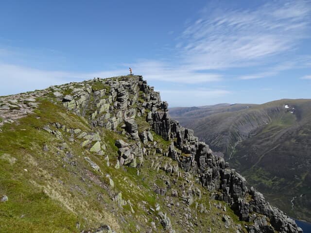
Sgor Gaoith — "peak of the wind" — is the 1116m Munro on the western edge of the Cairngorm plateau, with one of the most spectacular summit positions in Britain: a narrow rocky knoll directly above the 600m drop into Loch Einich. The view down to the loch is a defining Cairngorm spectacle. The hill forms part of the long Moine Mhor plateau that runs south from Cairn Toul, and the summit cairn sits on the very lip of the corrie edge — unmistakable when the visibility allows.
Quick facts
- Height
- 1116m/ 3661ft
- Prominence
- 243 m
- Distance
- 18 km
- Ascent
- 982 m
- Time
- 6–9 hrs
- Grid ref
- NN903989
- Parking
- NN852976
- Nearest city
- Inverness· 52km
- Dogs
- Dogs on lead required near livestockDog-friendly guide ↗
Height and prominence cross-checked against the Database of British and Irish Hills (CC BY).
No GPX track yet
Walked this route? Share your track to help other walkers.
Standard route
Forestry track / glen track 40% · Open hillside 30% · Plateau edge / summit ridge 30%
The standard line is from Achlean in Glen Feshie. Climb the path north-east through pinewoods onto the broad Moine Mhor plateau, then follow the plateau north to the corrie rim and the summit. Around 18km return with 982m of ascent. Strong walkers extend over Mullach Clach a' Bhlair to the south or onto the wider Cairngorm plateau for longer days.
Terrain
The Achlean path is firm through the pinewoods and onto the open hill. The Moine Mhor plateau is short heather and granite gravel — featureless on a misty day, glorious in clear weather. The corrie rim has multiple cliff lines undercut by snow patches; stay well back. The summit cairn is on the very edge of the cliff above Loch Einich.
In winter
A spectacular but dangerous winter Munro. The corrie rim is corniced continuously through the season and has been the site of fatal accidents. The Moine Mhor plateau is featureless under snow and a serious navigation challenge in whiteout. Cornices reach 5–10m horizontally over the cliff edge in heavy years. SAIS Northern Cairngorms applies.
This hill is in the Northern Cairngorms SAIS forecast area. Check SAIS forecasts in winter (December–April).
Best time of year
Getting there
- Glasgow3h 55m
- Edinburgh3h 46m
OS maps: OS Landranger 36, OS Landranger 43
Mobile signal: No signal on the plateau above Loch Einich. Feshiebridge or Achlean has occasional signal. The Gleann Einich approach is fully remote — download maps before leaving Kingussie.
Current conditions
Daylight Today
- Sunrise
- 04:56
- Sunset
- 21:47
- Civil dawn
- 04:00
- Civil dusk
- 22:43
NOAA Solar Calculator · 23 July 2026
Pair with
Curated multi-hill combinations from Sgor Gaoith.
Around Sgor Gaoith on the SCOT network
Getting there, basing yourself, and what to do off the hill.
Sgor Gaoith — common questions
- What difficulty is Sgor Gaoith?
- On the OutdoorSCOT scale, Sgor Gaoith comes in at 4/5 — challenging. Expect roughly 18km and 982m of ascent on the usual route — 6-9 hours for most parties. Underfoot: The Achlean path is firm through the pinewoods and onto the open hill.
- What is Sgor Gaoith's prominence?
- 243m of prominence. That's the vertical drop from the summit to the col that links Sgor Gaoith to the next higher ground.
- Where do I park for Sgor Gaoith?
- Most walkers start from NN852976. Verify the grid reference on an OS map before you set off — space is tight on busy summer weekends.
- When is the best time to climb Sgor Gaoith?
- May, June, July, August, September, October give the most reliable conditions on Sgor Gaoith. Beyond that window the high ground turns wintry: carry full mountain kit, be confident navigating, and check the SAIS avalanche forecast for the area.
- Is Sgor Gaoith dog-friendly?
- Yes, but dogs must be kept on a lead — there is livestock or ground-nesting bird interest on the route.
- Is there mobile signal on Sgor Gaoith?
- No signal on the plateau above Loch Einich. Feshiebridge or Achlean has occasional signal. The Gleann Einich approach is fully remote — download maps before leaving Kingussie.
- Is Sgor Gaoith safe in winter?
- A spectacular but dangerous winter Munro. The corrie rim is corniced continuously through the season and has been the site of fatal accidents. The Moine Mhor plateau is featureless under snow and a serious navigation challenge in whiteout. Cornices reach 5–10m horizontally over the cliff edge in heavy years. SAIS Northern Cairngorms applies.
Get the OutdoorSCOT weekly
One email a week — new route, hill and bothy guides, seasonal conditions and the odd hard-won lesson. No spam, unsubscribe in one click.