Graham · Central Highlands
Creag Dhubh
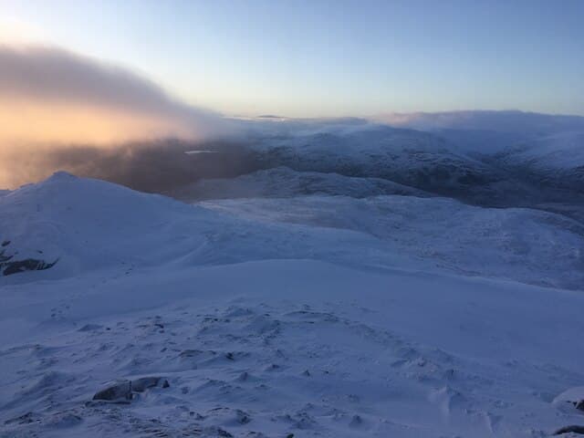
A craggy ridge rising directly above the A86 west of Newtonmore, famous as the rallying-cry hill of Clan Macpherson and adorned with broken crag faces well known to rock climbers. The compact summit ridge gives a stunning ground-level view across the upper Spey to the Cairngorms.
Gaelic: “crag, black” · Pronunciation: krayg goo
Quick facts
- Height
- 752.9m/ 2470ft
- Prominence
- 388 m
- Distance
- 14 km
- Ascent
- 617 m
- Time
- 4–7 hrs
- Grid ref
- NN677972
- Parking
- NN688957
- Nearest city
- Inverness· 48km
- Dogs
- Dogs on lead required near livestockDog-friendly guide ↗
Height and prominence cross-checked against the Database of British and Irish Hills (CC BY).
No GPX track yet
Walked this route? Share your track to help other walkers.
Standard route
moorland path 25% · heather hillside 45% · rocky upper slopes 20% · summit area 10%
Most parties park at the layby east of Lochan Ovie and tackle the steep crag-bordered south flank by zigzagging up rakes between buttresses, before a short walk along the ridge to the summit. A traverse east-to-west or west-to-east is the usual outing.
Terrain
Steep heather between rock bands on ascent — care needed picking a line. The ridge itself is short, grassy and easy. Some greasy slabs in wet weather.
In winter
Verglas on the rakes between the crag bands turns this into a serious mixed proposition. Sub-800m height means snow cover is intermittent and conditions change hour by hour as fronts sweep up the Spey.
This hill is in the Creag Meagaidh SAIS forecast area. Check SAIS forecasts in winter (December–April).
Best time of year
Getting there
- Glasgow3h 48m
- Edinburgh3h 54m
OS maps: OS Landranger 35, OS Explorer 401
Mobile signal: Intermittent signal near Newtonmore; brief coverage on the summit
Current conditions
Daylight Today
- Sunrise
- 04:47
- Sunset
- 21:58
- Civil dawn
- 03:48
- Civil dusk
- 22:57
NOAA Solar Calculator · 17 July 2026
Pair with
Curated multi-hill combinations from Creag Dhubh.
Around Creag Dhubh on the SCOT network
Getting there, basing yourself, and what to do off the hill.
Getting there: Kingussie station
Cairngorms south side; Glen Feshie; Insh Marshes; Monadhliath access
9km from the hill
tripscot.co.uk
On TripSCOTBase yourself in Aviemore
Cairngorms base — Strathspey valley, ski centre, train
27km from the hill
tripscot.co.uk
On TasteSCOTAfter the hill: Dalwhinnie
Dalwhinnie — Scotland's highest distillery on the Drumochter pass
13km from the hill
tastescot.co.uk
Creag Dhubh — common questions
- How hard is Creag Dhubh?
- We grade Creag Dhubh at 4/5, which puts it in challenging territory. The usual route is around 14km with 617m of climbing; allow 4-7 hours. Underfoot: Steep heather between rock bands on ascent — care needed picking a line.
- What is Creag Dhubh's prominence?
- 388m of prominence. That's the vertical drop from the summit to the col that links Creag Dhubh to the next higher ground.
- Where do I park for Creag Dhubh?
- Most walkers start from NN688957. Verify the grid reference on an OS map before you set off — space is tight on busy summer weekends.
- When is the best time to climb Creag Dhubh?
- April, May, June, July, August, September, October give the most reliable conditions on Creag Dhubh. Beyond that window the high ground turns wintry: carry full mountain kit, be confident navigating, and check the SAIS avalanche forecast for the area.
- Is Creag Dhubh dog-friendly?
- Yes, but dogs must be kept on a lead — there is livestock or ground-nesting bird interest on the route.
- Is there mobile signal on Creag Dhubh?
- Intermittent signal near Newtonmore; brief coverage on the summit
- Is Creag Dhubh safe in winter?
- Verglas on the rakes between the crag bands turns this into a serious mixed proposition. Sub-800m height means snow cover is intermittent and conditions change hour by hour as fronts sweep up the Spey.
Get the OutdoorSCOT weekly
One email a week — new route, hill and bothy guides, seasonal conditions and the odd hard-won lesson. No spam, unsubscribe in one click.