Graham · Central Highlands
Meall nan Eagan
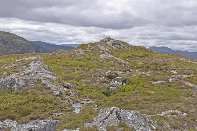
Meall nan Eagan (657m) — the hill of the notches — is a peaty Drumochter outlier in the NN58 square, looking down on the Spey at Catlodge. Its rocky summit offers an unusually wide arc of view from the Cairngorms across to Ben Alder and the Drumochter Munros.
Quick facts
- Height
- 657.9m/ 2158ft
- Prominence
- 166 m
- Distance
- 13 km
- Ascent
- 539 m
- Time
- 3–6 hrs
- Grid ref
- NN596874
- Parking
- NN588866
- Nearest
- Fort William· Inverness 58km
- Dogs
- Dogs on lead required near livestockDog-friendly guide ↗
Height and prominence cross-checked against the Database of British and Irish Hills (CC BY).
No GPX track yet
Walked this route? Share your track to help other walkers.
Standard route
heather moorland 60% · grass slopes 30% · rocky summit 10%
Park at Catlodge on the A889 between Newtonmore and Laggan. Take the estate track south past the cottages, then leave it on a quad rut climbing south-east onto the broad shoulder. The summit rock is the highest of several notched outcrops on the rolling crest — a short cross-country leg from the track high point.
Terrain
Estate track and quad ruts give an easy lead-in; off-piste the ground is firm heather with quartzite outcrops. The "notched" character of the summit means several knobs of similar height — confirm the true top by GPS in poor visibility.
In winter
Drumochter is famous for its drifting easterlies and Meall nan Eagan catches the full force. Wind-blown snow can hide the quartzite outcrops and make footing awkward; spikes are often more useful than crampons. The hill is reached easily by car so a short midwinter outing is feasible.
This hill is in the Creag Meagaidh SAIS forecast area. Check SAIS forecasts in winter (December–April).
Best time of year
Getting there
- Glasgow3h 36m
- Edinburgh3h 47m
OS maps: OS Landranger 42
Mobile signal: Moderate. EE reasonable on the A889 corridor; weaker on the summit dome.
Current conditions
Daylight Today
- Sunrise
- 04:42
- Sunset
- 22:04
- Civil dawn
- 03:41
- Civil dusk
- 23:05
NOAA Solar Calculator · 13 July 2026
Around Meall nan Eagan on the SCOT network
Getting there, basing yourself, and what to do off the hill.
Getting there: Dalwhinnie station
Highest mainline station; Drumochter Munros; Ben Alder approach
4km from the hill
tripscot.co.uk
On TripSCOTBase yourself in Aviemore
Cairngorms base — Strathspey valley, ski centre, train
39km from the hill
tripscot.co.uk
On TasteSCOTAfter the hill: Dalwhinnie
Dalwhinnie — Scotland's highest distillery on the Drumochter pass
4km from the hill
tastescot.co.uk
Meall nan Eagan — common questions
- What difficulty is Meall nan Eagan?
- On the OutdoorSCOT scale, Meall nan Eagan comes in at 3/5 — moderately challenging. Expect roughly 13km and 539m of ascent on the usual route — 3-6 hours for most parties. Ground conditions: Estate track and quad ruts give an easy lead-in; off-piste the ground is firm heather with quartzite outcrops.
- How much drop does Meall nan Eagan have?
- The drop is 166m: measured from the summit of Meall nan Eagan down to the saddle joining it to higher terrain.
- Where's the parking for Meall nan Eagan?
- Park at NN588866 near Fort William. Double-check the grid reference on an OS map first; informal laybys here fill early in high season.
- What's the best month to climb Meall nan Eagan?
- Aim for March, April, May, June, July, August, September, October, November on Meall nan Eagan. In the remaining months treat it as a winter hill — full kit, solid navigation, and a look at the relevant SAIS avalanche forecast before you go.
- Can dogs go up Meall nan Eagan?
- Dogs are fine on a lead. The route passes livestock or ground-nesting bird habitat, so keep them close throughout.
- Will I get phone signal on Meall nan Eagan?
- Moderate. EE reasonable on the A889 corridor; weaker on the summit dome.
- Is Meall nan Eagan safe in winter?
- Drumochter is famous for its drifting easterlies and Meall nan Eagan catches the full force. Wind-blown snow can hide the quartzite outcrops and make footing awkward; spikes are often more useful than crampons. The hill is reached easily by car so a short midwinter outing is feasible.
Get the OutdoorSCOT weekly
One email a week — new route, hill and bothy guides, seasonal conditions and the odd hard-won lesson. No spam, unsubscribe in one click.