Munro · Central Highlands
Geal Charn
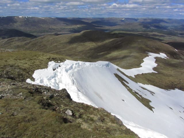
Geal Chàrn (1049m) — sometimes called Mullach Coire an Iubhair — is the highest of the three Ardverikie Munros north of Loch Laggan, with Beinn a' Chlachair to its west and Creag Pitridh to its east. Together the three are usually walked as a long but rewarding round from the dam at the western end of Loch Laggan. The summit is a broad mossy plateau crowned with a trig pillar and a large cairn, with views east along the length of Loch Laggan to the Monadhliath beyond.
Gaelic: “white, cairn-topped hill” · Pronunciation: gyal charn
Quick facts
- Height
- 1049.7m/ 3444ft
- Prominence
- 311 m
- Distance
- 18 km
- Ascent
- 924 m
- Time
- 6–9 hrs
- Grid ref
- NN504811
- Parking
- NN432833
- Nearest city
- Fort William· 40km
- Dogs
- Dogs on lead required near livestockDog-friendly guide ↗
Height and prominence cross-checked against the Database of British and Irish Hills (CC BY).
No GPX track yet
Walked this route? Share your track to help other walkers.
Standard route
Estate track 35% · Open hillside 35% · Summit plateau 30%
Park at the Lagan side of Spey Dam or use the small lay-by at the Pattack falls car park. Walk west along the private estate track past the Pattack power station and into the Ardverikie forest, then strike north up Coire na Saobhaidh onto Beinn a' Chlachair. From the summit traverse east along the broad ridge to the deep Bealach Leamhain, then climb the west ridge of Geal Chàrn. Add Creag Pitridh by dropping north-east. Around 24km with 1300m of ascent for the three Munros.
Terrain
The Ardverikie estate landrover tracks are firm landrover surface and run deep into the hills. Above the tracks the going is wet heather and short grass with little path. The Beinn a' Chlachair north corrie rim has impressive crags and the summit plateau is a confusing area in mist. The Bealach Leamhain between Chlachair and Geal Chàrn is broad and boggy. The descent off Creag Pitridh is steep wet grass.
In winter
A long winter day with significant time spent on the high mossy plateau of Geal Chàrn. The east face of Beinn a' Chlachair and the north corrie hold avalanche-prone snow. The Ardverikie tracks can be drifted but are usually passable on foot. The A86 corridor along Loch Laggan stays gritted; phone signal is absent throughout the hills. SAIS Creag Meagaidh applies to the north side.
This hill is in the Creag Meagaidh SAIS forecast area. Check SAIS forecasts in winter (December–April).
Best time of year
Getting there
- Glasgow2h 28m
- Edinburgh3h 47m
OS maps: OS Landranger 42
Mobile signal: Signal vanishes above 700m in the Ardverikie Forest. Laggan has occasional 4G. Save your maps before the walk-in.
Current conditions
Daylight Today
- Sunrise
- 05:00
- Sunset
- 21:49
- Civil dawn
- 04:05
- Civil dusk
- 22:44
NOAA Solar Calculator · 23 July 2026
Pair with
Curated multi-hill combinations from Geal Charn.
Around Geal Charn on the SCOT network
Getting there, basing yourself, and what to do off the hill.
Getting there: Dalwhinnie station
Highest mainline station; Drumochter Munros; Ben Alder approach
14km from the hill
tripscot.co.uk
On TripSCOTBase yourself in Fort William
Ben Nevis base, West Highland Line, gateway to Lochaber
40km from the hill
tripscot.co.uk
On TasteSCOTAfter the hill: Dalwhinnie
Dalwhinnie — Scotland's highest distillery on the Drumochter pass
14km from the hill
tastescot.co.uk
Geal Charn — common questions
- How difficult is Geal Charn?
- Geal Charn carries a 4/5 (challenging) grade on the OutdoorSCOT scale. Count on about 18km, 924m of ascent and a 6-9 hour day on the standard route. Terrain: The Ardverikie estate landrover tracks are firm landrover surface and run deep into the hills.
- How prominent is Geal Charn?
- Geal Charn has 311m of topographic prominence — the height of its summit above the highest col connecting it to higher ground.
- Where should I park to climb Geal Charn?
- Standard parking is at NN432833. Check the parking grid reference on an OS map before travel; informal laybys can fill on summer weekends.
- When should I climb Geal Charn?
- The standard good-weather months for Geal Charn are May, June, July, August, September, October. Outside those months, expect winter conditions on the high ground — full mountain kit, navigation skills, and a check of the SAIS avalanche forecast for the relevant region.
- Can I bring my dog up Geal Charn?
- On a lead only — the route crosses ground with livestock or nesting-bird interest.
- What's mobile reception like on Geal Charn?
- Signal vanishes above 700m in the Ardverikie Forest. Laggan has occasional 4G. Save your maps before the walk-in.
- Is Geal Charn safe in winter?
- A long winter day with significant time spent on the high mossy plateau of Geal Chàrn. The east face of Beinn a' Chlachair and the north corrie hold avalanche-prone snow. The Ardverikie tracks can be drifted but are usually passable on foot. The A86 corridor along Loch Laggan stays gritted; phone signal is absent throughout the hills. SAIS Creag Meagaidh applies to the north side.
Get the OutdoorSCOT weekly
One email a week — new route, hill and bothy guides, seasonal conditions and the odd hard-won lesson. No spam, unsubscribe in one click.