Munro · Central Highlands
Geal-charn
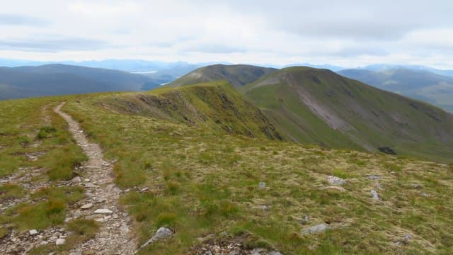
This Geal-charn — one of several so named across the Highlands — is the 1132m Munro east of Loch Pattack, well inside the Ben Alder forest. The summit cairn is on a wide pale stony top, looking south to Ben Alder itself across the high bealach, west into the great Loch Ossian wilderness, and east across the Pattack moors to Dalwhinnie. The hill is one of the four Pattack Munros (Geal-charn, Aonach Beag, Beinn Eibhinn, Carn Dearg) that form a classic remote ridge round from Culra.
Gaelic: “white, cairn-topped hill” · Pronunciation: gyal charn
Quick facts
- Height
- 1131.4m/ 3712ft
- Prominence
- 409 m
- Distance
- 18 km
- Ascent
- 996 m
- Time
- 6–9 hrs
- Grid ref
- NN469746
- Parking
- NN634849
- Nearest city
- Fort William· 36km
- Dogs
- Dogs on lead required near livestockDog-friendly guide ↗
Height and prominence cross-checked against the Database of British and Irish Hills (CC BY).
No GPX track yet
Walked this route? Share your track to help other walkers.
Standard route
Estate track 40% · Open moorland 45% · Summit 15%
The standard line is from Dalwhinnie via Loch Pattack — a 14km bike approach to Culra is the usual start. From the wild-camp area at Culra, climb the Lancet Edge or the long east ridge of Geal-charn. Most parties combine all four Pattack Munros in a long round of 30km+ with 1500m of ascent. The 18km/996m figures relate to Geal-charn alone from a Culra base; bike-and-walk total from the road is significantly more.
Terrain
The Dalwhinnie / Loch Pattack estate road is firm gravel — bike-friendly. The Lancet Edge ridge route is a Grade 1 scramble on rocky steps; the alternative east ridge is broad grass and rock. The summit plateau is wide pale gravel and short heather. No exposure on the standard line via the east ridge.
In winter
A serious winter day in remote country. The Lancet Edge in winter is a recognised Grade I-II winter route. Cornices form along the summit edges. The Pattack moors fill with deep wind-blown snow. Phone signal is absent throughout; Culra is now ruined as a bothy so wild-camping or Ben Alder Cottage are the only shelter options. SAIS Lochaber covers the area.
This hill is in the Creag Meagaidh SAIS forecast area. Check SAIS forecasts in winter (December–April).
Best time of year
Getting there
- Glasgow2h 20m
- Edinburgh3h 43m
OS maps: OS Landranger 42
Mobile signal: No coverage above 700m on the Monadhliath plateau. The Newtonmore area has 4G. The approach tracks into the hills lose signal quickly. Download mapping before departing Newtonmore or Laggan.
Current conditions
Daylight Today
- Sunrise
- 05:00
- Sunset
- 21:49
- Civil dawn
- 04:05
- Civil dusk
- 22:44
NOAA Solar Calculator · 23 July 2026
Pair with
Curated multi-hill combinations from Geal-charn.
Around Geal-charn on the SCOT network
Getting there, basing yourself, and what to do off the hill.
Getting there: Tulloch station
Loch Treig; Beinn na Lap; Stob Coire Easain / Stob a Choire Mheadhoin approach
13km from the hill
tripscot.co.uk
On TripSCOTBase yourself in Fort William
Ben Nevis base, West Highland Line, gateway to Lochaber
36km from the hill
tripscot.co.uk
On TasteSCOTAfter the hill: Dalwhinnie
Dalwhinnie — Scotland's highest distillery on the Drumochter pass
20km from the hill
tastescot.co.uk
Geal-charn — common questions
- Is Geal-charn a hard climb?
- Geal-charn is rated 4/5 (challenging) on the OutdoorSCOT scale. The standard route covers about 18km with 996m of ascent and takes most walkers 6-9 hours. Underfoot: The Dalwhinnie / Loch Pattack estate road is firm gravel — bike-friendly.
- What is Geal-charn's prominence?
- 409m of prominence. That's the vertical drop from the summit to the col that links Geal-charn to the next higher ground.
- Where do I park for Geal-charn?
- Most walkers start from NN634849. Verify the grid reference on an OS map before you set off — space is tight on busy summer weekends.
- When is the best time to climb Geal-charn?
- May, June, July, August, September, October give the most reliable conditions on Geal-charn. Beyond that window the high ground turns wintry: carry full mountain kit, be confident navigating, and check the SAIS avalanche forecast for the area.
- Is Geal-charn dog-friendly?
- Yes, but dogs must be kept on a lead — there is livestock or ground-nesting bird interest on the route.
- Is there mobile signal on Geal-charn?
- No coverage above 700m on the Monadhliath plateau. The Newtonmore area has 4G. The approach tracks into the hills lose signal quickly. Download mapping before departing Newtonmore or Laggan.
- Is Geal-charn safe in winter?
- A serious winter day in remote country. The Lancet Edge in winter is a recognised Grade I-II winter route. Cornices form along the summit edges. The Pattack moors fill with deep wind-blown snow. Phone signal is absent throughout; Culra is now ruined as a bothy so wild-camping or Ben Alder Cottage are the only shelter options. SAIS Lochaber covers the area.
Get the OutdoorSCOT weekly
One email a week — new route, hill and bothy guides, seasonal conditions and the odd hard-won lesson. No spam, unsubscribe in one click.