Munro · Central Highlands
Beinn Eibhinn
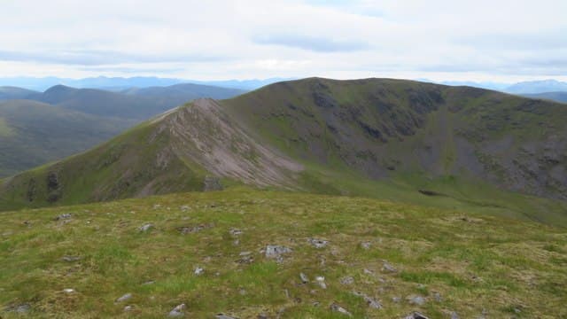
Beinn Eibhinn — "fair-coloured hill" — is the 1103m western Munro of the four-Munro Loch Pattack round, sitting on the long Ben Alder plateau ridge. The summit is a small cairn on a broad ridge of stones, with views down to Loch Ossian and Corrour to the west, and across to the great hulk of Ben Alder south. With Aonach Beag, Geal-charn and Carn Dearg, it forms one of the major remote Munro rounds in the central Highlands.
Quick facts
- Height
- 1103.3m/ 3620ft
- Prominence
- 127 m
- Distance
- 18 km
- Ascent
- 971 m
- Time
- 6–9 hrs
- Grid ref
- NN449733
- Parking
- NN634849
- Nearest city
- Fort William· 34km
- Dogs
- Dogs on lead required near livestockDog-friendly guide ↗
Height and prominence cross-checked against the Database of British and Irish Hills (CC BY).
No GPX track yet
Walked this route? Share your track to help other walkers.
Standard route
Loch Pattack track 45% · Open plateau 35% · Summit 20%
The classic line is the four-Munro Pattack round from Dalwhinnie, with a 14km bike approach to Culra and the route climbing west-to-east over Beinn Eibhinn, Aonach Beag, Geal-charn and Carn Dearg. Around 30km on foot from Culra with 1500m of cumulative ascent. The shorter Corrour Station approach (rail-served) hits Beinn Eibhinn first from the west — useful for a 2-day expedition.
Terrain
The Pattack estate road is firm gravel — best with a bike. The climb onto the plateau from the Allt Cam is on rough heather and grass. The summit ridge is broad short turf with intermittent path; the cairn is small but on a clear high point. No exposure on the standard line.
In winter
A major remote winter day. The plateau picks up sustained snow cover and gets drifted deep against the broad slopes. Cornicing on the north side of Beinn Eibhinn faces Loch Ossian. Phone signal is absent throughout. SAIS Lochaber covers the area indirectly; carry full winter kit and plan around daylight.
This hill is in the Creag Meagaidh SAIS forecast area. Check SAIS forecasts in winter (December–April).
Best time of year
Getting there
- Glasgow2h 19m
- Edinburgh3h 43m
OS maps: OS Landranger 42
Mobile signal: No signal in the Ben Alder area. Dalwhinnie or Newtonmore has 4G. Store maps ahead of the long approach.
Current conditions
Daylight Today
- Sunrise
- 05:01
- Sunset
- 21:49
- Civil dawn
- 04:06
- Civil dusk
- 22:44
NOAA Solar Calculator · 23 July 2026
Pair with
Curated multi-hill combinations from Beinn Eibhinn.
Around Beinn Eibhinn on the SCOT network
Getting there, basing yourself, and what to do off the hill.
Getting there: Corrour station
Highest mainline station; Loch Ossian, Ben Alder, Aonach Beag (Alder)
11km from the hill
tripscot.co.uk
On TripSCOTBase yourself in Fort William
Ben Nevis base, West Highland Line, gateway to Lochaber
34km from the hill
tripscot.co.uk
On TasteSCOTAfter the hill: Dalwhinnie
Dalwhinnie — Scotland's highest distillery on the Drumochter pass
22km from the hill
tastescot.co.uk
Beinn Eibhinn — common questions
- How difficult is Beinn Eibhinn?
- Beinn Eibhinn carries a 3/5 (moderately challenging) grade on the OutdoorSCOT scale. Count on about 18km, 971m of ascent and a 6-9 hour day on the standard route. Ground conditions: The Pattack estate road is firm gravel — best with a bike.
- How much drop does Beinn Eibhinn have?
- The drop is 127m: measured from the summit of Beinn Eibhinn down to the saddle joining it to higher terrain.
- Where's the parking for Beinn Eibhinn?
- Park at NN634849. Double-check the grid reference on an OS map first; informal laybys here fill early in high season.
- What's the best month to climb Beinn Eibhinn?
- Aim for May, June, July, August, September, October on Beinn Eibhinn. In the remaining months treat it as a winter hill — full kit, solid navigation, and a look at the relevant SAIS avalanche forecast before you go.
- Can dogs go up Beinn Eibhinn?
- Dogs are fine on a lead. The route passes livestock or ground-nesting bird habitat, so keep them close throughout.
- Will I get phone signal on Beinn Eibhinn?
- No signal in the Ben Alder area. Dalwhinnie or Newtonmore has 4G. Store maps ahead of the long approach.
- Is Beinn Eibhinn safe in winter?
- A major remote winter day. The plateau picks up sustained snow cover and gets drifted deep against the broad slopes. Cornicing on the north side of Beinn Eibhinn faces Loch Ossian. Phone signal is absent throughout. SAIS Lochaber covers the area indirectly; carry full winter kit and plan around daylight.
Get the OutdoorSCOT weekly
One email a week — new route, hill and bothy guides, seasonal conditions and the odd hard-won lesson. No spam, unsubscribe in one click.