Corbett · Central Highlands
Stob an Aonaich Mhoir
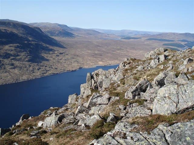
Stob an Aonaich Mhoir is a quiet 855m Corbett on the east side of Loch Ericht, deep in the Ben Alder Forest. It sits across the loch from Ben Alder itself and is rarely visited compared to its Munro neighbours; most parties tackle it as a bike-and-walk expedition rather than a single day on foot. The summit is a small rocky outcrop on a long heathery ridge, with a striking view west across Loch Ericht to the cliffs of Ben Alder's east face.
Quick facts
- Height
- 855.6m/ 2807ft
- Prominence
- 232 m
- Distance
- ~15 km
- Ascent
- ~752 m
- Time
- 5–7 hrs
- Grid ref
- NN537694
- Parking
- NN634849
- Nearest city
- Fort William· 43km
- Dogs
- Dogs on lead required near livestockDog-friendly guide ↗
Height and prominence cross-checked against the Database of British and Irish Hills (CC BY).
No GPX track yet
Walked this route? Share your track to help other walkers.
Standard route
estate road 50% · open heather 25% · broad ridge 20% · summit rocks 5%
The most direct line uses the locked estate road south from Dalwhinnie along the east shore of Loch Ericht for around 12km — a long flat bike ride to the foot of the hill at Ben Alder Cottage area. From there a track climbs east before peeling off onto open heather and grass to the summit. Around 15km/752m of ascent for the hill alone; total bike-and-walk day is 35–40km. Alternative approach from the south via Bridge of Gaur is similar in length.
Terrain
The Loch Ericht estate road is a well-graded gravel surface — ideal for bikes. Off the road the hillside is open heather and grass with no path; the climb to the ridge is gentle but slow over peat hag. The summit ridge is broad with the rocky outcrop at the high point hard to spot in mist among the surrounding bumps. No exposure or technical ground.
In winter
A surprisingly committing winter day because of the distance. The estate road is exposed to easterly winds funnelled down Loch Ericht. Bikes are not feasible under snow. The hillside itself is benign — no avalanche concerns or cornices — but the long return in fading light is a real consideration. Dalwhinnie is reliably accessible by car and train.
Kit for this: the winter Munro kit list · which boots take crampons
Best time of year
Getting there
- Glasgow2h 13m
- Edinburgh3h 32m
OS maps: OS Landranger 42
Mobile signal: Intermittent at Dalwhinnie; no signal down Loch Ericht
Current conditions
Daylight Today
- Sunrise
- 07:47
- Sunset
- 18:20
- Civil dawn
- 07:09
- Civil dusk
- 18:58
NOAA Solar Calculator · 14 October 2026
Around Stob an Aonaich Mhoir on the SCOT network
Getting there, basing yourself, and what to do off the hill.
Getting there: Rannoch station
Rannoch Moor — remote West Highland Line stop; Schiehallion approach via bus
17km from the hill
tripscot.co.uk
On TripSCOTBase yourself in Newtonmore
Creag Meagaidh and Monadhliath access, Wildcat trails
34km from the hill
tripscot.co.uk
On TasteSCOTAfter the hill: Dalwhinnie
Dalwhinnie — Scotland's highest distillery on the Drumochter pass
19km from the hill
tastescot.co.uk
Stob an Aonaich Mhoir — common questions
- What difficulty is Stob an Aonaich Mhoir?
- On the OutdoorSCOT scale, Stob an Aonaich Mhoir comes in at 3/5 — moderately challenging. Expect roughly 15km and 752m of ascent on the usual route — 5-7 hours for most parties. Ground conditions: The Loch Ericht estate road is a well-graded gravel surface — ideal for bikes.
- How much drop does Stob an Aonaich Mhoir have?
- The drop is 232m: measured from the summit of Stob an Aonaich Mhoir down to the saddle joining it to higher terrain.
- Where's the parking for Stob an Aonaich Mhoir?
- Park at NN634849. Double-check the grid reference on an OS map first; informal laybys here fill early in high season.
- What's the best month to climb Stob an Aonaich Mhoir?
- Aim for May, June, July, August, September, October on Stob an Aonaich Mhoir. In the remaining months treat it as a winter hill — full kit, solid navigation, and a look at the relevant SAIS avalanche forecast before you go.
- Can dogs go up Stob an Aonaich Mhoir?
- Dogs are fine on a lead. The route passes livestock or ground-nesting bird habitat, so keep them close throughout.
- Will I get phone signal on Stob an Aonaich Mhoir?
- Intermittent at Dalwhinnie; no signal down Loch Ericht
- Is Stob an Aonaich Mhoir safe in winter?
- A surprisingly committing winter day because of the distance. The estate road is exposed to easterly winds funnelled down Loch Ericht. Bikes are not feasible under snow. The hillside itself is benign — no avalanche concerns or cornices — but the long return in fading light is a real consideration. Dalwhinnie is reliably accessible by car and train.
Get the OutdoorSCOT weekly
One email a week — new route, hill and bothy guides, seasonal conditions and the odd hard-won lesson. No spam, unsubscribe in one click.